Greg O’s Garage; A Flying ‘Feild’ at William K. Vanderbilt Sr’s Idle Hour

Old plans were recently uncovered for a flying 'feild' (incorrect spelling on the plans) on William K. Vanderbilt's Idle Hour Estate property.
Greg O.
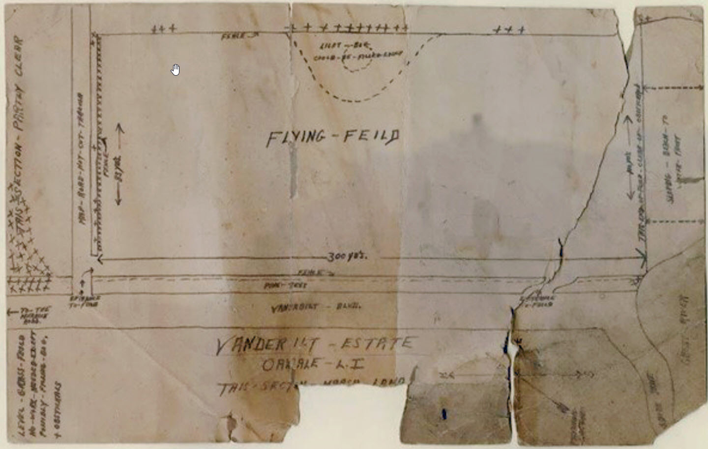
A newly discovered map has become quite the mystery to Vanderbilt family and Idle Hour historians.
Undated, everyone who has looked at the map is unclear as to where on the property the field was supposed to be, and exhaustive research shows no flying field has ever been documented being built on the property or anywhere in the area. Some have presumed that this could have been an addition to the estate when being sold after William K. Vanderbilt's death in 1920.
Orientation of the map has East at the top of the page and North to the left.

The 1915 Belcher-Hyde map shows no indication of a flying field anywhere on the property at that particular time.
No mention of a flying field on the very thorough, and informative 'Abandoned & Little-Known Airfields' site either.
So where was the planned site of this field?

A closer look at some of the map details provide clues as to where it could have been. On the map's right edge states '...berm to the water front' which would have been on the southern edge of the field.

Horizontally across the bottom of the field is Vanderbilt Blvd, which still exists today running North to South possibly indicating this was a later addition after the former estate's crushed stone drive became an officially recognized street.

Turning the map sideways to orientate North up to match a Google Earth view, it becomes a little clearer as to my best guess for the possible location on the former Vanderbilt property.
The green rectangle is where I place the flying field on the Google view on the east side of Vanderbilt Blvd. The plans indicate a road to be cleared along the north edge of the field. Cross Rd exists there now at just about the exact 300-yard distance of the field as indicated on the plans, (seen between the red arrows). The blue arrow points to the nearly identical shape of the Great River shoreline at the location.
This location also makes sense for a flying field as it is the farthest location on the property from the main house.

Finally, the noted marsh lands from the Historic Aerials site do match up with marsh notations on the plans.

A view of the intersection looking South-Southeast at Cross Rd and Vanderbilt Blvd taken today, Feb. 13th, 2023 overlooking what would have been the flying field location. No fence or line of Pines today, but observing the flatness of the area, devoid of marshland that exists all around, this appears that it would have been a perfect location for a flying field, with access to the water if seaplanes were considered.
However, there is one caveat to this entire location theory. At the southeastern section of the Vanderbilt property, the property line followed the eastern edge of Vanderbilt Blvd. Looking at the closeup of the plan's title above, it is noted that there is a fence and a line of Pine trees along that eastern edge of Vanderbilt Blvd with two entrances to the field. This location theory then places the flyng field outside of the boundaries of Vanderbilt's property. It could be speculated that these plans required the purchase of the extra land for the field and the lack of acquisition of this land prevented the field from being built. Correct or not, the rest of the location's clues are too compelling to not believe that this was indeed the possible location. The mystery continues....
Does anyone have any further knowledge of such a flying field on the Vanderbilt property? Let us know in the comments.


Comments
Nice find Greg, thanks again for sharing Vanderbilt history. The airfield on the plan is 900ft x 250ft, constrained within Vanderbilt Blvd and W Shore Rd. I recently landed from SFO-JFK that made it clearer how airports have advanced through the years. The JFK runway was 5000ft
It’s amazing how many airfields there were on Long Island. There was one south of Target in Sayville when I was young. The Aerodrome in Bayport has some history behind it.
Here’s a 1947 Aerial of Idle Hour. If you visit the website, zoom in to view the estate with very good detail. https://gisapps.suffolkcountyny.gov/gisviewer/