Kleiner’s Kolumn: Documenting the Motor Parkway in Relation to the Seaford-Oyster Bay Expressway
Columnist Art Kleiner has researched the Motor Parkway in Bethpage with FOIL request to the New York State Department of Transportation. The results below will be highlighted at a special meeting of the Long Island Motor Parkway Preservation Society and the Central Park Historical Society on Wednesday, October 23, 2019.
Enjoy,
Howard Kroplick
Kleiner's Kolumn: Documenting the Motor Parkway in Bethpage
By Art Kleiner
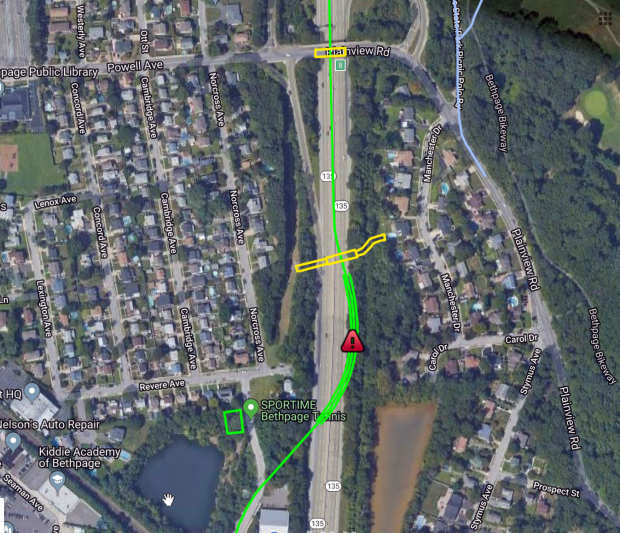
To provide further answers relating to Sam and Dave's Bethpage exploration of the Motor Parkway (August 13th blog) and which generated a lively discussion and field trip, I submitted a FOIL request to the New York State Department of Transportation requesting documents related to the construction of the Seaford-Oyster Bay Expressway in Bethpage.
As a result, The DOT provided me with over 400 pages of surveys, maps, etc. detailing where the expressway was to be built, abutment construction details, land owners, areas and buildings needing to be demolished, etc. I've reviewed each document and present here those that might answer the question of where the Expressway was built in relation to the Motor Parkway.
The Expressway, originally known as the Wantagh-Oyster Bay Expressway, was proposed by Robert Moses in 1954. However, the right of way was not obtained until 1958 with construction beginning in 1959. The road became NY 135 in 1964.
Feel free to comment on what's shown and please add any other observations from what you see. I'll be reviewing more of the over 400 pages provided and will document in future Kleiner's Korners as appropriate.
FOIL Request Received
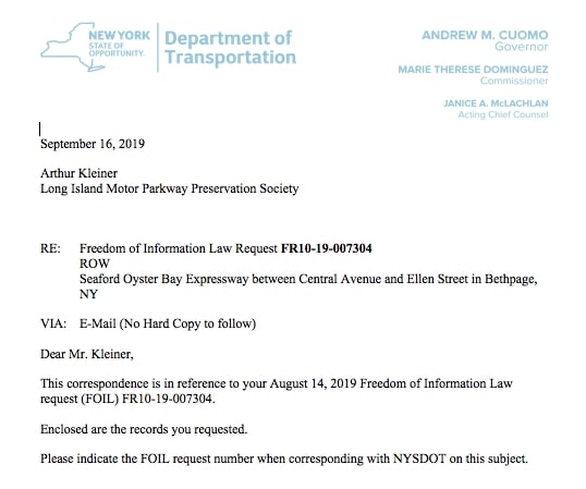
The request was filed on August 14 and true to the ensuing correspondence, it was filled 20 business days thereafter.
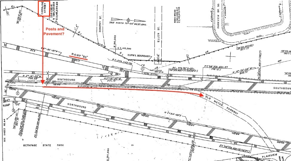
1960: Area showing Caroline Avenue in relation to the Wantagh-Oyster Bay Expressway southbound and northbound lanes and exit ramps. The eastern part of the southbound lane appears to be the Motor Parkway. I've indicated where LIMP posts and thought to be pavement were found. The question mark denotes whether these were originally located here or moved during construction.
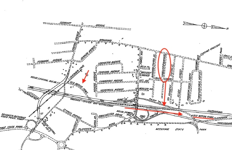
1960: Area showing "Old" Motor Parkway crossing over the LIRR at Central Avenue, continuing northward. Following the Parkway, it again appears to be overlaid on the southbound lane of the Wantagh-Oyster Bay Expressway in the vicinity of Caroline Avenue.
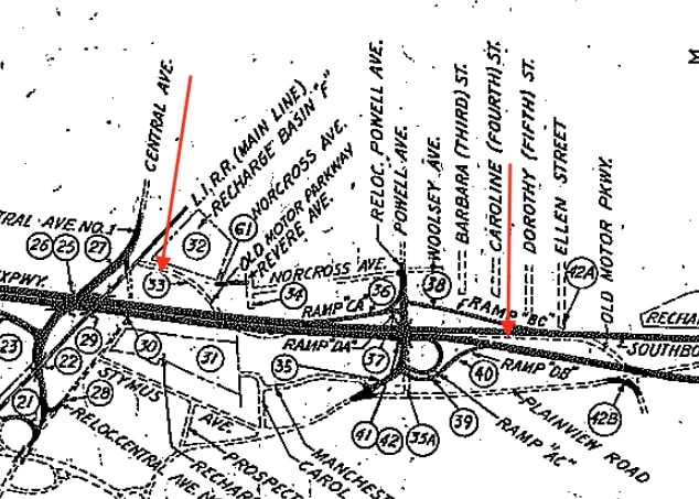
1960: Map showing "Old" Motor Parwkay again crossing over the LIRR at Central Avenue and continuing northward. This and the following chart details how the construction impacted the area, Location 33 "Old Motor Parkway" is indicated as a "portion within WOB Boundaries" destroyed by construction ("abandon and remove").

1960: Topographical survey showing the same area.
Other DOT documents showing the "Old Motor Parkway"
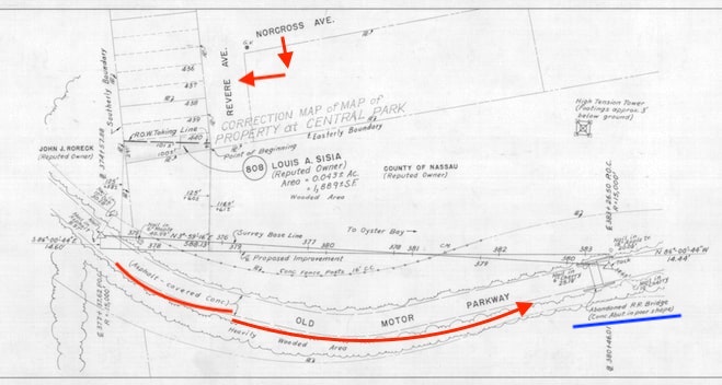
1956: Prior to construction, these surveys were probably used to plan the expressway's route and identify parcels impacted. Note the location of the "Abandoned RR Bridge) and the high tension tower. Note on the Parkway ROW "Asphalt - covered conc.".
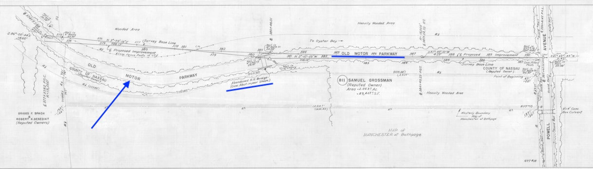
1956
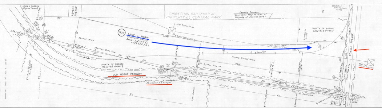
1959: Note the property of Anne L. Merin running parallel to the Expressway and the "Old" Motor Parkway northbound to Powell Avenue. To make this current, we need to insert the location of the abandoned auto on the Merin Property - lol!
1959
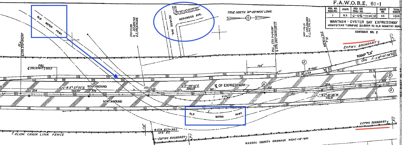
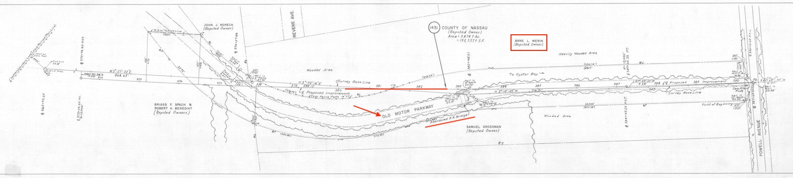
1960: Another neat survey I like showing the boundaries of the expressway, the "Old" Motor Parkway and Revere and Norcross Avenues, the start of our field trip in August.


Comments
I’ll deem these “works of art” : ) Enjoy how detailed the surveys are. They figured the Nibbe Bridge was railroad, boundary fence posts are noted, etc. These surveys and the Google map are alike. 400 pages for just this area, whew!
Brian, the SOB area they provided me went a bit north and then down south to the cloverleaf at Hempstead Turnpike. Also many of the docs were very detailed construction plans regarding abutments, drainage, materials needed (even down to seeding and fertilizing). Not being an engineer, they didn’t mean much to me!
Art - Thank you for your dedication and accomplishment receiving these FOIL documents. 400+ for this small area alone is amazing! I look forward to seeing them at our next meeting. The first survey has headings written all over it ensuring precise location(s), including a “triangular” monument installed in the southbound left lane somewhere, indicating the precise location where the LIMP eastbound curve once started. The only problem locating this small engraved object on the roadway is the 60+ mph traffic whizzing by. We’ll have to temporarily close the left lane to observe. Maybe someday, but for now I’ll stick with the old aerials. Great stuff guys and always something to learn here.
Art—-amazing research. Did they charge you money for this? How does this work? You made the request for information, what is the process after that?
Were there any photos sent? Curious.
Thanks for the kind words all . . . yes, lots of details such as “nail in NYT #16”, “nail in 12’ Apple Tree”, “Chain Link Fence (alum)”, etc. You know I’ll always try to seek out bits and pieces of history, but to that degree, don’t think so - also not willing to shut down the SOB on my own. Maybe I’m getting soft in my old age!
Dave - process is quite easy: or maybe I just had beginners luck. I’ve requested two more FOILs and will see how these go.
There was something that asked if I wanted to be notified if the documentation required a certain cost. For the SOB FOIL I put down $25, but never was told about any resulting charge. Maybe it will end up in my NYS taxes for the year - lol.
Go to go to the local site and follow directions: Nassau -
https://apex4.nassaucountyny.gov/apex/apexprod/f?p=FOIL:FOIL_REQUEST
New York State:
https://www.ny.gov/openfoil/openfoil-resources
Good luck. When describing the request best to be as specific as possible.
And no photos sent, Dave.
Art, Great job, your efforts of wading thru some 400 pages of material most certainly added to our knowledge of the Motor Parkway’s relationship with the SOB especially when it comes to the overlapping of the two roads Thank you.
Thank you for all the great research on our local history. Looking forward to our joint program on October 23. Ann - Central Park Historical Society
For full disclosure, the 400+ pages I reviewed were digitized, not hard copy, making the task much easier by just clicking the next page or down arrow keys.
And the more I review these plans, the more I appreciate the work of civil engineers and surveyers! Without them, our research efforts would be much more limited.
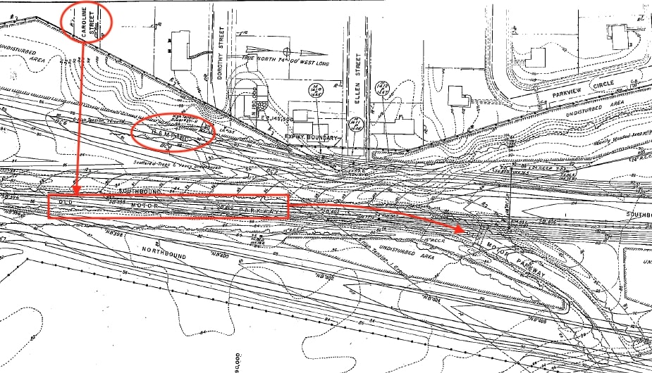
Caroline St posts location in blue on the 1960 topo map, within the hilly area (top photo below).
Also, it appears the Nibbe bridge had outlived the original Powell bridge by some years. In the 1956 survey (bottom photo below), Nibbe is indicated abandoned while Powell had already received an upgrade. Nibbe must have stood until the late ‘50s unlike previously thought to have survived into the ‘40s.