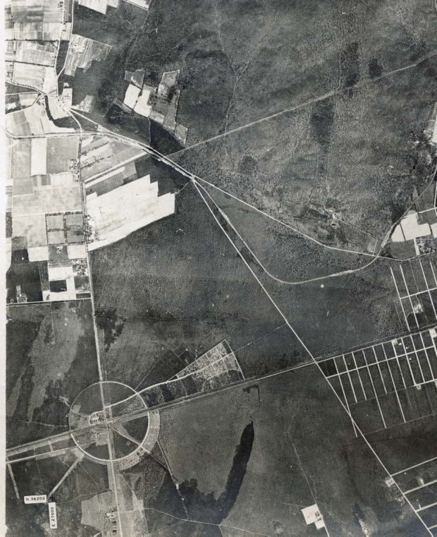
Mystery Foto #5 Solved: A Long Island Motor Parkway Aerial Near Pinelawn Cemetery Circa 1928-1930
Super Bowl LI weekend's Mystery Foto featured a section of the LI Motor Parkway.
Mystery Foto questions:
- Identify the location of this aerial
Melville, Wyandanch and Wheatley Heights
- Identify the Motor Parkway bridges (see belwo Femenias' Findings)
1. Ruland Road Parkway Bridge in Melville
2. Wellwood Avenue Parkway Bridge in Melville
3. Little East Neck Road Parkway Bridge in Wyandanch
4. Half Hollows Road Parkway Bridge (Colonial Springs) in Wheatley Heights
- What is the year of the aerial. Provide a rationale.
Official Suffolk County aerial (circa 1928-1930)
- What other significant landmarks are in the aerial?
Pinelawn Cemetery which in 1936 would become the Long Island National Cemetery and Pinelawn Station
Comments (11)
Congrats to Joe Osterle, Greg O., Bill Schneider, Tim Ivers, Edith Klarmann, Art Kleiner (see Kleiner's Korner). Steve Lucas, Dick Gorman and Frank Femenias (see Femenias' Findings).
Kudos to Edith Klarmann who remembers riding her bicycle on these Motor Parkway bridges!
Enjoy,
Howard Kroplick
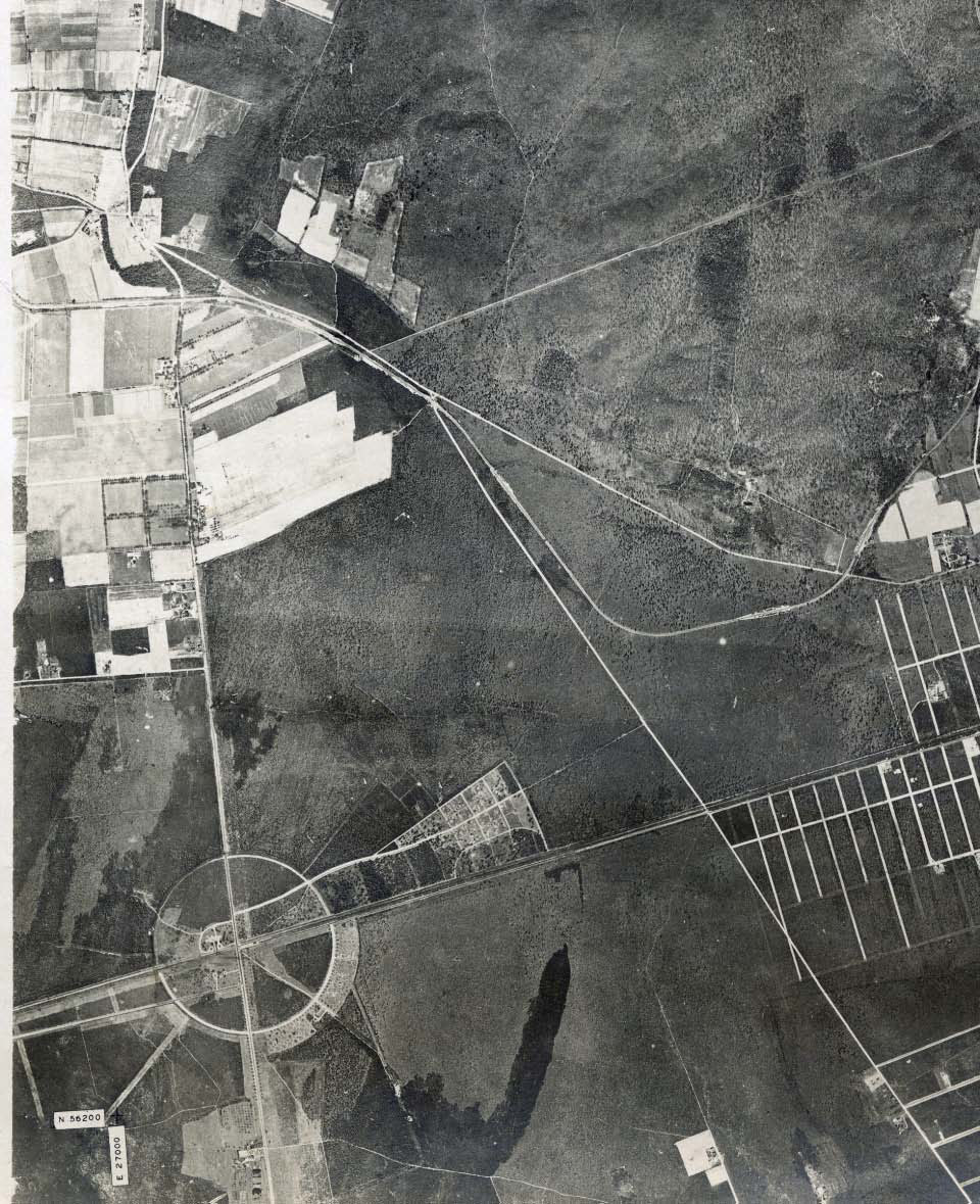
Close-up
Femenias' Findings (Submitted by Frank Femenias)
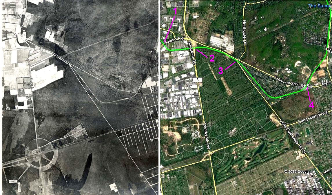
1. Ruland Road Parkway Bridge in Melville
2. Wellwood Avenue Parkway Bridge in Melville
3. Little East Neck Road Parkway Bridge in Wyandanch
4. Half Hollows Road Parkway Bridge (Colonial Springs) in Wheatley Heights
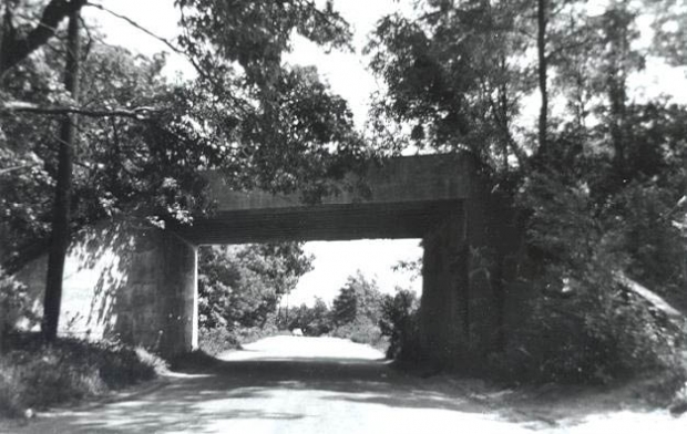
Half-Hollows Road Parkway Bridge
Kleiner's Korner (Submitted by Art Kleiner)
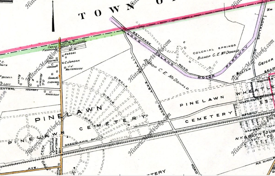
Belcher-Hyde 1915
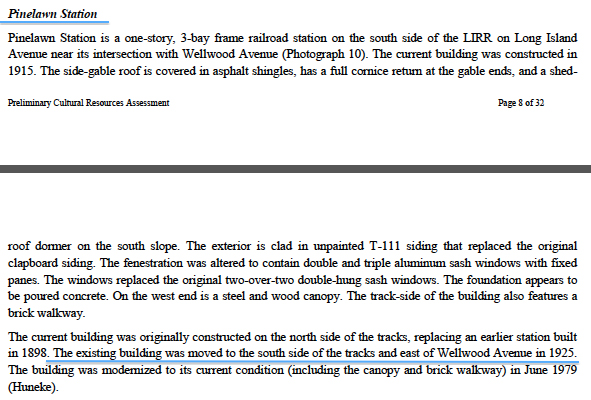
Pinelawn Station


Comments
Pinelawn Cemetery, Colonial Springs Road Area.
Identify the location of this aerial
-Long Island Motor Parkway in Melville and Wyandanch.
Identify the Motor Parkway bridges
-not seen, but on the very left edge would be the Rutland Rd bridge, then the Wellwood Ave bridge, and finally, the Little East Neck Rd. Bridge.
What is the year of the aerial. Provide a rationale.
-1928. I have this aerial in my archives, but also found it used for the Little East Neck Rd post on this site.
What other significant landmark is in the aerial?
-Pinelawn Cemetery and the Long Island National Cemetery.
That’s Pinelawn Cemetery at the bottom (starting at the upper right of the circle) and the land just above it became LI National Cemetery in 1936. So This has to be pre-1936.
The upper left is here Wellwood Ave and Little Neck Road meet just south of Melleville.
Not sure about the bridges.
1928 aerial over Wyandanch
Circular road area became Pinelawn in 1935.
Little East Nexk road bridge visible
Starting in the Upper Left-Hand Corner, coming from the LIMP bridge Rd over Ruland Rd (just out of sight in this foto) is the LIMP crossing over Pinelawn Rd slightly below the confluence of Ruland Rd, Pinelawn Rd, Duryea Rd, Old Baylis Rd & Colonial Springs Rd, with the LIMP continuing some distance along but at a slightly higher elevation with Colonial Springs Rd. Pinelawn Rd then continuing thru the circle, the center of which crosses with the LIRR, parallel to which is the then continuation of Conklin Street, this location being that of Pinelawn Cemetery, also a stop on the LIRR. As to approximate year, that would be the early thirties inasmuch as Republic Aviation is yet appear in the foto.
If I am correct, then that is because in the early fifties we would bicycle on the then closed LIMP—from the LIMP bridge crossing Route 110 to bit along the LIMP where it parallels Colonial Springs Rd to visit a friend of my parents then living on Colonial Springs Rd as there was a path leading from the LIMP down to their house on Colonial Springs Rd. But, if I am wrong then it is age and memory that have merely played a trick on this older senior in taking her back to an earlier time long since gone.
Identify the location of this aerial: Wyandanch, Wheatley Heights, Colonial Springs Road
From my website
http://www.freewebs.com/limparkway/colonialspringsrdupdate.htm
Identify the Motor Parkway bridges: Colonial Springs Road, Little East Neck, Pinelawn Road, Ruland Road
What is the year of the aerial. Provide a rationale.: 1928 Before Pinelawn National Cemetary purchased the property (also date mentioned in an earlier blog)
What other significant landmark is in the aerial? Pinelawn Cemetery, Pinelawn LIRR station
From Richard Krause:
From the general overall appearance of the roadways, I suspect the “Rounded area,” of this photo, could be of the original portion of Hempstead Turnpike and the south section of Broadway. in what is now Bethpage? Originally “Central park” . The completely wooded portion of property ( on the upper right hand side of this photo, might be? Of what we now know to be the Bethpage state golf course. this is a wonderful photo, and in studying the picture. I find it so much fun, to guess at, where it might be! You newsletter is an adventure all in itself! And I suspect I am far from alone in enjoying the wonders of “Vanderbiltcup.com” News letter! Please keep up what you do, for not only is this educational, but is so much fun!
The photo was taken from a point almost directly over what would become Pinelawn National Cemetery with north being at the top of the picture. The three LIMP bridges that are definitely there are: Half Hollows Road (Colonial Springs Rd.); Little East Neck Road; and Wellwood Avenue (Pinelawn Rd.) with Ruland Road and Smith Farmway (Maxess Rd.) just out of sight to the upper left. Since the cemetery was established in 1936 with the first burials starting in March, 1937, I’m going with a date of 1937 because it looks like some activity has taken place and the circular area around the LIRR station has been set up.
No mystery whatsoever! The curves on the LIMP at upper right give it away. We’re directly above today’s Salisbury Park Drive and Friends Lane, with Carman Avenue heading straight down at left and Old Westbury Road down to the right. The LIRR Central Branch runs diagonally left to right but I have no recollection of the big circle at the LIRR so I could easily be all wet here. Let the other experts fill in the rest (especially if I’m dead wrong!). Sam, III :·)
Mystery Foto #5….This aerial location is Wyandanch and Wheatley Heights. The bridges shown in the aerial are Little East Neck Road Motor Parkway Bridge and Half Hollows Road Motor Parkway Bridge. The photo was taken in 1928. And the other landmark is the circular roadway in the Pinelawn Memorial Park.
Wheatley Heights/Wyandanch – North up
Bridges:
1. Ruland Rd parkway bridge
2. Wellwood Av parkway bridge
3. Little East Neck Rd parkway bridge
4. Colonial Springs parkway bridge (Half Hollows Rd)
1928 – Pre Long Island National Cemetery (1936), Pre Colonial Springs Golf Club (1995)
Pinelawn Memorial Park
Well, duh! So obvious as to be painful once shown but rather funny how the curves line up. First impressions rule (wrongly)! Sam, III