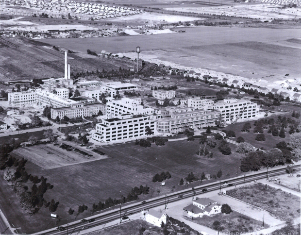
Mystery Foto #76 Solved: An Aerial of Meadowbrook Hospital and East Meadow Circa 1951/1952
This week's Mystery Foto was a vintage aerial of Long Island landmarks.
Mystery Foto questions:
-What is the location and orientation of the aerial?
East Meadow, looking north/northeast from Hempstead Turnpike. As noted by Tim, East Meadow was my boyhood hometown.
-Identify the landmarks
Meadowbrook Hospital, now Nassau University Medical Center
The Westbury Road (Old Westbury Road) Bridge- one of the original Motor Parkway bridges built in 1908 can be seen in the top center of the aerial.
The Motor Parkway Bridge (later and currently Salisbury Park Drive Bridge) over Wantagh State Parkway built in 1938 by New York State.
-Identify the roads in the aerial
Hempstead Turnpike across the bottom.
Carman Avenue in the left corner.
Clearmeadow Drive, east of the hospital.
Salisbury Park Drive (formerly the Long Island Motor Parkway) across the top.
- Give your rationale for the approximate date of the aerial.The photo was not dated.
The aerial was undated. However, the comments provided by Greg O. and Art Kleiner dated the aerial around 1951 to 1952.
Congrats to Michael LaBarbera, Tim Ivers, Mitch Kaften, Greg O., Bob and Ann Albertson, Steve Lucas, Dave Lieberman, Art Kleiner, and Marion for identifying Meadowbrook Hospital in East Meadow. Special kudos to Tim Ivers, Greg O., Steve Lucas, and Art Kleiner for recognizing the two Motor Parkway bridges. Super huzzahs to Greg O. and Art Kleiner for their dating skills.
Enjoy,
Howard Kroplick
Close-Ups
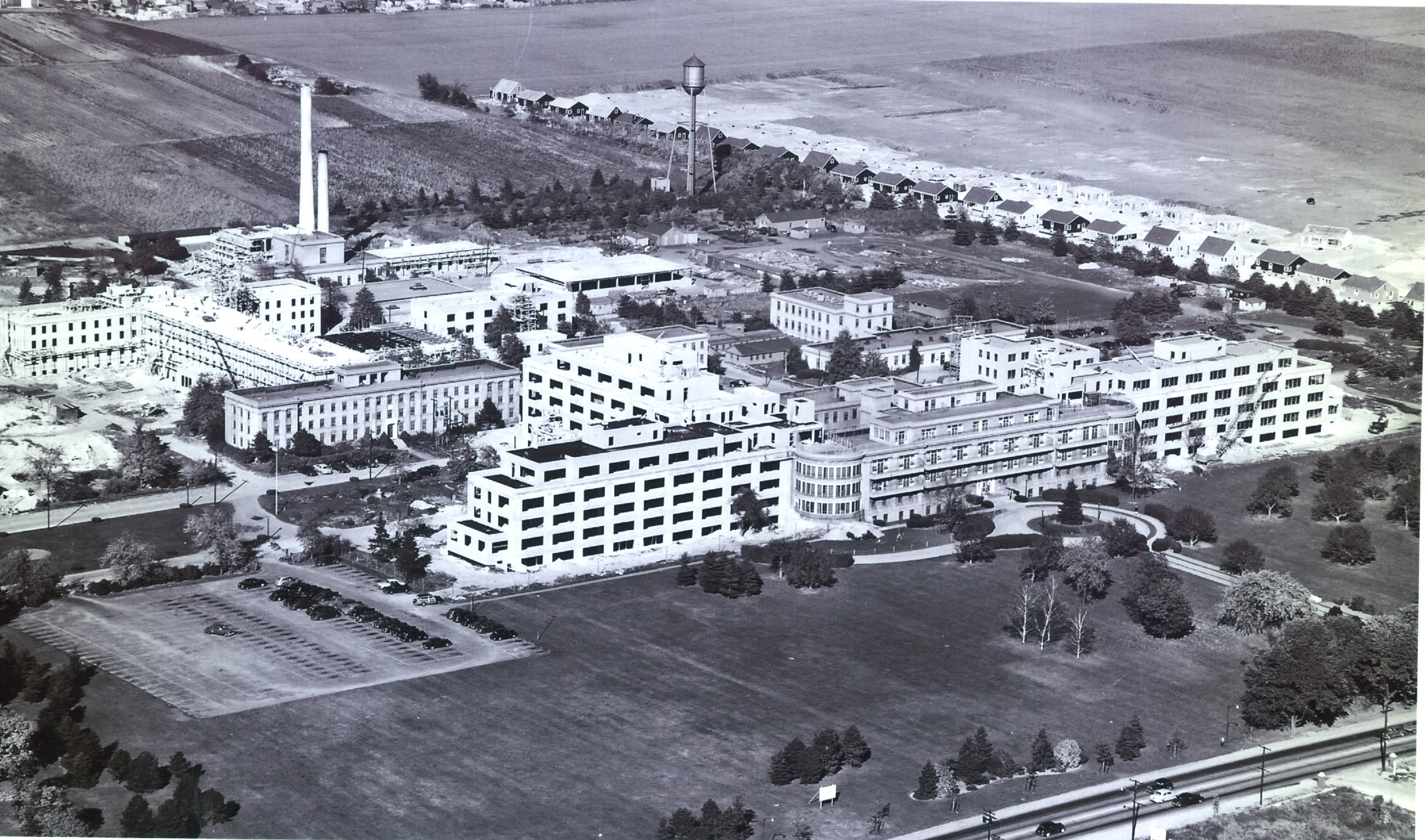
Meadowbrook Hospital as I remember it as a toddler.
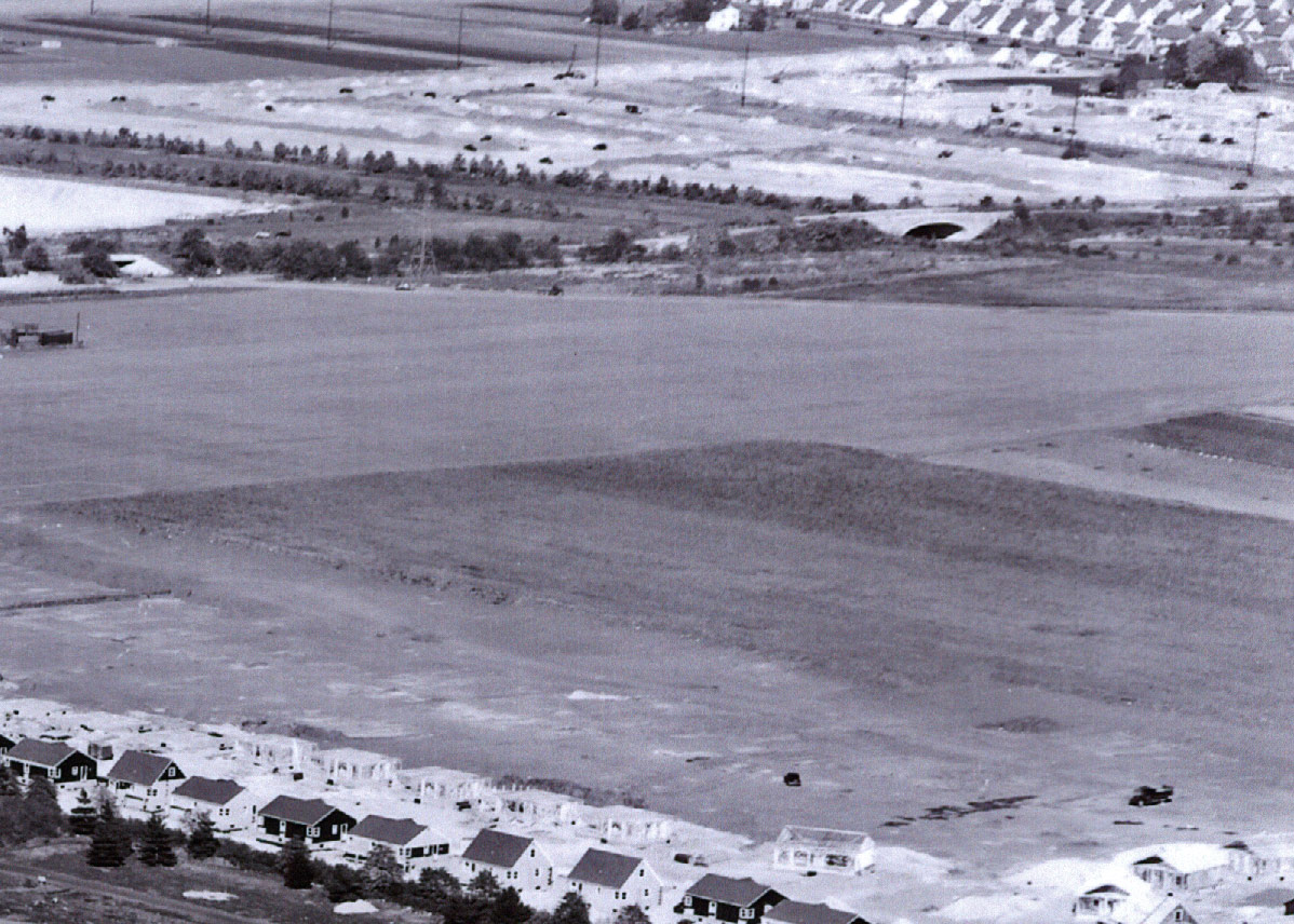
Westbury Road Motor Parkway Bridge on the left and the Motor Parkway (Salisbury Park Plains Road) Bridge over Wantagh State Parkway on the right.

A current Bing Map view of the area.
Articles Forwarded by Art Kleiner
Newsday, July 22,1950
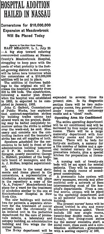
New York Times, July 23, 1950
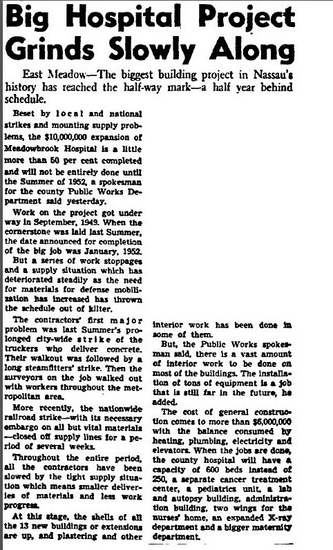
Newsday, March 12, 1951


Comments
Nassau County Medical Center (NUMC) East Meadow. With the Jail just to the north of the hospital. My guess is 1948 or very soon after WWII. Facing North from Hempstead Tpk. The close up looks like Salisbury Park Drive crossing over the Wantagh Pkwy (which is the reason for today’s photo?) . The central RR should be just north of the Jail, but i cant seem to find it in the picture. I think the hospital building is still there, but hidden behind the big 18 story tower now. Parking lot is still the same.
It looks to be Howard’s old neighborhood, East Meadow…..looking northeast with Hempstead Tpke running l to r across bottom, Carman Ave. lower left running north; old Meadowbrook Hospital in dead center with the county jail behind to left and the sprawling jail farm behind.
At the top in the distance can be seen Salisbury Park Drive with the LIMP running across the back of the farm and the Limp bridge over Old Westbury Rd. And another LIMP bridge over Wantagh State Pkwy. I estimate the photo date to be 1947 because the first section of the new Levittown appears at the far top right.
Meadowbrook Hospital, with the LIMP in the background?
-What is the location and orientation of the aerial?
Meadowbrook Hospital in East Meadow (Now NUMC) looking North/NorthEast.
-Identify the landmarks
Meadowbrook Hosp., R. Moses bridge over the Wantagh Pkwy in the upper right, The LIMP Westbury Ave PW bridge to the left of the RM bridge.
Zooming in very tight on the hospital parking lot shows a neat, classic ‘Woody’ station wagon parked closest to the hospital. Wouldn’t mind having that car today!
-Identify the roads in the aerial
Hempstead Tpke along the bottom with a small sliver of Carman Ave showing. The Wantagh Pkwy upper right.
- Give your rationale for the approximate date of the aerial.The photo was not dated.
1951-
I checked the construction dates on the Zillow and Redfin real estate sites for the homes being constructed on Clearmeadow Dr east of the Hospital in the photo. Most homes we constucted in 1951-52.
Ya got me, had trouble with this. Looks like a LI Motor Parkway bridge at the top center and a NY State Parkway bridge to the right of it in this Fairchild aerial. Closest I was able was Levittown facing SW with LIMP Newbridge Rd Pkwy bridge and the Wantagh State Pkwy bridge, just after starting the May 1947 construction of the Levitt homes. Old Country Rd diagonal at the bottom. Clueless on those buildings in the foreground. Looking forward to the obvious answer.
I was going to say the Doubleday publishing plant, but the background looks more like Levittown.
Meadowbrook Hospital and Nassau County Jail in background. Hempstead Tpk. in the front. Approximately late 1940’s to early 1950 by noting the cars in the picture.
This photo appears to be looking north-north-east in East Meadow with the Meadowbrook Hospital in the center. I think the original Nassau County Correctional Facility is the H-shaped building on the left side. The roads are Carman Avenue and Hempstead Tpke. near the bottom with the LIMP running left to right near the top. I believe there are two LIMP bridges visable: over Old Westbury Road and Wantagh Parkway. It looks like the early stages of Levittown in the upper right corner so I’ll say it dates from 1947.
It looks like Meadowbrook Hospital from Hempstead Turnpike looking northeast. From the light colored car, which looks like a Plymouth or Dodge, it appears to be from the early 50’s
This one is practically in my backyard!
-What is the location and orientation of the aerial?
Meadowbrook Hospital (now NUMC) in East Meadow. Looking northeast.
-Identify the landmarks
Meadowbrook Hospital. Westbury Road Motor Parkway Bridge crossing the Motor Parkway in the top left of the close-up (to the left of the electrical tower). Wantagh Parkway bridge to the right of the Westbury Bridge. Levitt homes all the way on the top right portion of the pic, best seen in the close-up.
-Identify the roads in the aerial
Hempstead Turnpike at the bottom running left to right. Carmen Avenue in the left corner. Clearmeadow Drive on the right side of the hospital where the homes are being built. Motor Parkway running left to right at the top, near the bridges. Westbury Road running diagonally off of the Motor Parkway on the right side by the bridge. Wantagh Parkway being extended, with the trees on the top right.
- Give your rationale for the approximate date of the aerial.The photo was not dated. I would say 1951- a) homes on Clearmeadow Drive were built in 1951 based on the Nassau County Tax Assessor’s records; b) major additions to the hospital were occurring in 1951 (Howard, I’m sending along two pertinent articles, especially the one about construction being held up due a construction strike possibility). c) Motor Parkway Westbury Road bridge was not taken down until 1955; d) Wantagh
Parkway extension occurring in 1951.
I think it may be Meadowbrook Hospital on Hempstead tpke around 1944.
The homes in the background are just being built, Levittown?
Was away for the weekend and didn’t get a chance to work on this and I don’t think I have ever seen this area before. To me it looks as though this area was built up. The buildings look pretty modern to me, so the aerial most have been taken between 1998 and 2000. I had to give you my thoughts about it, I couldn’t just let it go, even if I don’t have any answers
I’m reading these answers and not believing what I’m reading, Can’t believe that it’s the Meadowbrook Hospital. I got totally thrown off by all the buildings and I said I have never seen this area before, that was the shocker, how’d I miss it, I’m always around their
So this is what the original hospital looked like. This is very cool. I’ve heard about local East Meadow residents resisting the construction of the new 18 story structure. And if Michael says, that the original hospital structures still exists there today, hiding behind the 18 story tower, I’ll be visiting there soon to check this out!
Did we ever explore the segment between Carman and the Wantagh? The RoW is so clear on the Google and Bing satellite views but I don’t recall it at all. If you covered it on your blog, where please? If not, somebody please get in there with a camera. Sam, III
Second thought - if you look at the bottom (S end) of the loop ramp from Stewart Ave. E/B onto Meadowbrook Pwy. N/B, a RoW still shows! Is that LIMP or Central RR of LI? If CRR, I cover the old bridge in there on a yet-unrestored CRR page. If LIMP, same question - have you been in there and is it covered somewhere? Sam, III
I have been looking for a photo of the old Meadowbrook Hospital to show my husband (he’s younger than me and only knows of it the way it is now). I have such fond memories of sitting under those trees with my grandmother and sister when I was a little girl. I think my mother and grandmother were taking turns visiting my great grandmother. I believe they were crab apple trees. It was so beautiful and peaceful there. We would read stories and have snacks, and watch the cars go by. I’m so happy to see this photo!
I remember the hospital well as I delivered a Newsday paper to the Morgue located down a driveway to the first basement level. This was probably 1954-55.
________________________________________________________
From Howard Kropkick:
Brad, I delivered Newsday in East Meadow, too!
My Grandfather, Father and myself worked at “Meadowbrook Hospital” since it opened back in the late 1930’s I believe. In this photo taken early 1950’s there is No Nassau County Correction Center in the background. I don’t believe the jail was build until the early 1960’s. It was the best “state-of-the-art” hospital at the time.
————————————————————————————————————
From Howard Kroplick
Bill, I was raised in East Meadow and remember Meadowbrook Hospital very well!!