Mystery Foto #10 Solved: A 1953 East Williston aerial from the Cradle of Aviation Archives
The Cradle of Aviation challenges you to solve this weekend's Mystery Foto.
Answers to the Mystery Foto questions:
Identify:
- The location and orientation of the photographer
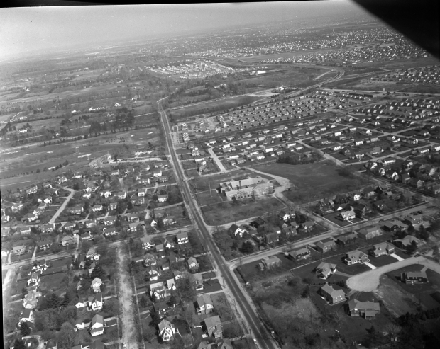
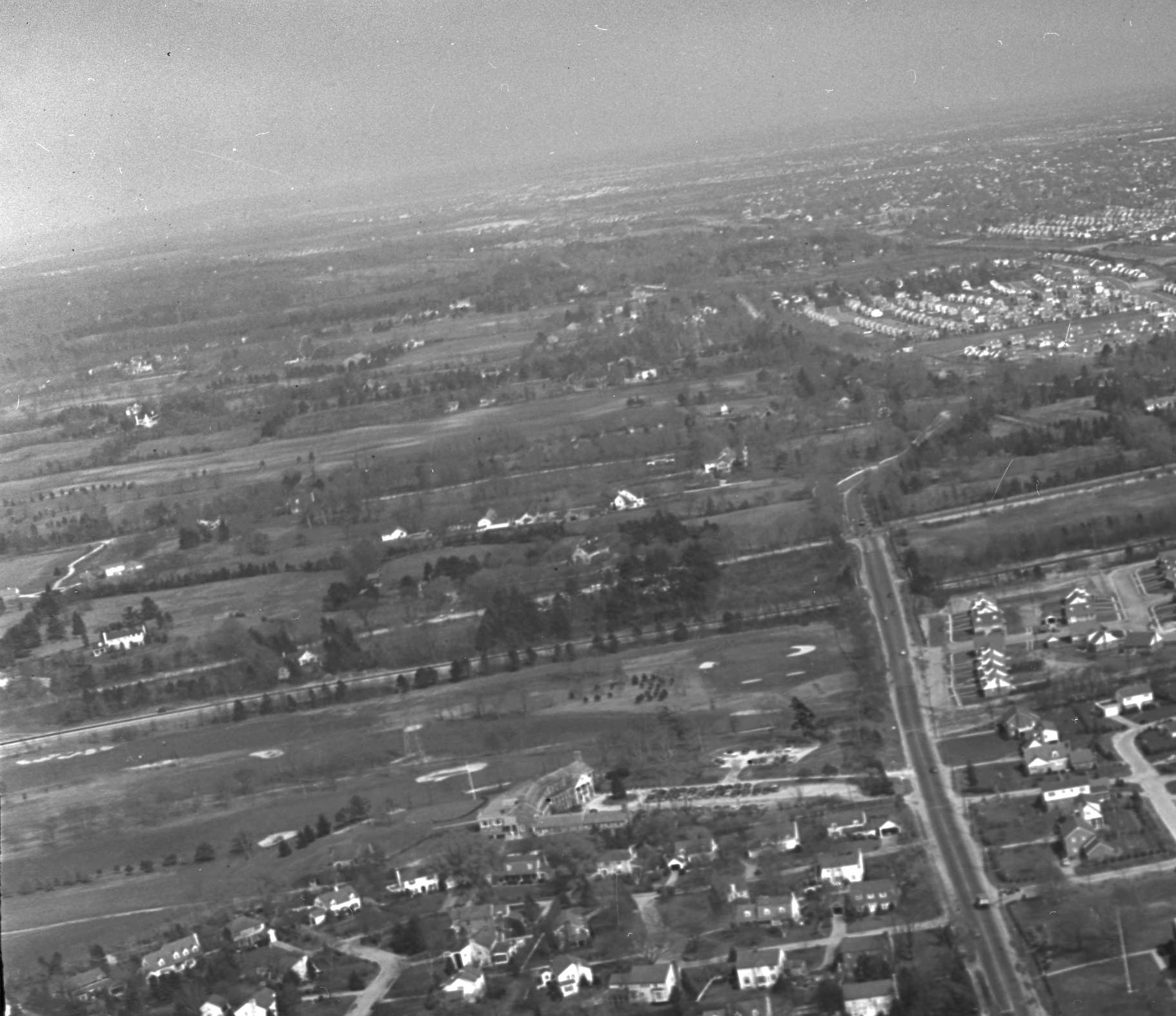
View looking east over East Williston with Old Westbury and Westbury in the background.
- The major roads
Hillside Avenue (East Williston Avenue) is the major road in the middle. The "objectors' bend" of the Northern State Parkway and Guinea Woods Road (Glen Cove Road) can be seen on the top.
- The golf course
Wheatley Hills Golf Club
- The large building in the middle of the photo
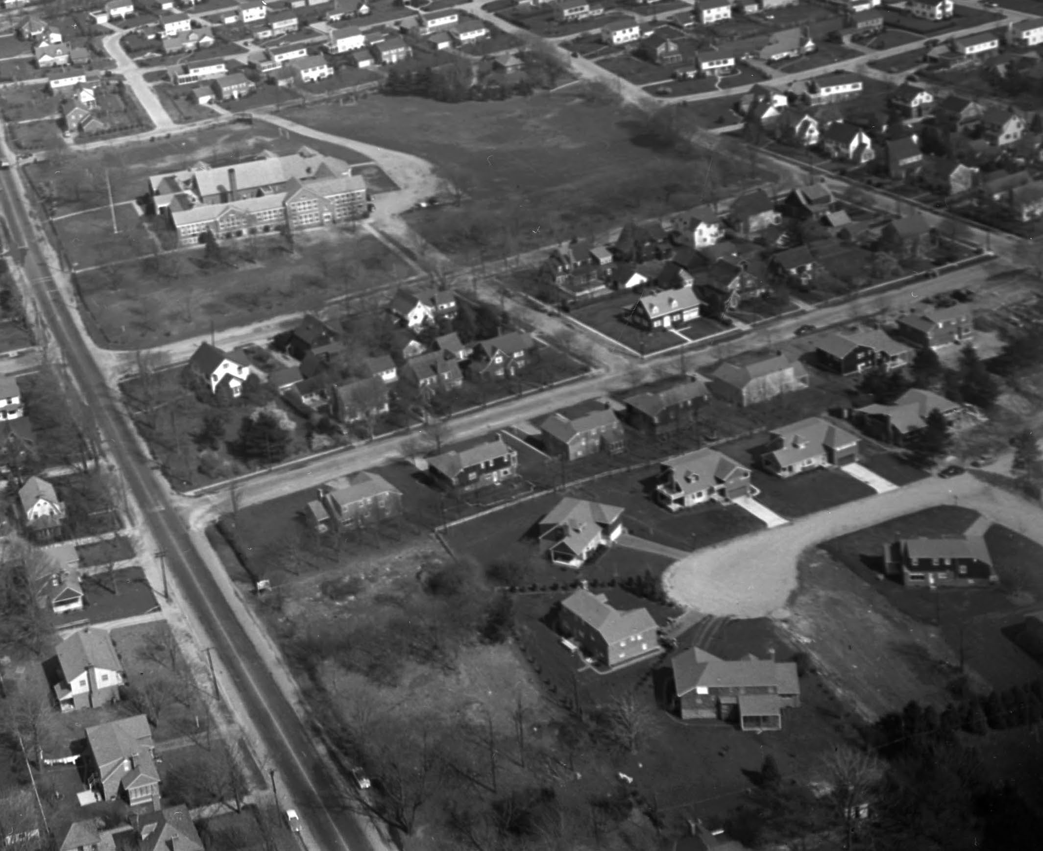
North Side School on the "southside" of Hillside Avenue.
- The Long Island Motor Parkway right-of-way and a Motor Parkway structure
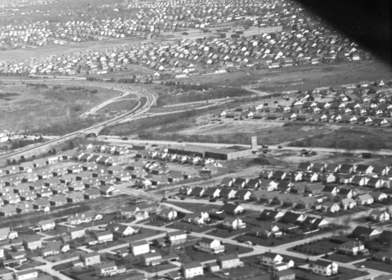
See the below jpegs in the Comments section. The Jericho Turnpike Motor Parkway Bridge is the only extant structure in the Foto.
- Link the Mystery Foto to the Vanderbilt Cup Races
This section of the Jericho Turnpike was part of the courses for the 1904, 1905 and 1906 races.
What is the estimated date of the Mystery Foto? Provide a rationale.
April 8, 1953. Rationale: Dates of the housing developments, absence of the Meadowbrook Parkway and the caption on the photo envelope.
Comments (11)
Congrats to Mitchell Schwartz, Brian McCarthy, Art Kleiner, Joe Oesterle, John Nick, Greg O., Steve Lucas, Al Prete, Martin Jablonski and Al Velocci for identifying the Mystery Foto location.
Kudos to Brian McCarthy, Art Kleiner and Steve Lucas for recognizing Jericho Turnpike for the 1904, 1905 and 1906 Vanderbilt Cup Races.
Enjoy,
Howard Kroplick
Close-Ups


Comments
Looks like it might be Hillside by the Northern State in East Williston/Roslyn Heights by the Wheatley Hills Golf Course, looking East. I think I recognize that infamous, sharp turn made by the Northern State (that darn Bob Moses and his love for being bribed)! Therefore it would have to be after the Northern State was built and before the Meadowbrook was extended northwards. I’m guessing this was taken in the early 1930s. That building in question would be the North Side School. I think I can make out the LIMP and the structure by Guinea Woods Road (Glen Cove Road).
Viewing East over East Williston & Westbury. Wheatley Hills Golf Club left side of foto. Large building is the Northside School off of Hillside Ave. The LIMP HWY Bridge below Jericho Tpke is seen at the upper right of the foto. Jericho Tpke was part of the 1904,05 &06; VCR. Guessing this is dated 1954. A 1950 aerial doesn’t yet show the housing development between the LIMP & Northern State Pkwy. No Meadowbrook Pkwy tying in yet with the Northern State also, not until 1956. Most of my answers are on the maps below.
East Williston, looking east towards Old Westbury, Westbury and Carle Place
Hillside Avenue, Jericho Turnpike, Northern State Parkway, Glen Cove Road
Wheatley Hills Golf Club
North Side Elementary School (built in 1917)
The Motor Parkway ran through the golf course south towards Hillside Avenue and Jericho Turnpike. The Motor Parkway “highway” bridge (upper right corner of main photo).
Jericho Turnpike used in the VCR races of 1904, 1905 and 1906. Glen Cove Road used in the 1906 VCR.
Date: 1952-1954 Homes in the Treadwell tract (between Motor Parkway and Northern State Parkway were not built until 1952). No Meadowbrook Parkway.
1950 Photo
I see Hillside Ave in East Williston looking east. Towards Wheatley Hills Golf Club, and the spot the LIMP crossed over. Further south we can see the bridge under Jericho Turnpike. Great find.
Lookin east, East Williston Ave.(Hillside Ave) with Northside School in center of photo.
Corner of Glen Cove Road and Jericho Tpke . southeast at Northern State overpass.
-The location and orientation of the photographer
Facing due East over Williston Park
-The major roads
Objectors bend section of the Northern State Parkway, Hillside Ave, Glen Cove Rd.
-The golf course
Wheatley Hills Golf Club
-The large building in the middle of the photo
North Side Elementary School originally built in 1917.
-The Long Island Motor Parkway right-of-way and a Motor Parkway structure
The LIMP ROW was horizontal in the photo between the school and the NSP. The only structure I can make out is the Jericho Tpke overpass over the LIMP at the very right edge of the photo.
-Link the Mystery Foto to the Vanderbilt Cup Races
The 1904-1908 race courses ran on Jericho in this area.
-What is the estimated date of the Mystery Foto? Provide a rationale.
My guess here would be around 1950. Meadowbrook Pkwy not yet built. Also, North side school had wings built on the building in 1953.
We are looking east over East Williston toward Westbury. The main road in the center is E. Williston Avenue (Hillside Avenue). Other roads include Northern State Parkway, Glen Cove Road, and Jericho Turnpike. The Wheatley Hills Golf Club can be seen towards the upper left. The building in the center is the North Side School, part of the East Williston School District. The LIMP R-O-W runs left to right through the golf course with the bridge under Jericho Turnpike visible near the right edge of the photo. This section of Jericho Turnpike was part of the course for the 1904, 1905, and 1906 V. C. Races. The date should be around 1953 since that was the year two new wings were added to the school which sustained severe fire damage shortly thereafter. It took almost two years to rebuild from the fire and by that time some evidence of the Meadowbrook Parkway would have been visible which there is not.
Location: East Williston. The photographer is looking east.
Major roads: Hillside Avenue (splits the photo vertically), Jericho Turnpike (upper right), Glen Cove Road (towards the top), Northern State Parkway (curved road).
Golf course: Wheatley Hills.
Large building: North Side School.
LIMP ROW: Crosses Hillside at right angles to it. Left (north) of Hillside, in the golf course; right (south) of Hillside, between the two housing developments (Shortridge Drive and Charles Street, according to Google Maps). Is that a toll lodge just south of Hillside?
VCR connection: Jericho Turnpike was part of the course of several races.
Date: Looks like the same as Foto #5, which was taken Sept. 18, 1950. No Meadowbrook Parkway.
the camera is facing east over Hillside ave in East Williston
Hillside ave is the dark road directly below Jericho Tpke is to the right running parallel
the Northern state and Glen cove rd are running north and south with the Northern State turning east. Wheatly Hills golf course and country club are on the left and North side elementry school is on the right. the Motor Pkwy right of way is the gap between the two housing projects on the right and the straight road running through it and there might be a toll house at Jericho tpke
We are over East Williston looking east. Major roads are East Williston Ave. AKA as Hillside Ave. bisecting the photo. Jericho Tpke. top right of photo. Northern State Pky. abutting the east side of the Wheatley Hills Golf Club, green of the 10th hole in the distance. Glen Cove Rd. east of Pky. The large building is the North Side Elementary School, Yes, on the SOUTH side of E. W. Ave. The Pky. ROW is the dark strip visible on the south side of E. W. Ave. and going under Jericho Tpke. Portions of Jericho Tpke. and Glen Cove Rd. were part of some of the Vanderbilt Cup Races. Photo taken early 1950’s, Motor Pky bridge over E. W. Ave. is gone.