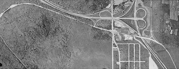
Mystery Foto #22 Solved: A 1955 Aerial View of the Motor Parkway Surrounding Commack Road
This weekend's Mystery Foto provided a unique view of the Motor Parkway.
Mystery Foto questions:
- Identify the location of the aerial
Commack/Dix Hills area surrounding the north/south Commack Road.
- Identify the major roads
Motor Parkway, Northern State Parkway, Sagtikos Parkway, Sunken Meadow Parkway spur (north of the Northern State Parkway), Commack Road, Harned Road (Motor Parkway Commack Spur), and Crooked Hill Road.
- Identify a possible Motor Parkway structure
The roof of the Brentwood Lodge #4 that was located on the Commack Spur was likely in the field east of Commack Road, north of the Motor Parkway.
- What is the date of the aerial? Provide a rationale.
1955. Rationale: The terminus of the Northern State Parkway at the Sunken Meadow/Sagtikos Parkways
Comments (12)
Congrats to Joe Oesterle, Frank Mendyk, Ken Brodsky, Anthony Guadrino, Sam Berliner III, Greg O., Steve Lucas, Tim Ivers, Frank Femenias (see below) and Chris Giffuni for identifying the Commack Road area.
Kudos to Frank Mendyk, Steve Lucas, Greg O., Sam Berliner III, and Anthony Guardino for determining the 1950s date.
Enjoy,
Howard Kroplick
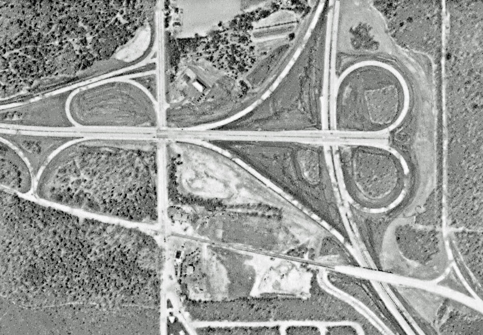
Closeups
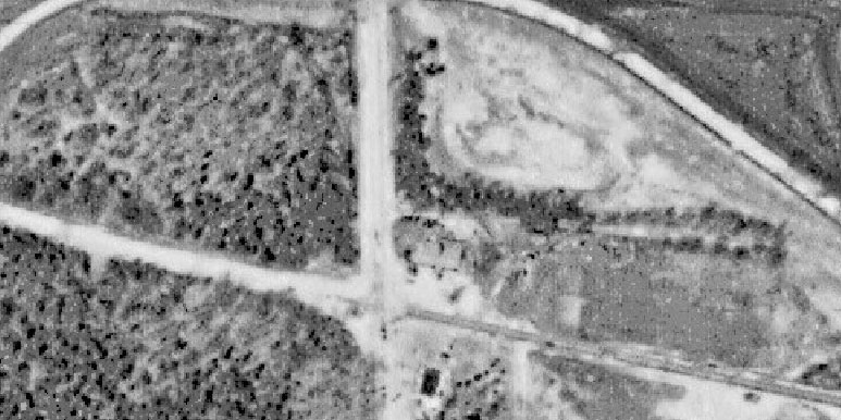
The roof of the Brentwood Lodge #4 is likely in the field east of Commack Road and north of the Motor Parkway.
1964
1964

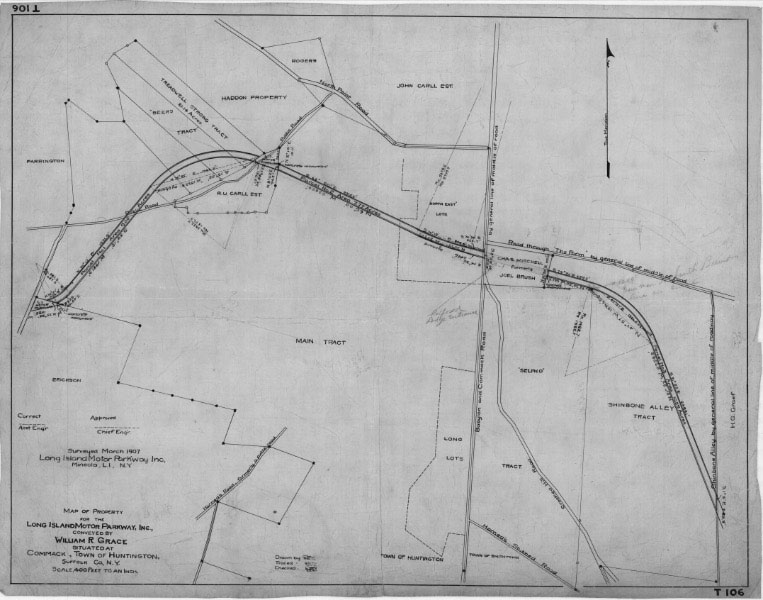
1907 Survey
Femenias' Findings (Submitted by Frank Femenias)
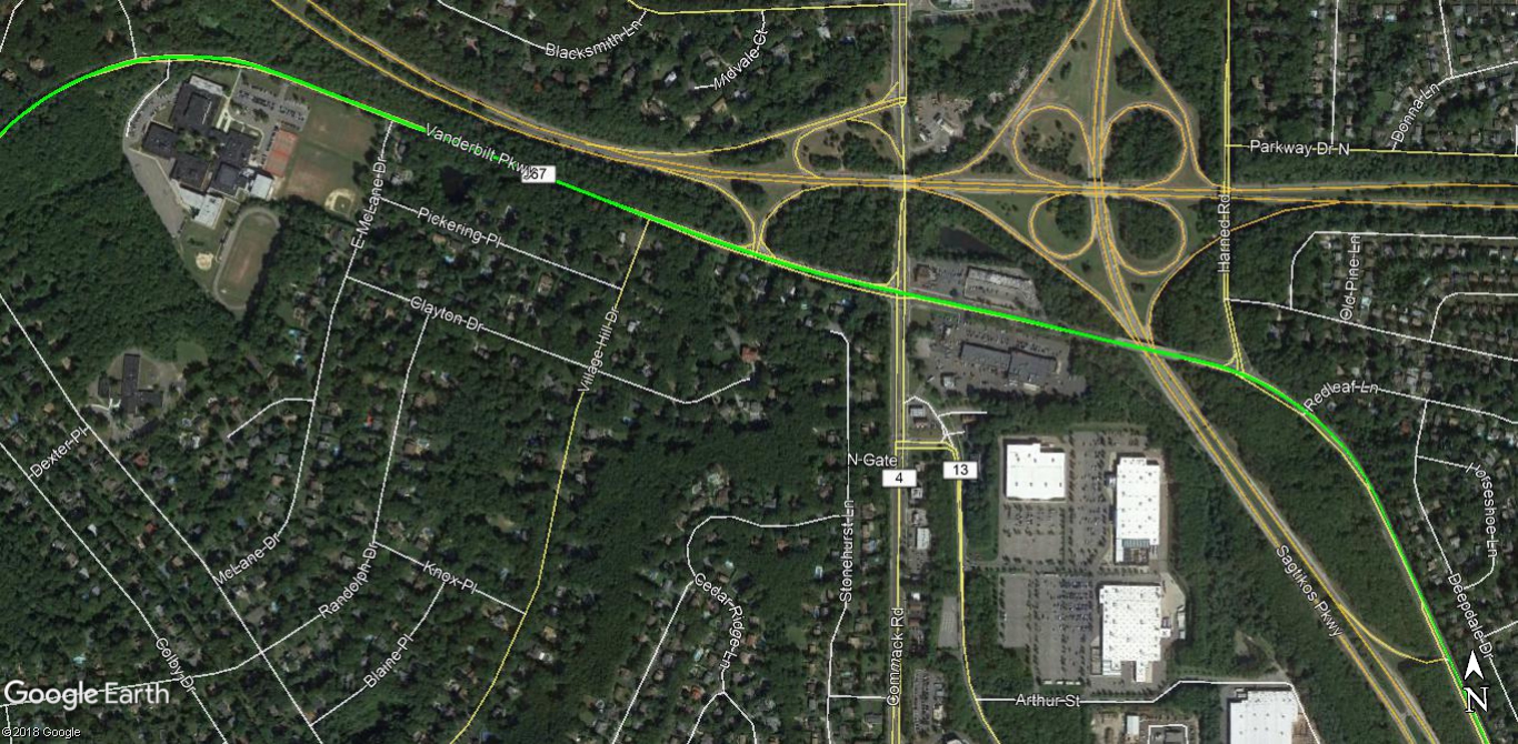
Mystery Foto: Now
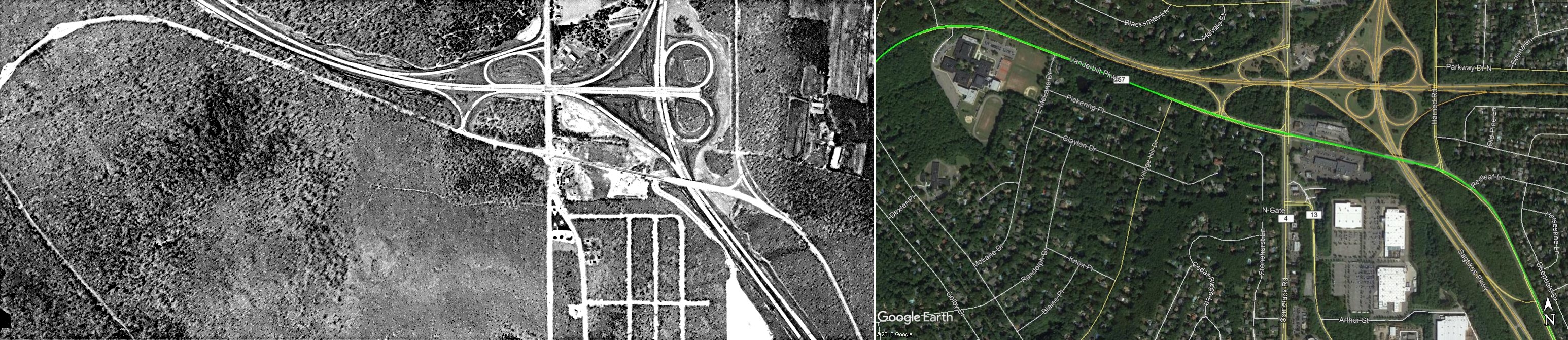
Mystery Foto: Then and Now


Comments
LIMP runs east and west just south of the NSP exit for Commack Rd.
Obviously, the picture is after the building of the NSP, so my guess is sometime in the 1930’s. There is a toll structure on the corner.
Yes, and don’t forget the right side of the picture, with our spur up to Jericho Tpke.
Location - Commack, Northern State Parkway Terminus
Major Roads - LIMP, Northern State Parkway, Sagikos Parkway, Sunken Meadow Parkway spur (north of the Northern State Parkway), Commack Rd, Harned Rd (Old LIMP Commack Spur), and Crooked Hill Rd.
LIMP structures - Bonwit Inn (Old Brentwood Kiosk) 1922-1923 ,Meson Ole ( Brentwood Lodge 1923 an after
Date of photo - 1955 , Sunken meadow spur opened 11/29/54, Mystery Foto #43 11/30/17
1)The location is Commack, NY
2)Major Roads include: Commack Rd, Harned Rd(Motor Parkway Extension to Jericho Tpke), Northern State and Sunken Meadow Parkway
3) Brentwood Lodge Toll Booth structure could be in the picture
4)Construction of the Sunken Meadow Parkway and Northern State was opened to traffic in November 1954. This was the approximate date of this aerial. Also,The date has to be before 1960 since there are no residential buildings showing in most of the photo.
Friday Foto #22
1. The aerial is of the intersection of the Northern State Parkway and Sunken Meadow/Sagtikos State Parkway
2. Aside from showing the State parkways, the aerials shows Vanderbilt Parkway, it’s Commack Spur to Jericho Turnpike (now Harned Road) and Commack Road.
3. Brentwood Lodge #4
4. The date is between 1952 and 1965 because the Northern State Parkway extended to the Sunken Meadow/Sagtikos State Parkways in 1952, but the aerial does not show the Northern State Parkway extension to Veteran’s Highway, which was completed in 1965.
Hi,here I am
Looks so familiar, but just can’t place where it is. I think it’s around one of the shopping malls,don’t know which one though,that’s just a guess. I gues I’ll have to wait until Monday to find out. The weather finally changed for better,sun and clouds in the 80s humid,no rain. I’ll keep intouch as much as I can.
Another easy one, although I freely admit cheating (which I hate) to verify my instant recognition. That’s Commack Road at the (then) eastern end of Northern State Parkway, with (LI) north at the top. Sunken Meadow Parkway heads north from the complex intersection, while Sagtikos heads south at lower right. The picture postdates 1952 when NSP was extended to Commack Road and well-predates 1965 when NSP was fully extended beyond here to Vets’ Hwy. Harned Road (the old LIMP Commack Spur north to the Jericho Pike) runs north just east of the intersection. The diagonal road at lower left is McCulloch Drive. Might that be a toll lodge in the extreme close-up (across the RoW from today’s Bonwit Inn)? [By the way, Harned’s 1840s Commack sawmill, at Harned Road and New Highway, is still in business, run by no less than Doug Harned!] Sam, III
-Identify the location of the aerial
Over Commack North is up.
-Identify the major roads
Vertical roads are Commack Road on the left, Sagtikos Pkwy on the right…The 2 major horizontal roads are the Northern State Pkwy on top, LIMP underneath.
-Identify a possible Motor Parkway structure
The Brentwood Lodge
-What is the date of the aerial? Provide a rationale.
The extension after the Sagtikos to 454 was built in 1965. Pure guess on the date would be mid to late 50’s due to presence of the Sagtikos.
We’re over the eastern Dix Hills / south Commack area with north being at the top of the photo. Besides the LIMP, we see Commack Road, Harned Road, Crooked Hill Road and the then eastern terminus of the Northern State Parkway where it joins the Sagtikos and Sunken Meadow Parkways. It’s possible that one or more pieces of the three versions of the Brentwood Lodge / ticket booth / shanty are visible. Since the NSP extension to Vets Highway is not yet visible and that was begun very soon after the Sunken Meadow section to Jericho Turnpike was completed in November, 1954, the photo is probably from 1954.
An aerial view of the Commack Road/Brentwood Lodge area of thee LIMP
Running north to south in the middle of the aerial is Commack Road.
Horizontally across the middle (Looking like a horizontal pair of scissors) is the Northern State Parkway which ended at the cloverleaf until its extension to Hauppauge in 1965.
I would date the photo to About 1963
Just under the Northern State at a slight left to right diagonal is the LIMP and it crosses Commack Road with the northeast corner showing a building which may have been the Brentwood Shanty #2 and is today’s Bonwit Inn.
Dix Hills / Commack with North up. NSP and SAP both under construction here about 1952. LIMP, Harned Rd, Commack Rd, and Crooked Hill Rd are joining the party. Possible Brentwood Lodge #3 (1923-1928) on the SE corner of LIMP and Commack Rd.
Commack Road, Sagtikos intersection of Northern State. toll house at Commack rd/motor parkway intersection.
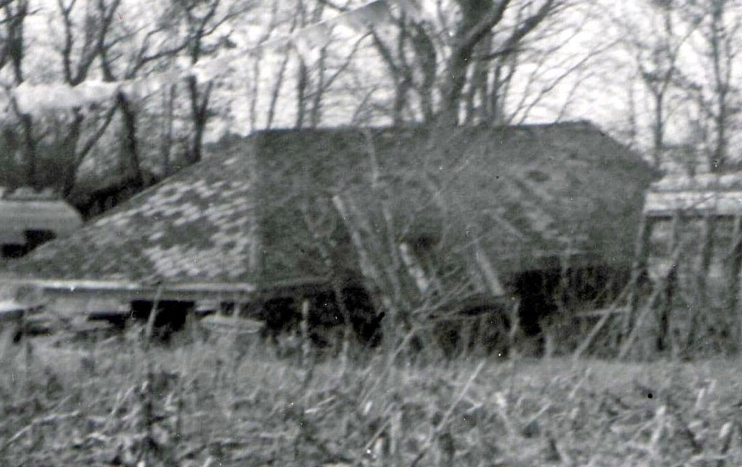
HA- I missed Crooked Hill but no one else picked up on McCulloch (or the little streets off Crooked Hill, for that matter)! However, that lodge roof picture, which I believe should have been credited to Bob Miller, reminds me that I may very well have gotten hooked on the LIMP by an early public lecture by Bob in which he showed that very picture. Please remind me (and probably most every one else) of the story of that lodge’s sad demise. Remember that the Bonwit’s late owners, Charlie and Jimmy Tsunis, always claimed that the lodge site was where their fake well sits today. Sam, III
I was reading through Mr. Velocci’s book concerning the LIMP’s lodges/keepers. It’s thought that Brentwood Lodge #3 eventually became the Meson Ole Restaurant, which was located in the parking lot ( S/E corner of LIMP and Commack Rd/Crooked Hill Rd. ). Does anyone have a good memory of this restaurant? On a Google Streetview, it’s still on location in 2012. But it must have been demolished, because it’s completely gone presently. On the Suffolk County GIS aerials, there looks to be a building there since 1947. This 3rd lodge was similar to the Ronkonkoma Lodge. The building on Streetview sort of looks like a lodge with additions.
Brian - The restaurant had a fire a few years back and was taken down sometime afterwards. The area is now a parking lot behind the McDonalds. I used to go the restaurant a few years back and I enjoyed the food. At the time I did not have any idea that it was connected with the LIMP.
Sam - Yes the streets off Crooked Hill RD. These streets show up on the 1947 Suffolk GIS aerial. They existed all the way up to the time they developed the area for the Home Depot/Walmart shopping center. The roads were never named and the area was never developed. The streets were in a grid pattern and appear to be designed for a housing development that was never built. Does anyone know the mystery relative to these streets?
Brian, you are quite right. Méson Olé‘s then-owner concurred but I never got around to crawling through the attic and such to find hard evidence, like timber branding. Ditto Sempre Vivolo, at 696 Motor Parkway, Hauppauge, which is very much still around. It’s written up on my LIMP History page 2, which never quite got transferred, so I just now finished that up and you can read it, with pix, at <http://sbiii.com/limphst2.html#semprev>. Sam, III
Ted! Welcome back. Hope all is well in the sunshine state. Visit back these parts more often.
Didn’t know the NSP terminated here once. Neat!
If memory serves, someone ripped out the small office space within the lodge to use elsewhere, then setting aside the rest on the field. Bizarre.
Correction, the first time the streets show up are in this weeks mystery photo 1955
Thanks Frank M. and Sam III
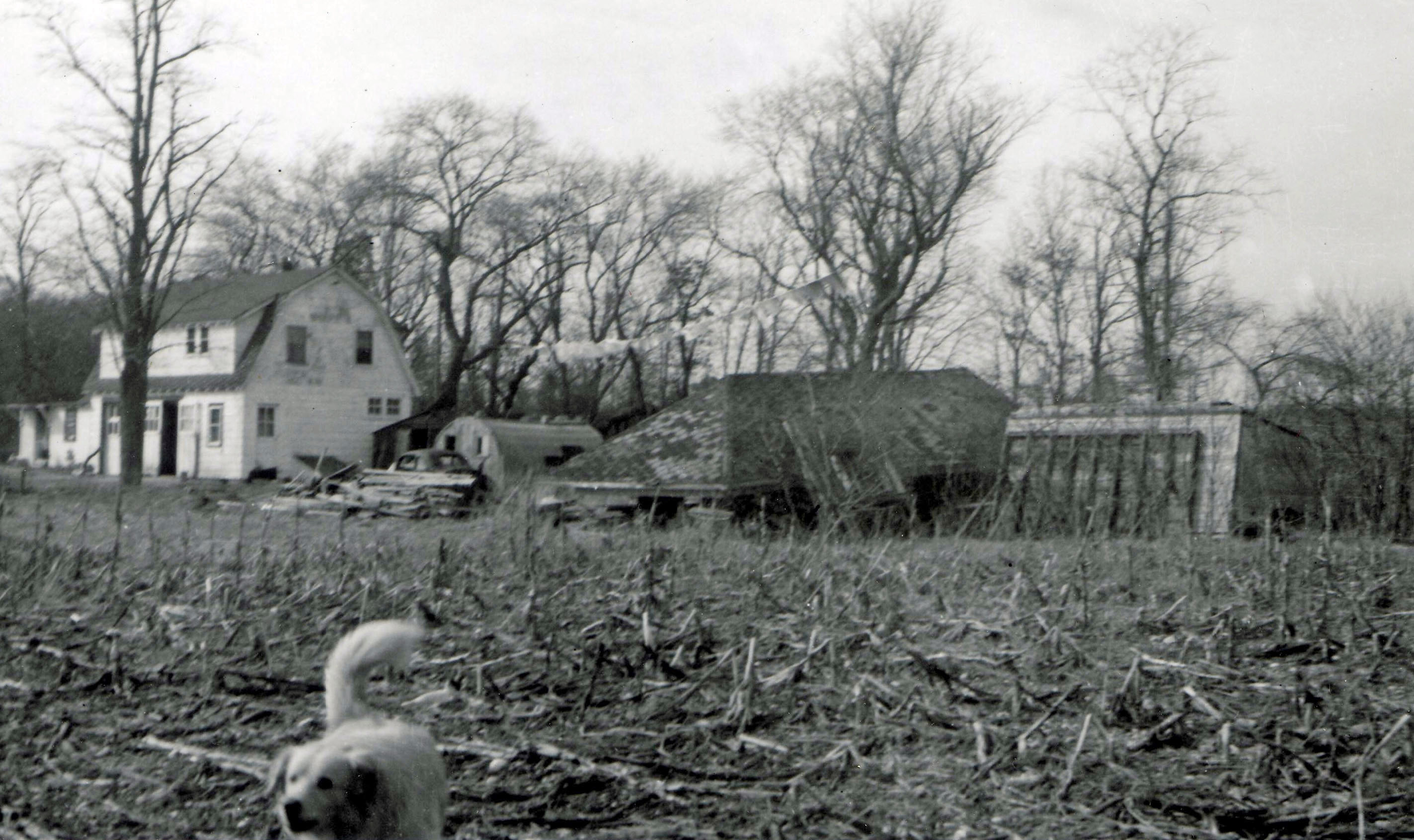
O. K. First off, I asked Bob Miller about the Brentwood Lodge roof picture and he says he “shot looking northeast from the Parkway. It was at the east end of the property of Bonwit Inn, which was a flat spot.” So - what is the hous ein the background? Secondly, I am having some image problems with the remainder of my LIMP History pages, so I restored the easiest, page 4, <http://sbiii.com/limphst4.html>, first, which has a fab. pic. of the Broad Hollow bridge in 1945, among many others. There’s work for you folks to do on the Groundbreaking Ceremony pix there! LIMP History Pp. 0, 1, and 3 to follow. Sam, III
Sam - Location as described, the white house next to the lodge does not appear in satellite photos back to 1994. Bob’s photo may have been taken pre NSP (1952), and house demolished to make way for Moses’ “right of way” for the Sagtikos Pkwy South exit ramp #44. By the way that dog in the photo is in barking mode, I can tell by his eyes. :D
Sam - Oops, Bob’s photo says it’s from 1964. This white house is also mysterious. It doesn’t seem to appear in the 1955 mystery photo as well.