Updated: Mystery Foto #28 Solved: Bethpage’s Important Section of the Motor Parkway & Zorn’s

Brian McCarthy challenged you to solve this weekend's Mystery Foto.
Answers to the Mystery Foto questions:
- What is the location of this Mystery Foto?
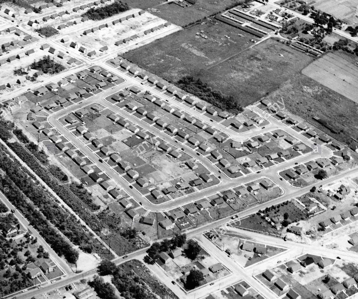
Looking southeast over Bethpage
- Identify the location of the Motor Parkway and the major roads in the aerial
The Motor Parkway runs diagonally across the lower left corner of the Mystery Foto. The remnants of the Jerusalem Road (now Stewart Avenue) Motor Parkway Bridge can be seen at the left corner (white). Broadway is located running diagonally in the upper section. A section of Hempstead Turnpike is in the upper right corner.
- What important event occurred in this section of the Motor Parkway?
The ground-breaking ceremony for the Motor Parkway was held on June 6, 1908 west of Stewart Avenue and north of the Motor Parkway right-of-way- approximately where the first is located in the lower left corner of the Mystery Foto.
- What commercial entity is located in the upper section of the aerial?
Zorn's Poultry Farm of Bethpage located on Hempstead Turnpike. It was a family tradition that we always drove from East Meadow to pick a great turkey from Zorn's. The Mid-Island Hospital (now St. Joseph's Hospital) does not appear to be in the Mystery Foto.
- Date the Mystery Foto. Provide a rationale.
Circa 1951-1953. Rationales:
- The absence of the Mid-Island Hospital buildings (1955)
-No evidence of the Seaford-Oyster Bay Expressway (1958)
-The construction of new homes (1951-1953)
-The Jerusalem Road Motor Parkway Bridge was taken down. It was still standing in 1948 (see below).
Comments (10)
Congrats to Steve Lucas, Tim Ivers, Frank Femenias, Greg O., Joe Oesterle and Frank Mendyk for identifying Bethpage as the Mystery Foto location.
Kudos to Tim Ivers and Frank Femenias for supporting their comments with images and Frank Mendyk and Greg O. for checking house construction data to date the Mystery Foto.
Enjoy,
Howard Kroplick
Close-Ups from Brian McCarthy
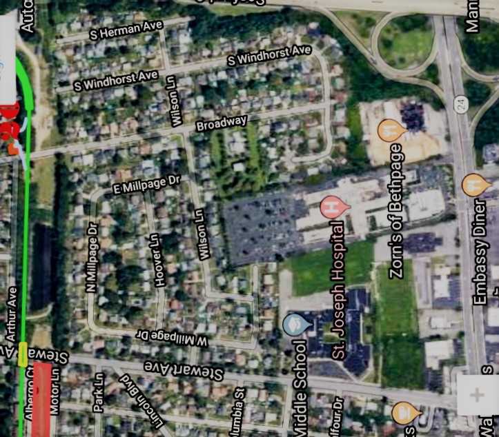
Now: Mystery Foto
Courtesy of Google Earth
Ground-Breaking Ceremony, June 6, 1908
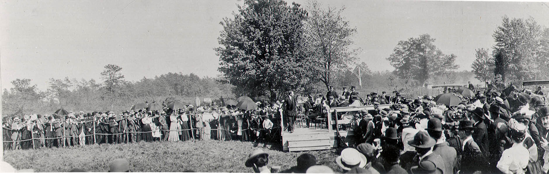
This photo shows the relationship between the speakers' stand and the LIRR crossing sign on Jerusalem Road.
Jerusalem Road Motor Parkway Bridge- 1948
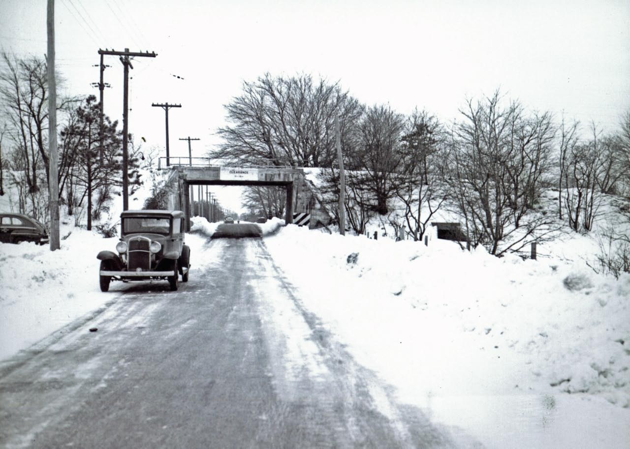
The bridge, looking south, was still standing ten years after the Motor Parkway closed. Photo provided by Bob and Colleen Albertson, courtesy of the Central Park Historical Society.
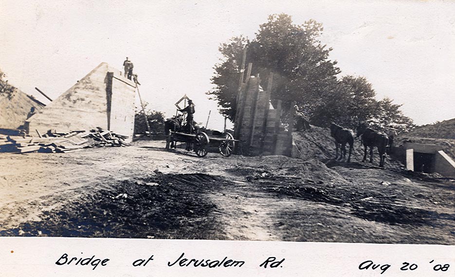
Construction photo taken on August 20, 1908 confirming the above view "looking south'.
Hempstead Turnpike Buildings
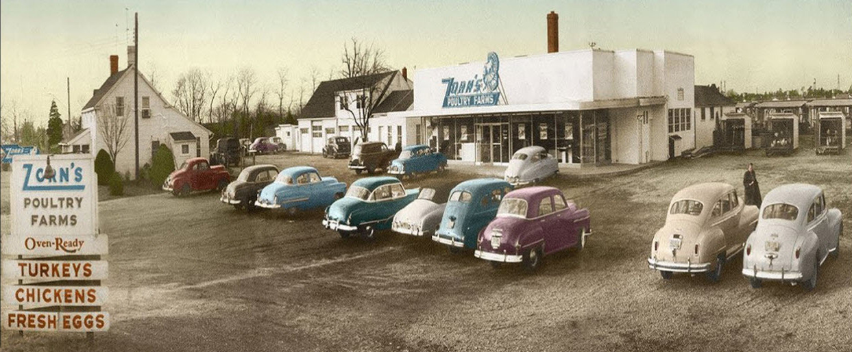
Can anyone identify the automobiles in front of Zorn's?


Comments
This photo is over Bethpage with the remains of the LIMP running diagonally from the middle of the left edge to the middle of the bottom edge. Other major roads include Stewart Avenue, Broadway, Lincoln Blvd., and Hempstead Turnpike. On June 6, 1908, the groundbreaking ceremony for the LIMP took place at approximately the northwest corner of Stewart Avenue and Albergo Court which is in the lower left quadrant of the photo. Zorn’s Poultry Farm is at the top of the photo. Since there appears to be a very small piece of Mid-Island Hospital (built 1955) to the left (east) of Zorn’s yet no evidence of construction for the Wantagh-Oyster Bay Expressway (started 1958), I’ll guess the date between those two years.
Looking southeast in Bethpage over Stewart Avenue
The LiMP is at lower left running diagonally upper left and Stewart Avenue diagonally right.
In June 1908 ground was broken at this location for the Motor Parkway then called Jerusalem Road.
The commercial entity at the top looks like Zorn’s Poultry, established 1940.
Mid Island Hospital (St. Joseph) does not appear in the picture which would indicate the photo predates 1955.
The bridge over Stewart Avenue does not appear (removed in early 50s) so my guess is
The photo is 1954-1955 vintage.
The LIMP bridge here was removed in the early 1950’s. 1953 Historic Aerial displays what looks to be construction of the small hospital, this image doesn’t. This image was taken as late as 1952 then.
Good one Brian! It took two days searching 3 counties but I believe the tricky orientation was the culprit this time. We’re at Lincoln Blvd in Bethpage closely resembling Shiloh Ave in Queens. The bottom center grass field is the site of the 1908 Motor Parkway Ground Breaking Ceremony. Road work started soon after the ceremony ended on June 6. James Spina’s granddad was there. The train must have run through the center of the ceremony site. The photo shows the crowd roped off to the sides, leaving an open area at the center. The Stewart Ave (Jerusalem Rd) bridge has already been removed since the ‘50s. Photographer is looking SE. Motor Parkway is diagonal in bottom left corner missing its bridge, Arthur Ave parallel to LIMP on its left (north), Central RR Row dirt path parallel to LIMP on its right. Hemp Tpke diagonal at the top right corner. New Island Hospital on top, later St. Joseph Hospital. New Island was established in 1999. Is this photo really ca. 1999? It doesn’t appear to be. Looking forward to the answers.
Oh, this is neat; I recognised it instantly as OCR/WestburyAve. and then all sorts of other locales, not ONE of which pans out! Hmm. Good one, Brian! Sam, III
-What is the location of this Mystery Foto?
Looking SW over Bethpage just slightly West of Dead Man’s curve
-Identify the location of the Motor Parkway and the major roads in the aerial
LIMP located diagonally across the lower left hand corner of the photo. Stewart Ave (Lower) and Broadway (Upper) intersecting the LIMP
-What important event occurred in this section of the Motor Parkway?
Groundbreaking for the start of the LIMP construction
-What commercial entity is located in the upper section of the aerial?
St. Joseph Hospital and maybe just a tiny glimpse of Zorns!
-Date the Mystery Foto. Provide a rationale.
1951 based upon construction dates of various homes.
i can only guess the houses built in a place called Levittown, NY. the rest i can not figure out.
LIMP crossing Stewart Ave, just a bit east of the turn north into Dead Man’s Curve.
Location - Bethpage (Central Park) looking southeast over Stewart Ave, LIMP, and LIRR Central Branch
Location of LIMP - the LIMP runs on a diagonal on the lower left side of the aerial
The Central Branch runs next to LIMP
Major Roads - Arthur Ave, Stewart Ave, Broadway, Hempstead Turnpike and Lincoln Blvd. (runs on a diagonal off of Stewart Ave).
Important event- Ground breaking ceremony of the LIMP June 6, 1908, corner of Stewart Ave (Jerusalem Rd) and LIMP.
Commercial entity - St. Joseph’s Hospital
Date of photo - 1953. The house appears to be under construction on Lincoln Blvd. The house was built in 1953.
I also forgot to mention that Zorn’s Turkey farm would be on the top of the photo.
Sorry about that, Frank F. I know how maddening these old aerials can be. Wonder if the original image displayed a larger area? ( found this on Alamy )
If I found this image as “location unknown”, I’d be studying this along with everyone else, Sam III !
The newest car at Zorn’s looks like a 1952 Ford. Most are from the late ‘40’s.
Howard - Was the ground-breaking ceremony truly held north of the LIMP? I always thought it was south on that stretch of grass, the former CRR right-of-way.
Also was the 1948 Jerusalem Road LIMP bridge looking south? There is a culvert to the right of the bridge (east?) in the photo, where today rest a basin to the east of the former bridge.
Never knew about Zorn’s turkey farm but they are still using the same logo on their restaurant signs today.
Brian - Love the mysteries. I had noticed the alamy watermarks on the photo. There are but two that are well hidden. Did you notice them?
Always learning something here, thanks Howard and friends!
__________________________________________________
Howard Kroplick
Frank, it is a good question of where the ground-breaking stand was located. I will post a photo that shows the relationship of the stand with a LIRR crossing sign.
The caption “view looking south” is confirmed on the above August 20, 1908 photo of the bridge with the culvert on the right.
That Zorn’s pic takes me back (NOT aback) but it’s far t0o grainy to do much with. I’ve marked up what I can see with some degree of certainly. 1 is a ‘40 or ‘41 Chrysler, 2 is a ‘46-48 Chrysler product, probably a Dodge, 3 is a ‘50 Chrysler product, probably a Plymouth, 5 may well be a ca. 1952 Mercedes 220 Cabriolet A, 8 is so indistinct that it could be a late-‘40s Ford or a ‘50 Chrysler product, and 10 is unmistakably a ‘49-52 “bathtub” Nash Airflyte (Ambassador or Statesman?). Funny, I don’t recall Zorn’s lot being gravel; I think I’d remember that. Sam, III
I had identified most of the car parked at Zorn’s now leveled will be the new Honda City showroom to be built, the new Zorn’s relocated next to the old site and now opened.
The cars front row right to left are,1-1941 Chrysler, 2-1946-48 DeSoto, 3-1950 Plymonth, 4-1937 Buick, 5-1949 Chevrolet, 6-1951-52 Buick, 7-1950 Olds 98, 8-?, 9-1940 Plymonth? coupe.
The upper row (in front of the store) right to left,
1-1950 Nash, 2-1952-54 Ford, 3-1951-52 Chevrolet Sedan Delivery.
My source, a magnifier, AMERICAN CAR SPOTTER’S GUIDE 1940-1965, and
Google Search mostly, and my MEMORIES OF THEM DAYS!
I may not know LIMP as well as I should but I sure know my Chryslers! I bow to Mark in deep homage! Magnifiers be damned; I missed the horizontal back-up-light/license-plate-lamp housing of #1, clearly a 1941. Oh, the shame. :·( Sam, III [P.S. - #5’s a ‘49 Chevy? Dad had one (briefly). No landau irons! Oh, well.]
Love the site - as for the main image showing Stewart ave. and Hempstead turnpike,
any images showing more of the upper right (vacant land - would be where Stewart and Hempstead Turnpike meet). My house was originally in that are - now the Middle School - basically my house was moved for the school construction in ‘53-‘54
House is going to be 100 years old in 2026 and want to put together some images showing its history/changes. Don’t know if Howard remembers us, but by wife, Lu and I wrote and photographed vintage racing for Vintage Motorsport Mag and others.
Walter
Hey, Walter P - welcome! Folks (better get used to that term, now), as long as this thread has been reopened, what are the rectangular thingies at far right in the Zorn’s parking lot photo, beyond cars 1 and 2; containers or box trailers used for storage? Sam, III
Think I see various fowl in the open sheds you point out, Sam III. Their website - zornsofbethpage.com has a neat timeline with past photos, check it out.
Brian got me going, here! Yes, Zorn’s pix are great, and include a wider view of the lot. Lots more “boxes” - and another convertible to identify! Sam, III