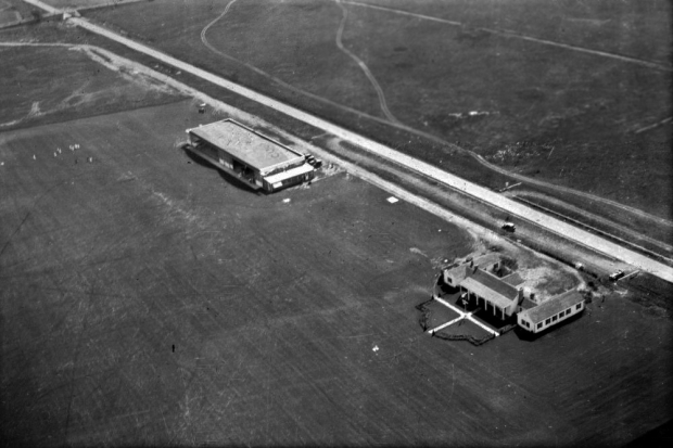
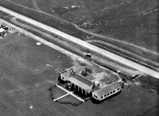
Mystery Friday Foto #28 Solved: An early view of the Long Island Aviation Club and a special parking area within the Motor Parkway right-of-way.
Frank Femenias challenged you to find the special mystery in this Mystery Foto.
Answers to the Mystery Foto questions
Identify:
- The location and orientation of the photographer
The view is looking southeast over the Long Island Aviation Country Club in the Hempstead Plains (now Levittown)
- The Motor Parkway bridge
Jerusalem Avenue Motor Parkway Bridge
- The buildings
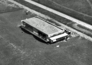
The hangars built in 1929 (left) and clubhouse (right) of the Long Island Aviation Country Club
- The approximate date. Provide a rationale.
Circa 1930. Although the photo is not dated, the dome-roof of the hangar, the pool and tennis court have not yet been constructed.
- Kudos question: What is the special mystery in this Mystery Foto? Hint: Look closely.
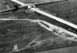
The special mystery in the photo is the parking area to the south of the Motor Parkway posts within the right-of-way. It appears that the Motor Parkway allowed this parking area so that motorists could watch the airplanes.
Comments (6)
Congrats to John Erb, John Cunningham, David Miller, Richard Sloan (the LIAC champion), Brian McCarthy and Steve Lucas for identifying an early aerial of the Long Island Aviation Country Club and the Jerusalem Avenue Motor Parkway Bridge.
Kudos to Brian McCarthy for identifying my mystery within the Mystery Foto: The parking area within the Motor Parkway right-of-way.
Enjoy,
Howard Kroplick
Kudos Answer
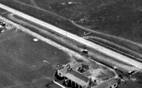
Was this a special parking area within the Motor Parkway right-of way to watch the airplanes?
This aerial (Circa 1937) shows the tennis court and pool of the Long Island Aviation Country Club. Note the parking area within the Motor Parkway right-of-way which now included a stairway.
Both the Mystery Foto and this aerial were posted on the wonderful airfields-freeman.com/NY/Airfields website.
Close-Ups
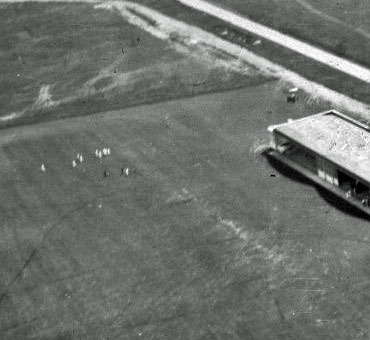
The "People in White". Are they blimp wranglers? Was the Mystery Foto taken form the Goodyear blimp?


Comments
This would be the LIMP, looking southeast over the Long Island Aviation Country Club from what would now be the Levittown-Hicksville border. The LIMP runs immediately to the south of the airfield. The bridge is the Jerusalem Ave bridge. The buildings are the LIACC hangar (left) and clubhouse (right). I would guess the year is 1929-early 30’s, as there is no swimming pool or tennis court built yet, nor are the concrete ramps yet built on the north side of the hangars.
The roof for the hangars is different from what I have seen before. This appears to be a flat roof rather than the vaulted roofs it would have for most of it’s existence. I would assume this is very shortly after being built in 1929.
SE over the Long Island Aviation Country Club in present day Levittown. That is the Jerusalem Ave highway underpass in the top left corner. The buildings are the clubhouse and the hangars. The roof of the hangar covers a building by my house in Bethpage today, I believe. There are no hangar ramps or pool and tennis court in the photo. My guess is early !930’s because of it and the good condition of the parkway.
This is a picture of the Long Island Aviation Country Club. The photographer is facing southeast. The LIMP is on its southern border and the bridge on the upper left of the photo is Jerusalem ave going over the parkway. The clubhouse and the hanger is clearly visible in this picture. However, the absence of the tennis court and pool date this picture closer to its opening in 1929. So I’m going to date this photograph between 1929 to early 1930’s. On a side note to Richard Sloan or anyone who can possibly update. Has there been any progress on erecting the historical marker by the Town of Hempstead near this site?
Great early photo I’ve never seen before of the Long Island Aviation Country Club , in the final weeks of its completion. It’s just north of the Motor Pkwy, visible on the right. The access road (with a car driving to the left/east) is closest to the airport structures. (The photographer in a plane overhead was looking slitely East.
The Motor pkwy bridge is at the top left, probably between where Jerusalem Avenue and cipher Lane or Cool Lane are now located. (I’d love to know more precisely, Frank, as well as where this photo was found!)
The structure at the bottom right is the airport clubhouse. Two of the little add-ones to the East and west wings of the clubhouse have yet to be constructed. The swimming pool and tennis courts aren’t in yet, eithertwo long . So there’s no telling when all of this would be in place. Also mysteriously missing is the curved roof(s) of the hangars . The existing roof shows evidence that the word “Country” has started to be painted. It makes me think that the painting of the rest of the airport’s name was halted because it was decided (or perhaps dictated by the govt) that a curved roof was going to be added. Perhaps this is the mystery ? As to the date of the photo,it’s my guess that it was taken about six to eight weeks prior to the airport’s June 29, 1929 opening.
Nice Mystery Foto, Frank! The aerial photographer took this image viewing southeast, capturing the Long Island Aviation Airport & Country Club in Island Trees NY. From east to west - Jerusalem Ave HWY Bridge over the LIMP, Airplane Hangar & the Clubhouse. Established in 1929, I’ll say this is no later than 1930. Hangar appears to have a flat roof, later images show a split bubble roof. No Tennis Court & Pool is seen, later images show that. Notice the worn paths on both sides of the LIMP, with barriers,parking areas for cars. The road leading to the club on the north side from Jerusalem Ave. Former grandstand etc was here & nearby. Did I stumble upon the mystery within the mystery with my comments?? : )
We are looking primarily southeast over the Hempstead Plains, today’s Levittown. The bridge in the upper left corner is Jerusalem Avenue going over the LIMP. The buildings were part of the L. I. Aviation Country Club with the hangars on the left and the clubhouse on the right. Since the airfield opened in June of 1929 and the roof of the hangar building appears to be incomplete, I think the photo dates from around that same year. The special mystery is that the clubhouse was built approximately where the press Box / officials stand once stood for the 1908, 1909, and 1910 Vanderbilt Cup Races with the public grandstand directly across the LIMP from the press box and the temporary road to the grandstand is still visible.
And I thought that the real mystery was what were all those people (mostly) in white were doing on the field!
David, also another mystery!
The Commissioners of the appropriate county’s Landmark Preservation Commission have said nothing to me about the making of the historical marker for this airport in three years. I their job is an unpaid volunteer one, and I don’t want to say anything to turn them off.last I heard was that they were not thrilled about the way all of their markets looked and were thinking of redoing all of them. I wouldvthink the cost would be prohibitive. Prior to Covid I expected it would have been erected. About two years ago one of the Comissioners — I think it was Joshua Soren—told a reporter for Newsday that he anticipated that the marker would be erected in 2022. Then Covid hit. I don’t know what else to say. Thanx for asking about the sign.
Richard, great work! I hope the historic sign comes to fruition soon and available for all to acknowledge early Long Island history at this particular site. It’s an important site to reveal and document.
The bridge in the photo carried Jerusalem Av over the Motor Pkwy, with future Ciper Ln and Cool Ln very near the bridge proximity. Map below
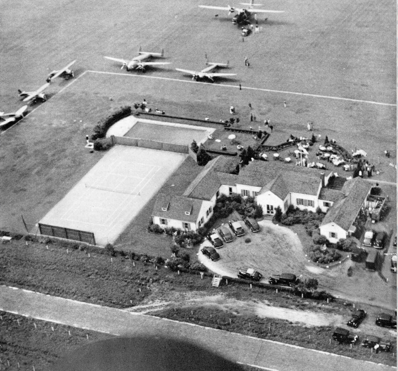
I also thought the mystery was the people all gathered on the ground, as the parking area has been discussed in previous posts. My thought is that this photo was another one taken from a visiting blimp, and that was the ground crew waiting for it to land. If you ever saw the blimps landing at Republic, you know what I mean.
Gary Hammond, I think you could be on to something here. Notice how they are all in white - just as in this photo of a Goodyear blimp at the LIACC. “Blimp wranglers”, to coin a phrase.
Where was this photo found, Frank? ! And thanx for the confirmation about the Jerusalem Ave. bridge on today’s map. (I guess I was right, or at least darn
close, huh?)
Gary, I added a closeup of the possible “Blimp wranglers.” I believe you may be right.
Richard, the blimp photo is on the airfields-freeman website: http://www.airfields-freeman.com/NY/Airfields_NY_LongIs_Nassau.htm
Blimp wranglers/mechanics makes sense. The mechanics wore white at LIACC. LIFE photographer Alfred Eisenstaedt photos
https://www.vanderbiltcupraces.com/blog/article/mystery_friday_foto_15_a_special_day_at_the_long_island_aviation_country_cl
Regarding Brian’s comments of the unpaved sections of the Parkway. We know that the Aviation Club requested an entrance from the Parkway but Vanderbilt turned them down. It appears that Vanderbilt didn’t want to set a precedent. It is obvious that some kind of an arrangement was made that allowed parking on the unpaved portions of the Parkway ROW. In the circa 1937 photo note the stairs over the fence. Also note the double rows of Parkway white cement posts on both sides of the Parkway’s pavement defining the areas autos were restricted to.
With regard to the flat roof of the hanger. There was a fire and an explosion in the hanger early on. My guess is that it was then that the double curved came into being.
Richard, you are on target with the Jerusalem Av bridge location in the mystery photo. Excellent distance analysis from the hangars on your part!
The two blimp photos posted, including the mystery photo, could possibly be part of the same series, even though each photo was found from different sources.
Frank- if you look at the blimp shadow photo and the mystery photo, you’ll see the two parked cars are the same cars and parked in the same spots. The shadow photo also caught a passing car on the LIMP aside from the other two parked cars.
Nice catch Greg! Also the white observation steps in the parking area appears in both photos.
There were at least two black suits on the field in the mystery photo, almost similar to the landed blimp photo.
I believe Gary Hammond is correct
In the landed blimp photo, there’s a woman dressed in white, with a white dog besides her, experiencing the blimp landing at LIACC. What a lucky dog!
Addendum: The woman was also lucky to observe this blimp landing among the rest of the ground crew.
Great photos and info, early 1930’s for sure, the blimp is impressive!