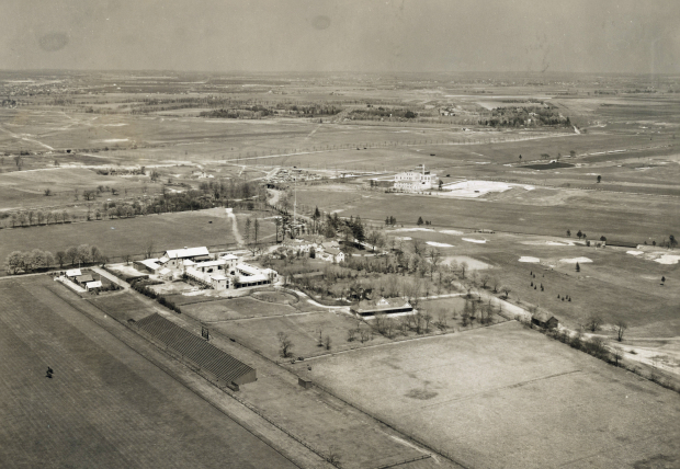
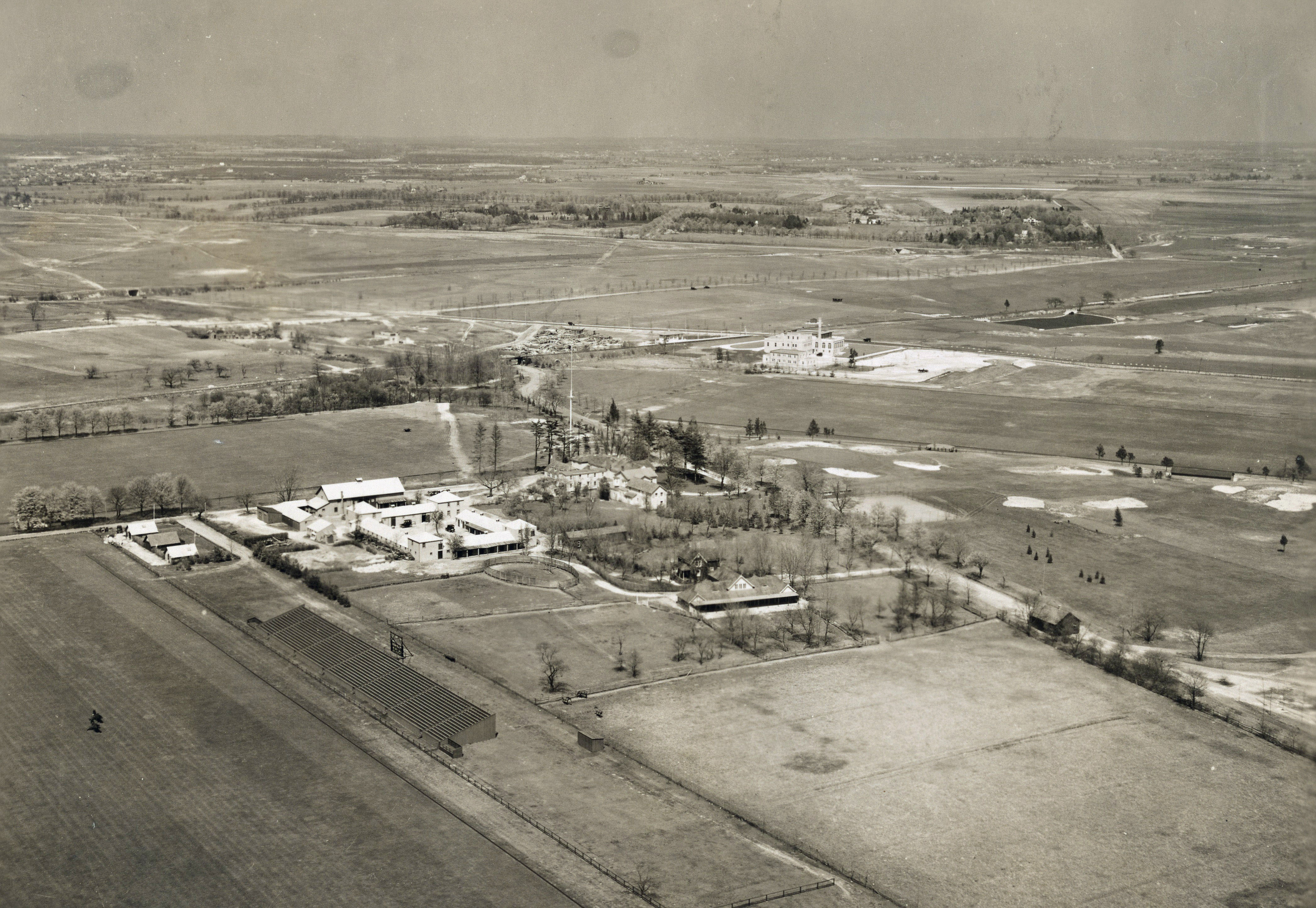
Update #3:Mystery Foto #33 Solved:Spectacular 1924 Aerial of Meadow Brook Hunt Club & Motor Parkway
Author Richard Panchyk challenged you again with another gem from this aerial treasure chest.
Mystery Foto questions:
- Identify the location and orientation of the photographer
Westbury (now Uniondale)/East Meadow looking northeast over the Salisbury Plains
- Identify the major roads.
Long Island Motor Parkway, Stewart Avenue, Merrick Avenue (Whaleneck Road) and Newbridge Road (Bellmore Avenue/Salisbury Park Drive)
- Identify the Long Island Motor Parkway structure(s)
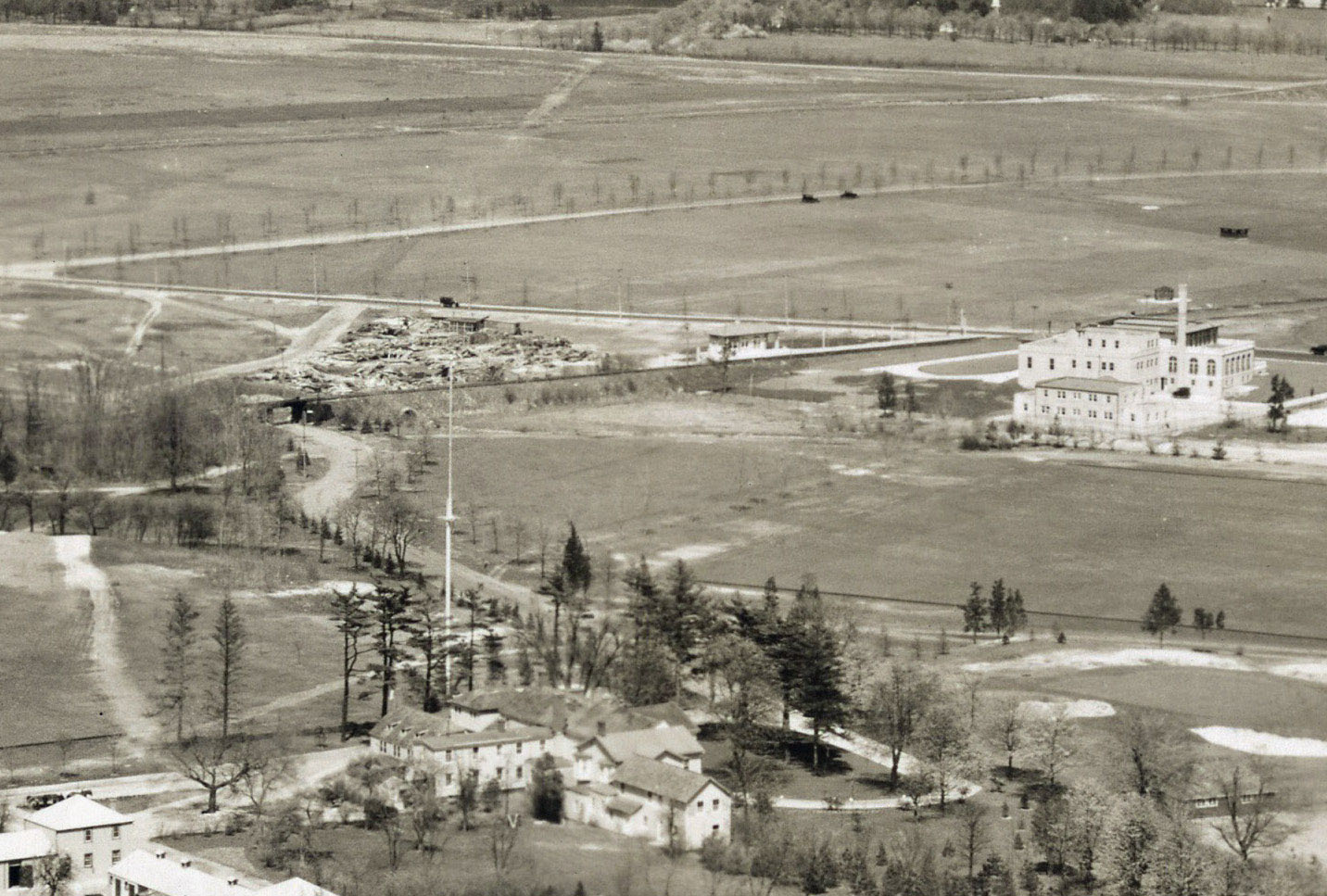
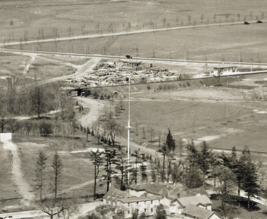
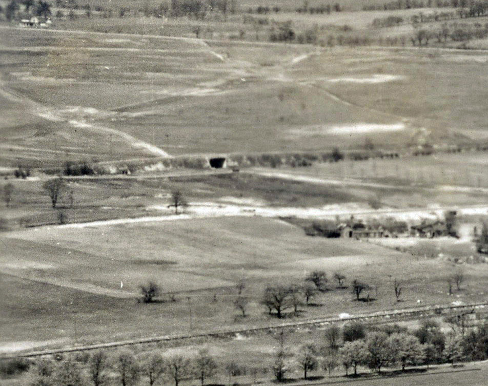
Merrick Avenue Bridge, Meadowbrook Bridge over Newbridge Road, and Stewart Avenue Bridge, and the entrance to the Meadow Brook Lodge. The Meadow Brook Lodge appears to be hidden behind the trees.
- Link the Mystery Foto to the Vanderbilt Cup Races.
The courses for the 1908, 1909 and 1910 Vanderbilt Cup Races all went over the Merrick Avnue Bridge and headed east on the Motor Parkway sen in this aerial.
- Which bridge in the aerial is still standing?
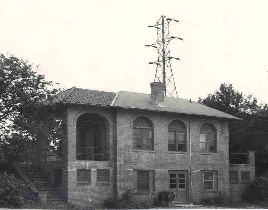
The Central RR Bridge over the entrance to the Meadow Brook Hunt Club and Polo Grounds is still standing in the woods off of the Meadowbrook Parkway.
- Identify the railroad track and railroad station.
Central Railroad of Long Island and the Salisbury Plains Station.
- Identify the other significant Long Island buildings.
This is probably the best aerial view of the clubhouse, polo grounds, stables and associated buildings for the Meadow Brook Hunt Club and Polo Club.
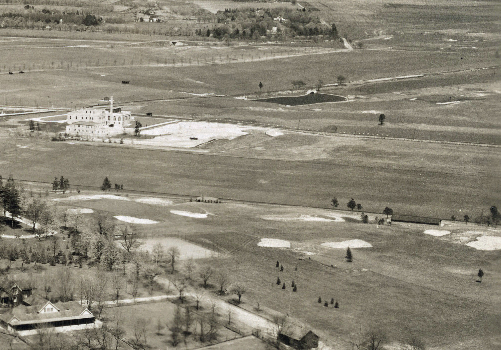
The large clubhouse for the Salisbury Country Club can be seen near the top of the aerial off Merrick Avenue.Identify the golf courses.
Meadow Brook Club and Salisbury Links
- Which future First Lady lived on a property seen in the Mystery Foto?
Eleanor Roosevelt lived on her father's Half Nirvana estate on Salisbury Drive and Valentine's Road.
- Identify the property located on the upper right section of the aerial.
The Ladenberg Estate which the Motor Parkway needed to circle around.
- What is the date of the Mystery Foto? Provide a rationale.
The aerial is dated 1924. The newness of the Salisbury Country Club clubhouse and Salisbury Plains Station.
Update: Lee Chambers has added additional kudo questions and highlighted close-ups:
- What was the purpose of the two clusters of buildings and the rectangular building?
- Is there significance to the large vertical mast?
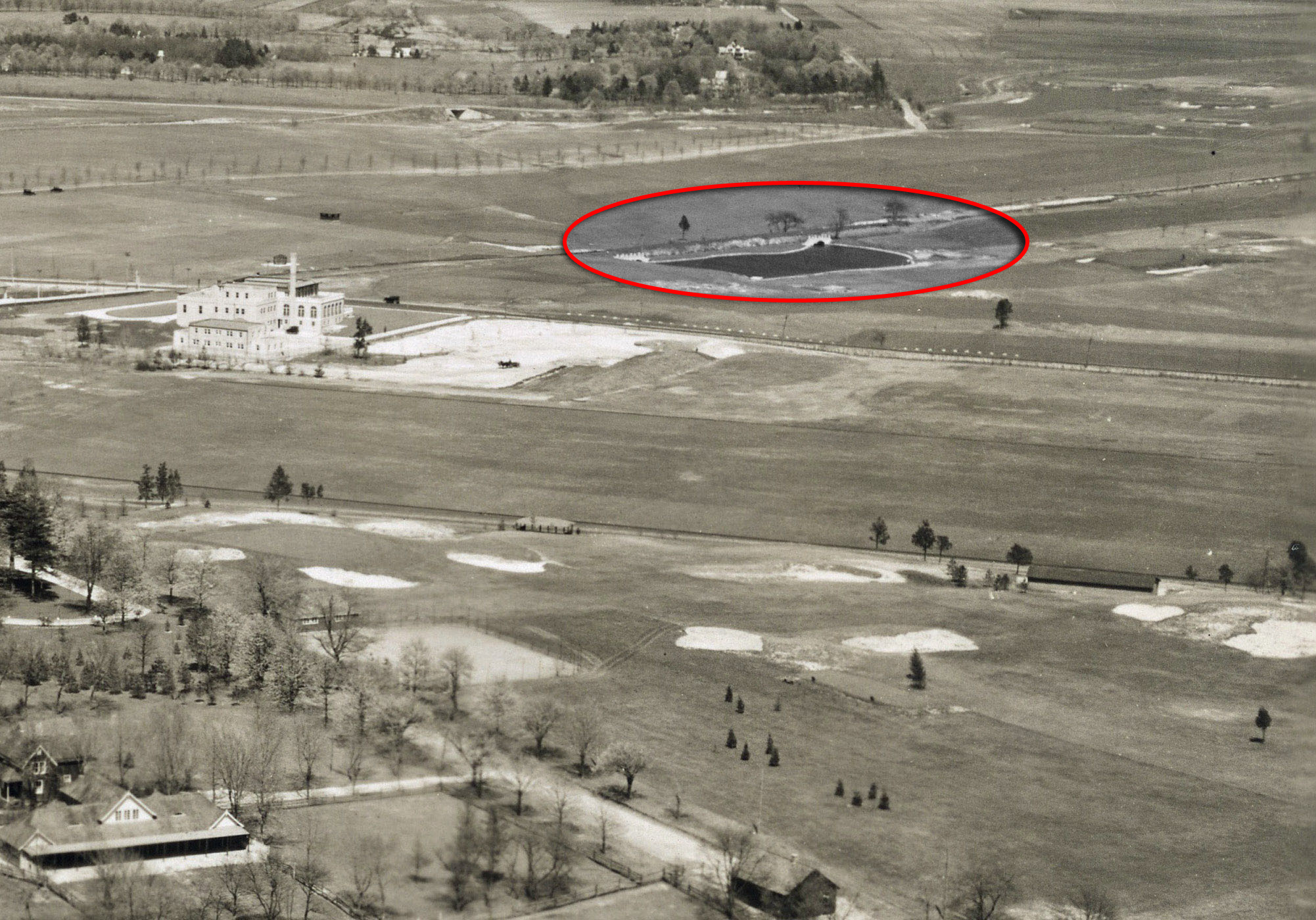
- Was the body of water in the Mystery Foto naturally recurring or man-made? Is it still there today?
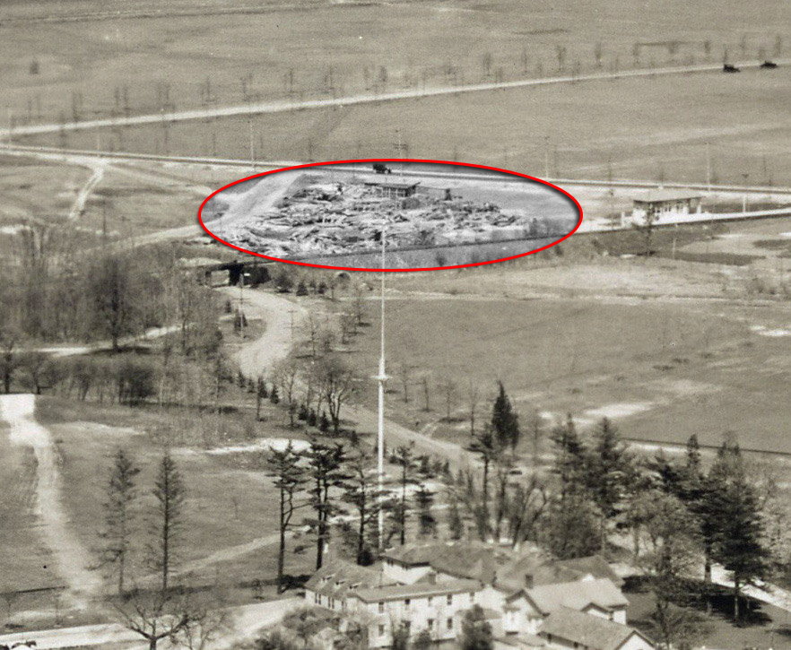
- Was there a debris field to the left of the building seen near the top?
See below Lee Chambers' close-up and comments for possible answers.
Comments (10):
Congrats to Greg O.,Lee Chambers, Art Kleiner (see Kleiner's Korner), Frank Femenias, Steve Lucas, Tim Ivers, and Michael LaBarbera for identifying the Westbury/East Meadow location.
Kudos to Lee Chambers for providing all the fun details on this wonderful aerial.
Check out the town historian of North Hempstead on CBS Channel 2 News tonight.
Enjoy,
Howard Kroplick
Lee Chambers' Close-ups
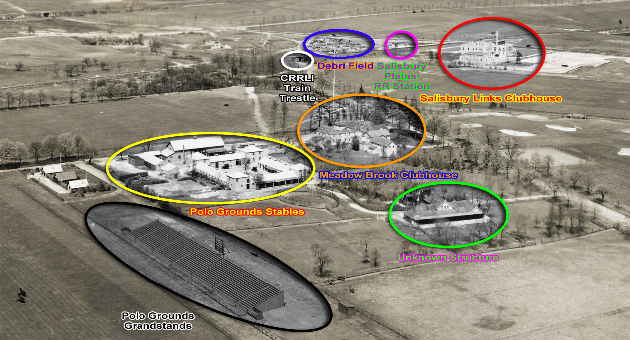
Lee Chambers: Striving for accuracy, based on the comments submitted thus far, I have labeled each of the structures of interest accordingly:
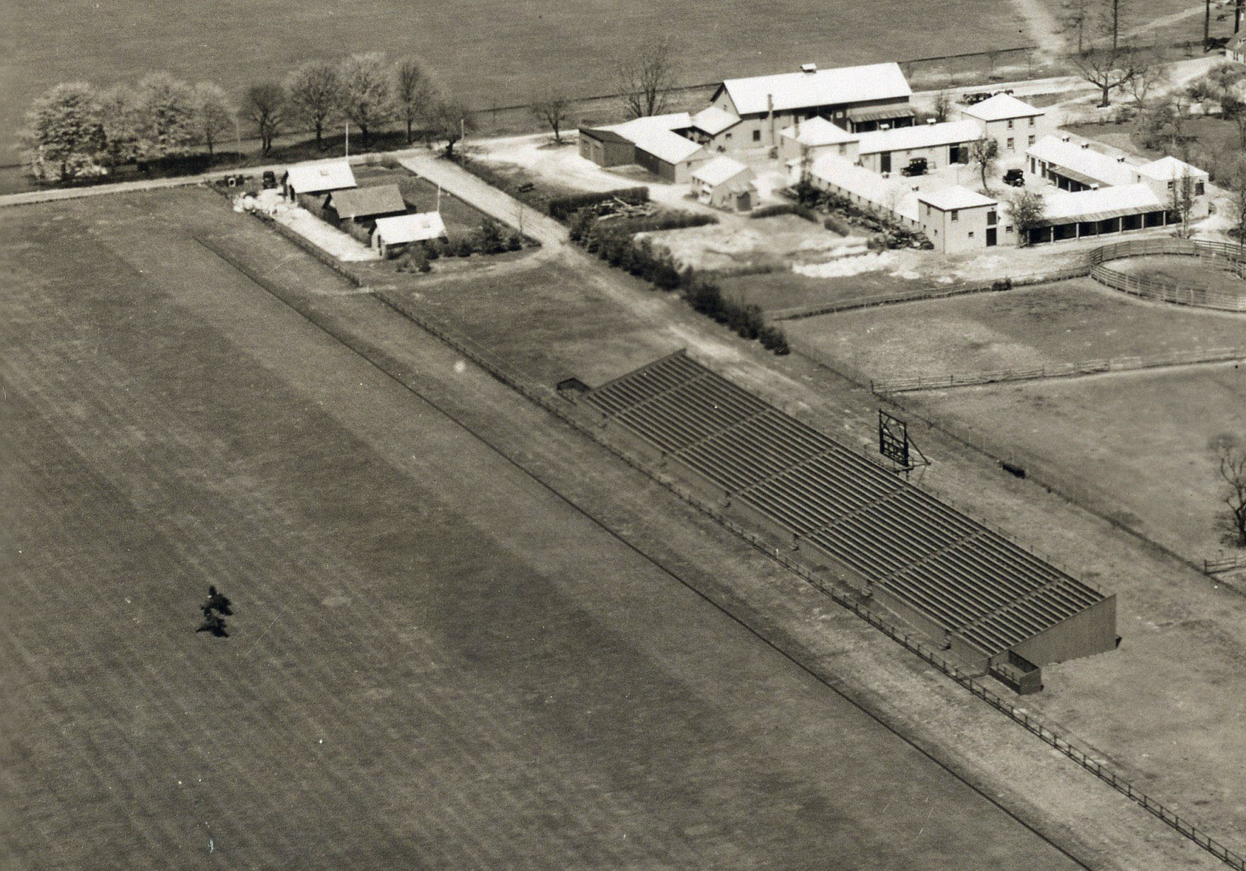
Black - Polo Grounds Grandstand. There were two of these with the 'matching' one on the other side of the field not in sight. Combined, they held 40,000 spectators. The LIRR ran special trains through what became Mitchel Field, dropping passengers off on a low cinder platform immediately East of what became Endo Blvd. From there, pedestrians cold easily walk over to the field. Even that was not enough. Additional trains also ran on the main line to Westbury with a shuttle bus running down to the field.
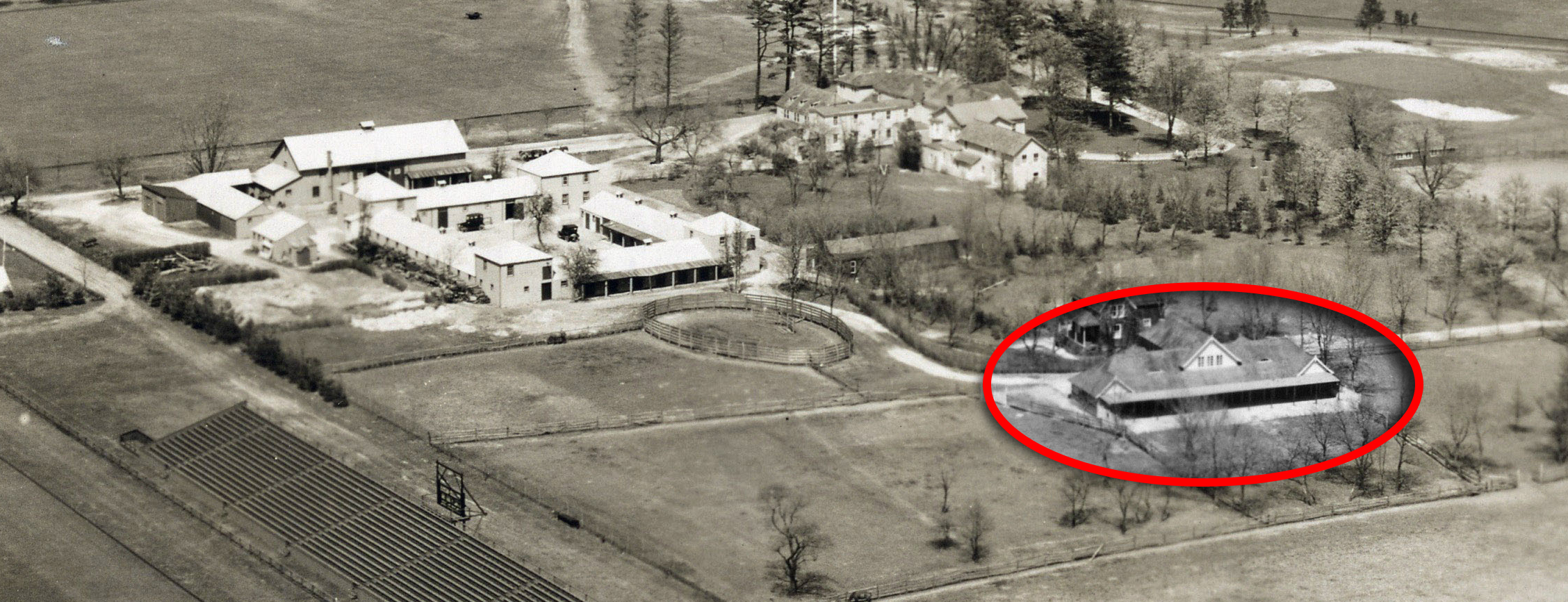
Yellow - Polo Grounds Stables. The corral is obvious. Could the two story buildings have been administrative offices? The layout of the cluster of buildings resembles a self contained compound. The road running adjacent to it may have eventually become part of Perimeter Road, portions of which still exist today. As a point of reference, the James Fuller (he lived two houses down from me on Rice Circle) Physical Plant at NCC (the first building of the new campus constructed) would be in the field just to the North of here.
Orange - Meadow Brook Clubhouse. Meadow Brook Club Road winds down from the train trestle to the main entrance with the stately white columns in the front which are not seen in the photo as the viewpoint is from the rear. These buildings stood as late as the early '50's and were torn down for construction of the Meadowbrook Parkway extension in 1955.
Green - Unknown Structure. What was this? My guess is it was Polo Grounds related. Dormitories for visiting teams? Food for spectators? There appears to be a private home behind it. Did the innkeeper live there? It likely was not related to either of the golf courses as each of them had their own facilities for patrons.
Red - Salisbury Links Clubhouse. Is this correct? The golf club's property extended to the west of Merrick Ave.? Meaning golfers had to cross a busy thoroughfare to get to the various courses to the East? Or was vehicular traffic not that much of a concern back then?

Chambers' Treasures
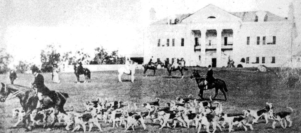
Fox hunt at Foxhall Keene's Rosemary Hall in Old Wesbury
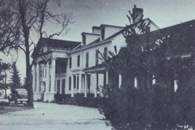
Meadow Brook Hunt Club- 1930s
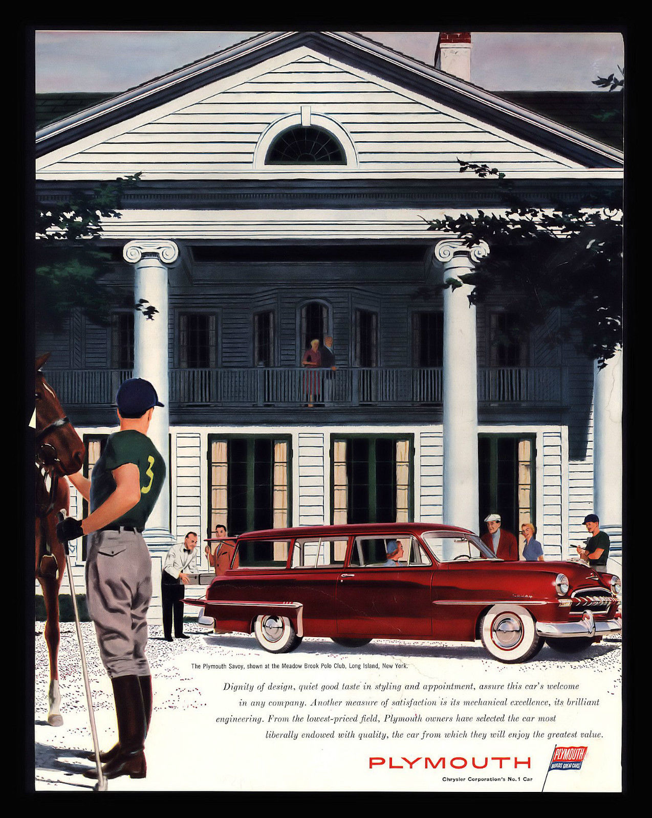
Plymouth Ad - Meadow Brook Polo Club -1955
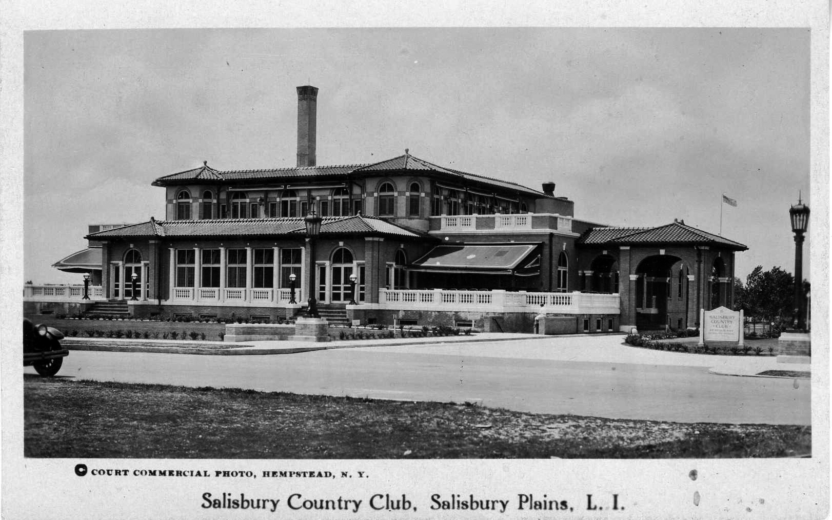
Salisbury Country Club

Salisbury Plains Station-1923
Salisbury Plains Station-LIRR
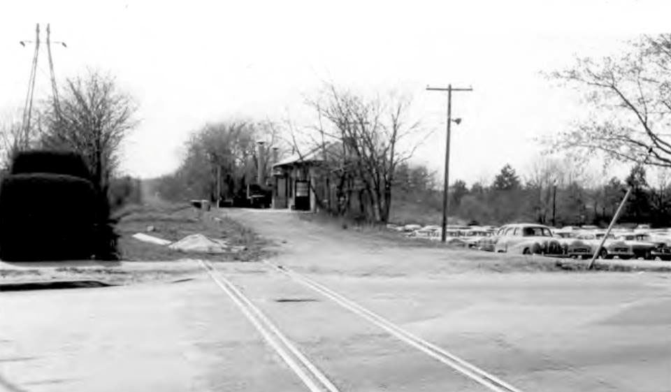
Salisbury Plains Station-1955
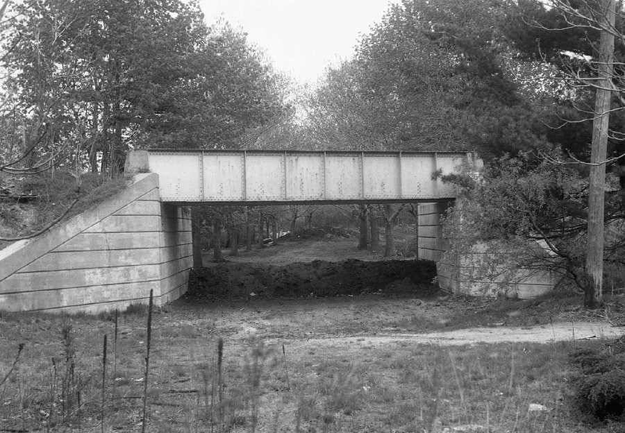
Central RR Bridge over Meadow Brook Club Road-1955 Courtesy of Dave Keller
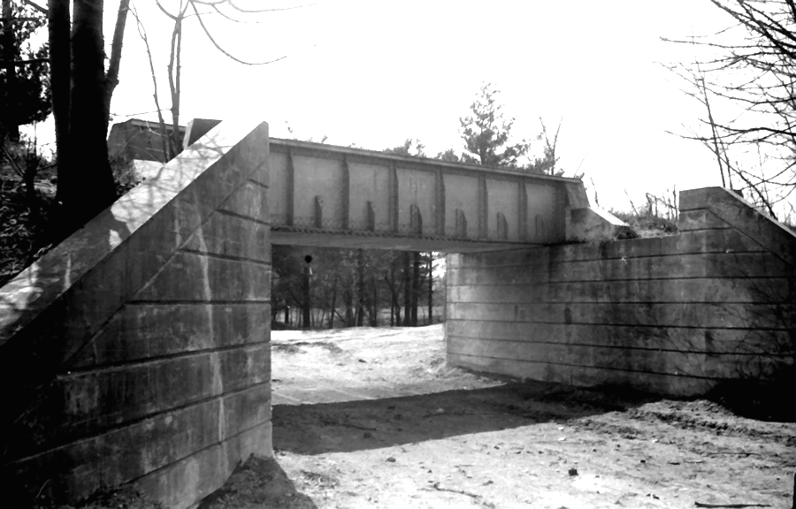
Central RR Bridge over Meadow Brook Club Road- 1964 Courtesy of Dick Makse
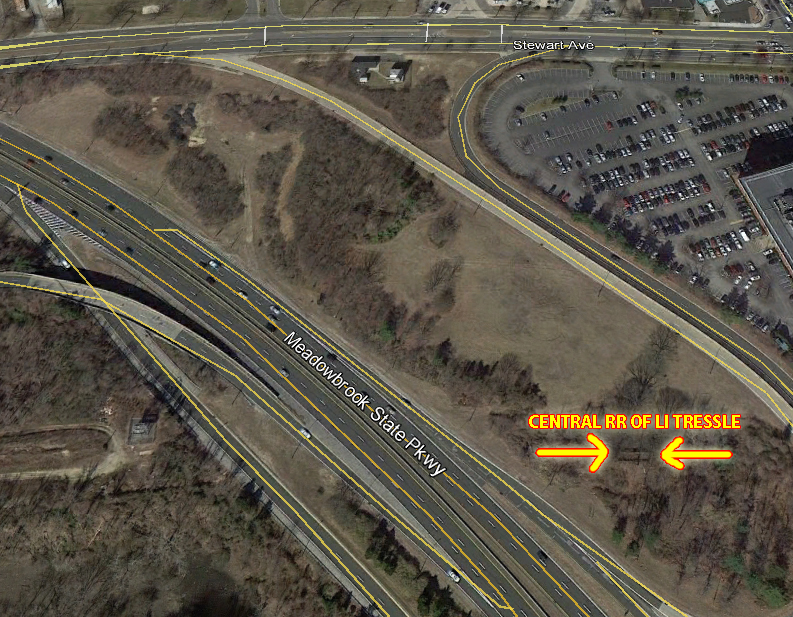
Location of Central RR Bridge
Close-Ups
Kleiner's Korner (Submitted by Art Kleiner)
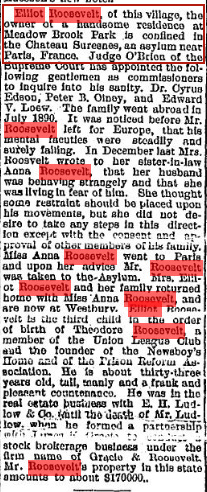
The Long Islander, August 22, 1891
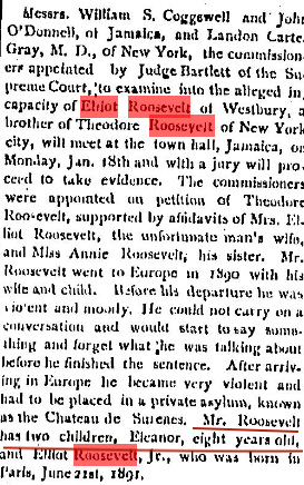
The Long Islander, January 16, 1892
Robert Spinzia, 2010
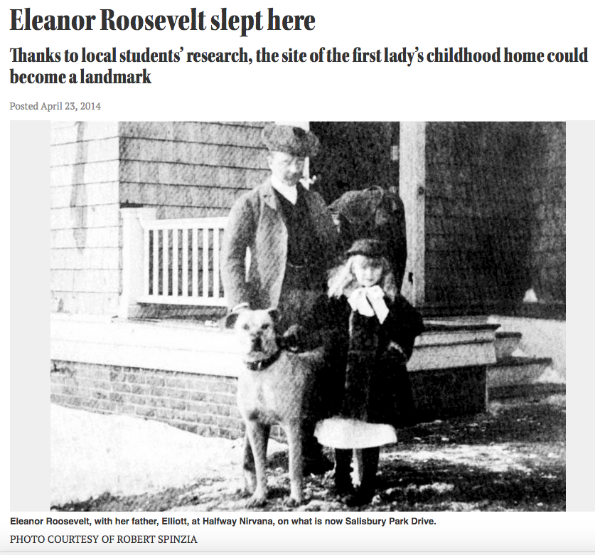
Long Island Herald, April 23, 2014
Femenias' Findings (Submitted by Frank Femenias)
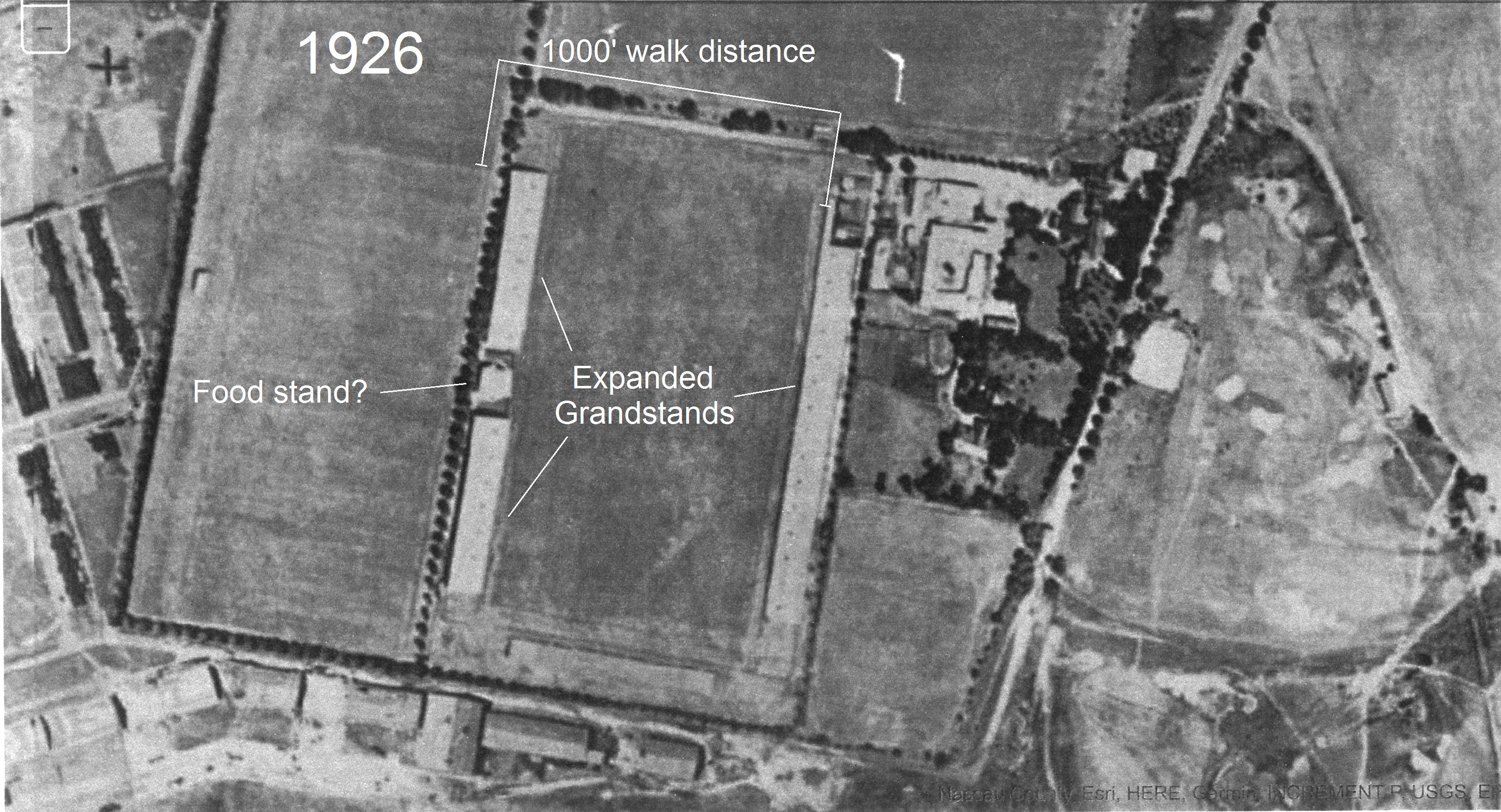
Meadow Brook Hunt Club 1926


Comments
-Identify the location and orientation of the photographer
View looking Northeast at Salisbury/Westbury above the Meadowbrook Polo Field
-Identify the major roads.
LIMP, Merrick Ave, Stewart Ave, Salisbury Park Dr,
-Identify the Long Island Motor Parkway structure(s)
Merrick Ave PW Bridge, “Meadowbrook” parkway bridge over Newbridge Avenue (Bellmore Road), Stewart Avenue Bridge
-Link the Mystery Foto to the Vanderbilt Cup Races.
1908, 1909, 1910 VCR races used this portion of the LIMP
-Which bridge in the aerial is still standing?
The Central RR bridge still there buried in the exit ramp of the Meadowbrook Pkwy.
-Identify the railroad track and railroad station.
Central RR- Salisbury Plains RR Station
-Identify the other significant Long Island buildings.
Meadow brook Polo Club, Clubhouse for the Salisbury Country Club
-Identify the golf courses.
Salisbury Links, Meadow Brook Golf Club
-Which future First Lady lived on a property seen in the Mystery Foto?
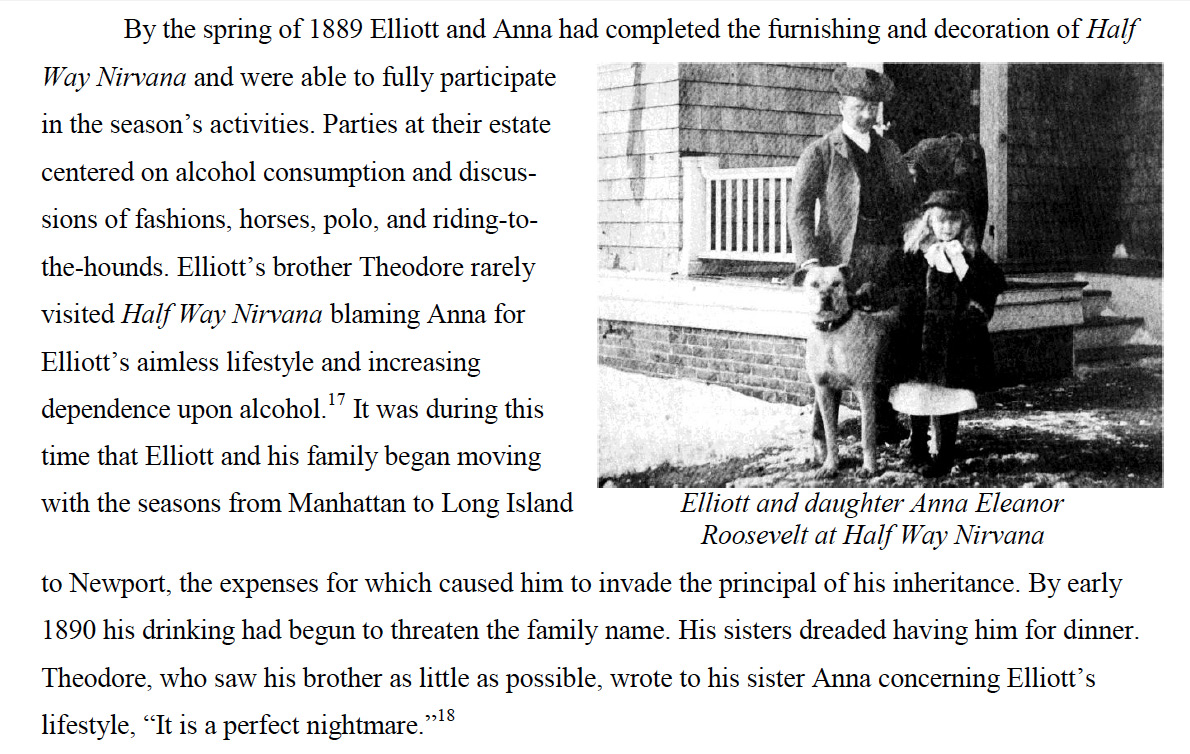
Elliott Roosevelt’s 10-acre home Half Way Nirvana was located near the intersection of Valentines Road and Salisbury Park Drive (then called Newbridge Road.)
-Identify the property located on the upper right section of the aerial.
The Ladenburg Estate
-What is the date of the Mystery Foto? Provide a rationale.
Just a guess judging by vehicles, early 1930’s
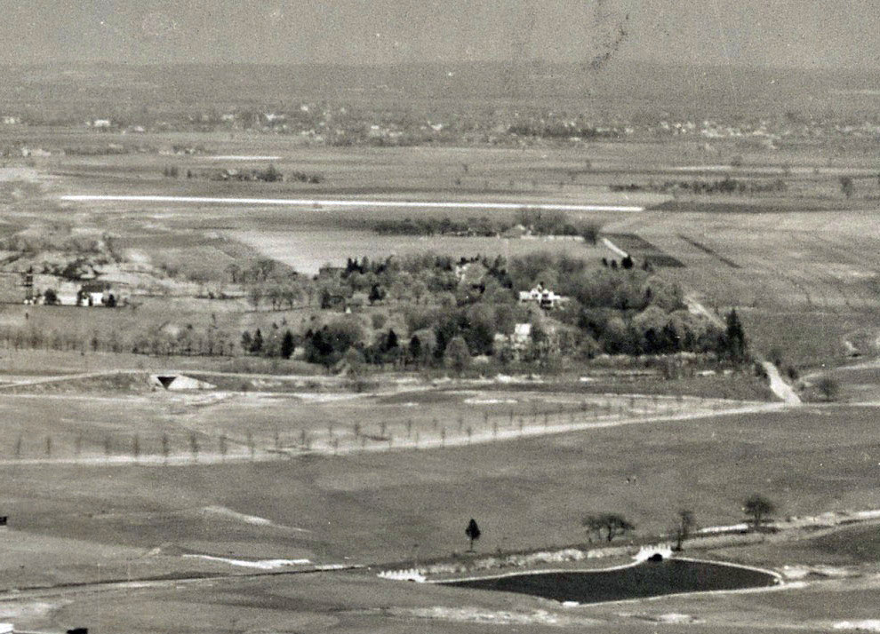
Aerial photo facing Northeast, overlooking East Meadow, specifically the Salisbury subdivision adjacent to Westbury.
Close up photo #1 shows one of the two grandstands at the Polo Grounds. That field would be used years later as NCC’s baseball diamond, prior to the construction of the new campus in the ‘70’s. Ancillary equine support buildings including a circular corral for the horses can be seen behind the stands.
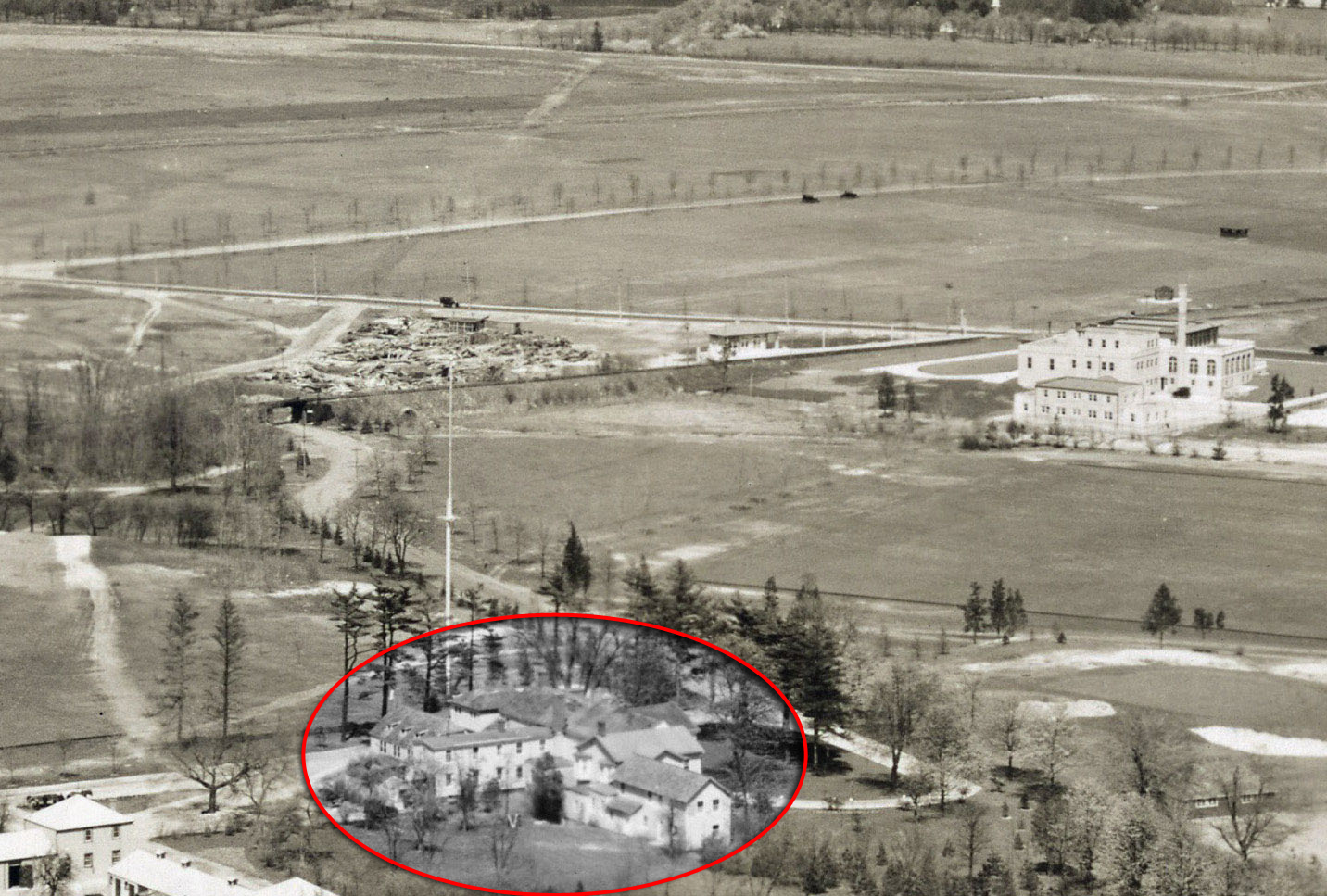
Photo #2 shows the Meadow Brook (two words) Golf Club. Nearby is the Salisbury Plains station of Alexander Stewart’s Central Railroad of LI (later acquired by the LIRR). To the left of the station, the surviving bridge which still exists today is visible in the woods inside the transition loop leading from Eastbound Stewart Ave. to Northbound Meadowbrook (one word) Parkway.
Beneath the bridge, Meadow Brook Club Road can easily be seen curving up to rendezvous with Merrick Ave. (Whaleneck Road). The rail line was severed in 1955 during construction of the extension of the Parkway from the Northern to Southern State Parkways, though passenger service to Mitchel Field ended in May, 1953 (other than the nightly shuttle for Roosevelt Raceway).
North of the rail line, running West to East, the tree lined continuance of Stewart Ave. can be seen along its original alignment through the Salisbury Golf Club, later to become Salisbury (Eisenhower) Park. Beyond that, the LIMP can faintly be seen running parallel to Stewart Ave.
Off in the distance, the LIMP bridge over Merrick Ave. can be seen. In front of it, a car appears to be turning left onto the key shaped entrance road leading to the toll booth.
This is by far the most detailed photograph I’ve come across of the extreme Northeastern corner of the Mitchel Field environs. The pathway of roads in the area is the clearest to date. Likewise, buildings in the area adjacent to the Polo Grounds are more prominent than in any other photo from the same area.
I am particularly interested in identifying these buildings (other than the Meadow Brook Club and Salisbury Plains station) and their purpose. Any assistance in that regard would be most welcome!
East Meadow/Wesbury, looking northeast over Salisbury park, Meadow Brook Club
LIMP, Stewart Ave., Merrick (Whaleneck) Ave., Salisbury Park Road
Merrick Ave. Bridge, Bellmore Ave. Bridge, Salis. Park Dr./Wantagh Pkwy. Bridge
1908, 09, 10 Cup Races
Current bridge shown - Salis. Park Drive/Wantagh Pkwy., bridge; the train trestle leading into the Meadow Brook club still exists off of the Meadowbrook Parkway.
Central RR and its Salisbury Plains station
Salisbury Links Clubhouse, Meadow Brook Club
Salisbury Links, Meadow Brook Club Golf course
Future first lady - Eleanor Roosevelt who lived as a young girl on her father’s estate, Half Nirvana near the corner of Valentine’s Road and Salisbury Park Drive.
Ladenberg Estate
Late 1920, early 1930s
This early aerial is in East Garden City over future runway 23 Mitchell Field looking NE, with Meadow Brook Hunt Club in the foreground. Tons of stuff in this amazing super-sharp aerial. Labeling everything would flood the photo with text.
Tree-lined Merrick Ave (Post Ave, Whaleneck Rd) and Stewart Ave cutting through future Eisenhower Park (Salisbury Park). Old Newbridge Ave (Salisbury Park Dr) once running through the park as well. Central RR also through the park. The former entrance to the Meadow Brook Hunt Club is curved just south of the RR bridge, making this photo’s date 1927-1937. This entrance would eventually be straightened out by 1938.
A few firsts here. This is the sharpest aerial view yet of the Central RR bridge (still standing). There appears to have once been a straight, diagonal roadway connecting the Club entrance at Merrick Ave to Salisbury Park Dr on the other side of the park. The RR track in the park once traveled over a culvert by the lake. This lake today is more than triple in size. Where’s the water coming from? Rare shot of the RR station off of Merrick Ave, and the Ladenburg oasis farm in the park. I cannot see her windmill nor the Meadow Brook racetrack in her backyard. It goes on and on…..
Motor Pkwy structures are Meadow Brook Lodge, Merrick Ave Bridge, Newbridge Ave Bridge, and Stewart Ave Bridge, all in plain sight! Rare view of the Meadow Brook lodge entrance ramp ascent in comparison to the parkway just behind it.
1908 - 1910 VCR races used this section.
Salisbury Links, Eleanor Roosevelt, I give up
looks like the area of hillside ave west of the current meadowbrook pky (not in picture) . there is a golf course noth of hillside ave and the old motor pkwy is east-west on the northern part of the golf course.
We’re over Westbury looking northeast. In addition to the LIMP, major roads include Stewart Avenue, Merrick Avenue and Bellmore Road (Newbridge Avenue). LIMP structures include the Meadowbrook Lodge, Merrick Ave. bridge, Bellmore Rd. bridge, and Stewart Ave. bridge. This section of the LIMP was part of the course for the 1908, 1909, and 1910 V. C. Races. The LIRR Central Branch bridge is still standing although hidden in the trees about 200 feet east of today’s Meadowbrook Pkwy. The Salisbury Plains station can be seen just east of the bridge. Just south of the LIRR bridge is the Meadowbrook Club clubhouse. The rectangle building could be the stable. Along with the Meadowbrook Golf Club, you also have the Salisbury Golf Club. The estate of Emily Ladenburg (Oasis) can be seen in the upper right where future First Lady Eleanor Roosevelt lived as a youngster from 1888 to 1892. The Salisbury Plains station opened in 1923 and it looks fairly new so I’ll guess 1923 or 1924 for a date.
Looking northeast over the eastern Garden City and Salisbury area in 1932.
The buildings in the center are the Meadow Brook Hunt Club; to its right the Meadow Brook links.
In the distant right is the Coldstream Clubhouse on Merrick Avenue opposite the the lake (still there) in Salisbury Park.
Lower left shows a partial view of the Meadow Brook Polo Field grandstand.
The road running left to right across the very top is the LIMP, with the Merrick Avenue bridge visible at left and in the distant right is the bridge over Salisbury Park Drive, and the LIMP curve around Mrs. Ladenberg’s property, where Mrs. Eleanor Roosevelt lived for a period of time.
Good one! Absolutely nothing clicks (yet)! There is no place where a major body of water lies directly NNE of the LIMP RoW. I’d guess the original image was cut off there. The RR station sure looks like the Central Branch’s Meadowbrook Station, which would make the middle-left-to-lower-right diagonal Whaleneck Road and the one beyond the station Post-cum-Merrick Avenue but nothing else jibes. I give up (in disgust, knowing full well this will be a “Well, DUH!”). Sam, III
I forgot to ask if anyone else sees a horse running north to the left of the grandstand. Sam, III
Aerial view looking NW toward Westbury from Hempstead Tpk by in Uniondale by the Coliseum. Over Stewart Avenue right to left and Merrick Ave top to bottom on an angle. LIMP structures west to east are Merrick Avenue Bridge, Newbridge Ave Bridge and Stewart Avenue Bridge. Train station is the Salisbury Station and the bridge that is still standing is the Central RR bridge west of the station (now filled in to its neck by the Meadowbrook Pkwy). The building along Merrick was the Salisbury Links Country club and the Lake at Eisenhower is still there fed by the Meadowbrook brook. I do not know thats a good question if its a natural feed. The neighborhood north of Stewart Ave along today’s Salisbury Pk Drive was home to Elanor Roosevelt as a child. The 2 clusters of buildings were the Meadowbrook Club and the mast was its flagpole (guessing). I think date the picture to be 1924 after the Salisbury Clubhouse looks new and the debris field may be just that after its construction.
Bad day - I KNEW I’d be embarrassed. For sad “last” shots of the MB Clubhouse and the MB Station, see <http://sbiii.com/lirrcrr1.html#slsbrypl> and of the CRRofLI bridge, see <http://sbiii.com/lirrcrr3.html#crrbridg>. Sam, III
Update: Lee Chambers added several treasures to the post.
Lee - Fantastic photo submission. Thank you! It appears the fire hydrant by the Salisbury Plains station is the same as the ‘74 photo posted on Sam Berliner’s website (courtesy Art Huneke). The distance in between is the same.
http://sbiii.com/lirrcrr1.html#slsbrypl
Sam - Previously, I was unable to form a shape for the object(s) by the grandstand. At first I thought birds, but their size were too large in comparison to the grandstand seating. Horses now sounds more likely, two heading north with their necks casting shadows pointing to the west. Nice catch! Free, runaway horses on the spacious field, how lucky they were.
Lee - your Green Unknown Structure sure looks like a stable to me; there are a number iof similar such along the Gold Coast. Frank - look again; up close - that is a horse and rider/jockey at upper right as clearly shown by its/their shadow at lower left (Howard can post an extreme blow-up or I can send one). All - sorry if I scrambled Meadow Brook and Salisbury Plains - someone please enlighten me. Sam, III
The Plymouth ad is 1953 not 1955.
Sam,
If the green structure were stables, any guess what the cluster of buildings in yellow was used for?
Anyone in the know - Was the Salisbury Country Club along Merrick Ave. and adjacent to the train station part of the golf course proper?
Or was it an independent entity that happened to be right across the street?
Lee - ??? You already have the Yellow marked as “Polo Grounds Stables”. My reason for pegging the Green as such applies to Yellow as well. Notice the extensive and deep overhangs; that feature is typical of LI (and other) stables. As to the flat-roofed rectangular building on Merrick Ave., I always (perhaps incorrectly) knew it as the former Meadow Brook Club clubhouse, with the Salisbury Plains RR station across the CRR tracks directly to its north <http://sbiii.com/lirrcrr1.html#slsbrypl> - updated with satellite view). I’d be happy to correct my page if so advised knowledgeably. Sam, III
Sam,
What I mean to say is, those grandstands were capable of holding upwards of 40,000 spectators for matches. Wouldn’t it seem logical that some sort of facility for food, beverage and restrooms for them be somewhere in the immediate vicinity such as in the green circle?
Also, how likely would stables be constructed so close to a private home, just a few feet away?
But for the sake of argument, let’s say the building in the green with the deep overhangs is indeed stables. Then the buildings in yellow would not also be stables. What are they? Does the resemblance to a compound have any significance?
The proximity of the corral to them led me to believe they were the stables and the building in the green was something else.
I love the 1923 Salisbury Plains Station pic, one car line!!
Lee - the W, S, and E segments of the quadrangle in Yellow appear to be stables; the rest are probably maintenance buildings for the whole huge club complex. The residence N of the Green stable is most likely the complex superintendent’s home. As the complex grew, adding stables is not at all unlikely. Necessaries (facilities) are very like to be in the three buildings at the NW corner. Sanborn valuation maps would be a great help here. Sam, III
Whoops, Lee; that’s NOT the MB clubhouse in the Plymouth ad - one less story and the fan window is too close to the door lintel (plus wrong roofline). {My, how these threads grow - just great!] Sam, III
To the left of this photo unseen is another grandstand equal in size, about 700 ft across the other side of the field. The three small buildings north of the grandstand shown could be a strategic location for all spectators to use. Are those two antennas in the rear of the white roofs in 1924? Perhaps his/hers restrooms with food in the center
Just two years later, the grandstands would be expanded covering most of the field. Sending attachment
Update #3: Frank Femenias has added a 1926 aerial of the Meadow Brook Hunt Club.
Frank - you’re right, the original grandstands were not large enough to support 40K patrons. But the newer, larger ones were. Those two antennas in the rear of the white roofs in 1924 might have been flag poles.
Sam, you are are also correct. Later photos beyond Frank’s 1926 aerial shot show additional buildings behind the easternmost grandstand.
Zoom in on the artwork for the Plymouth ad though. The caption says, ‘The Plymouth Savoy, shown at the Meadow Brook Polo Club, Long Island, New York’. I suspect the artist took a few liberties in re-creating the building.
Caption on the about fox hunt was corrected.