Mystery Friday #35 Solved: A View Along the Long Island Motor Parkway in Melville
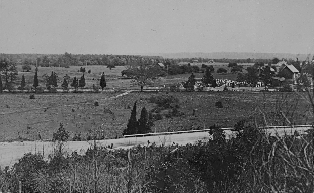
This weekend's Mystery Foto documented a distinctive view of the Motor Parkway.
Answers to the Mystery Foto questions:
- Identify this section of the Motor Parkway.
View looking east to Walt Whitman Road and Broad Hollow Road in Melville. The Motor Parkway in this section was built on a plateau.
- What toll lodge was the closest to this section?
West of Huntington Lodge.
- Identify the other roads in the Foto.
Walt Whitman Road with Broad Hollow Road in the background.
- What other historic landmark can be seen in the Foto?
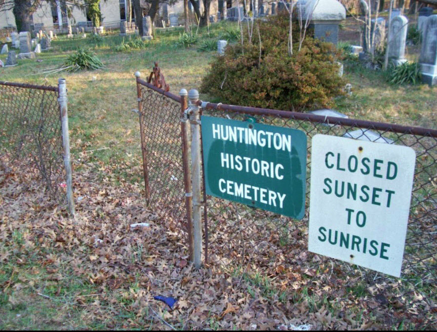
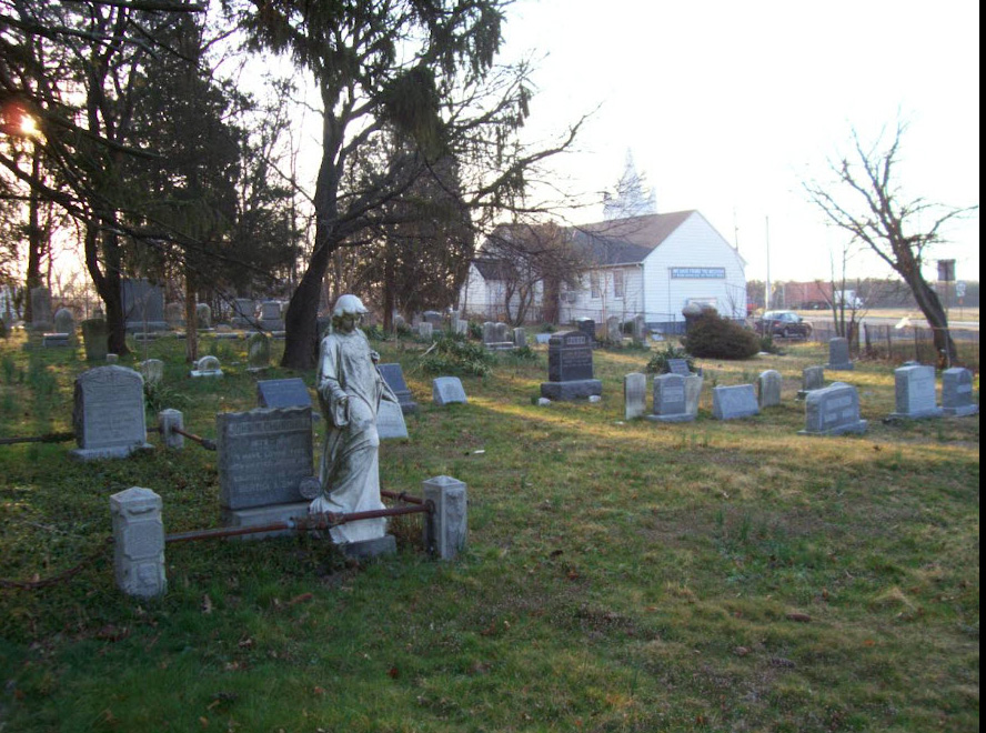
The Huntington Historical Cemetery (AKA Lower Melville Cemetery) can be seen in the middle of the Mystery Foto. The cemetery was associated with the Lower Melville Methodist Episcopal Church located to the south. Among the prominent Long Island families buries here are the Smiths, Van Nostrands, Baylis, Ketchams, and Bedells. The church is now The Shalom Center.
Comments (13)
Congrats to Michael LaBarbera, Joe Oesterle, Sam Berliner III, Greg O., Brian McCarthy and Frank Mendyk.
Kudos to Sam Berliner III, Brian McCarthy and Frank Mendyk who supported their answers with jpegs.
Enjoy,
Howard Kroplick
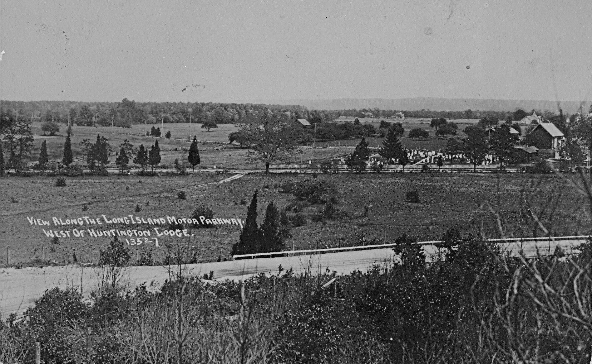
The caption on the photo reads " View Along the Long Island Motor Parkway West of Huntington Lodge."
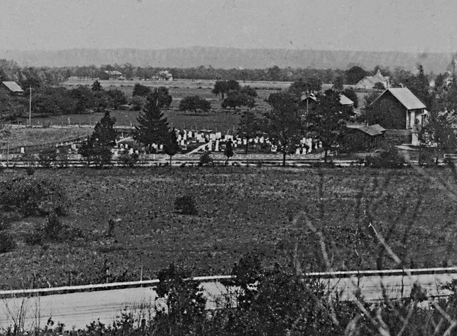
Close-Ups

1930 Aerial
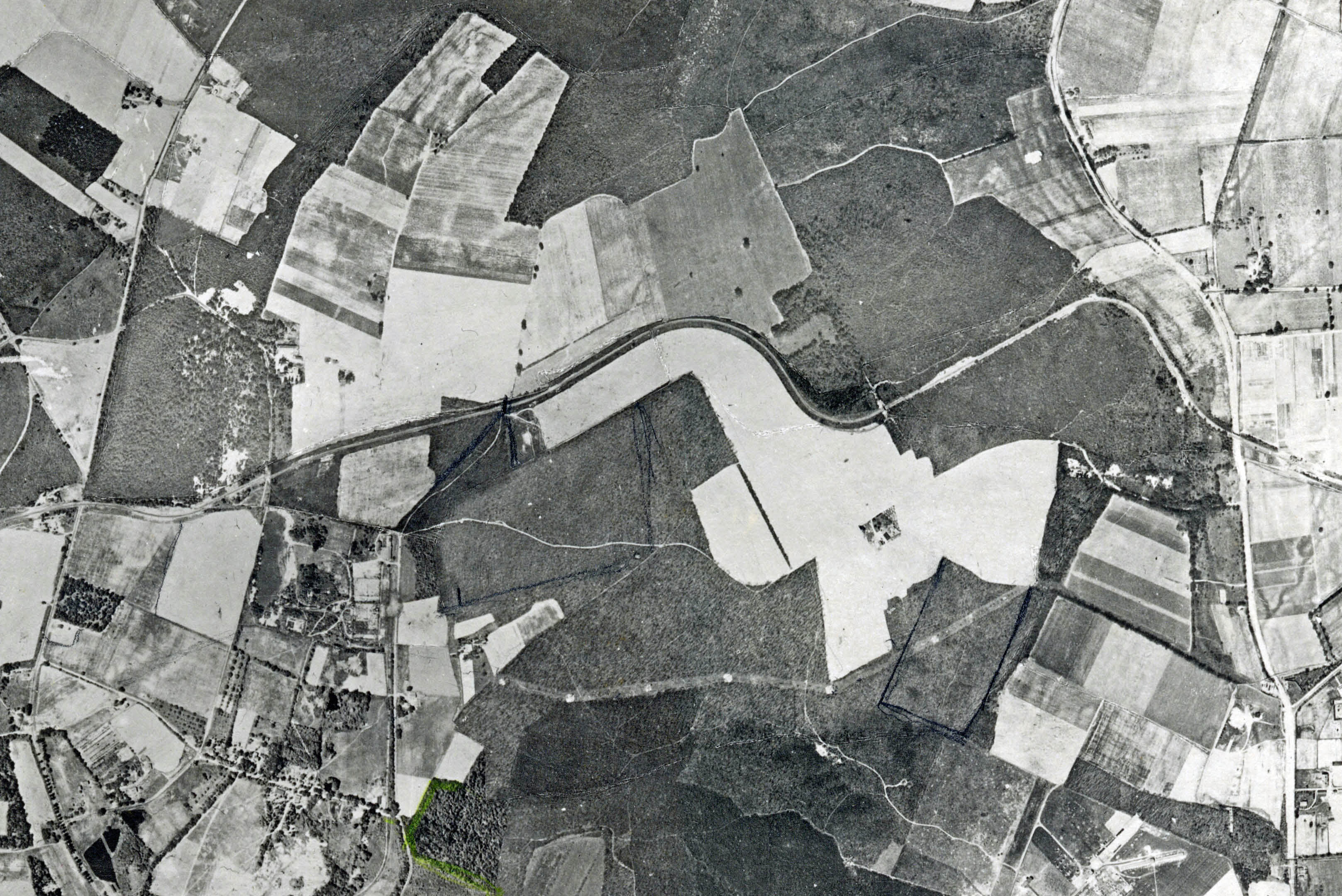
This 1930 aerial of Bethpage and Melville includes the location of the Mystery Foto and five Motor Parkway bridges.

Broad Hollow Road and Walt Whitman Road can be seen on the far right.
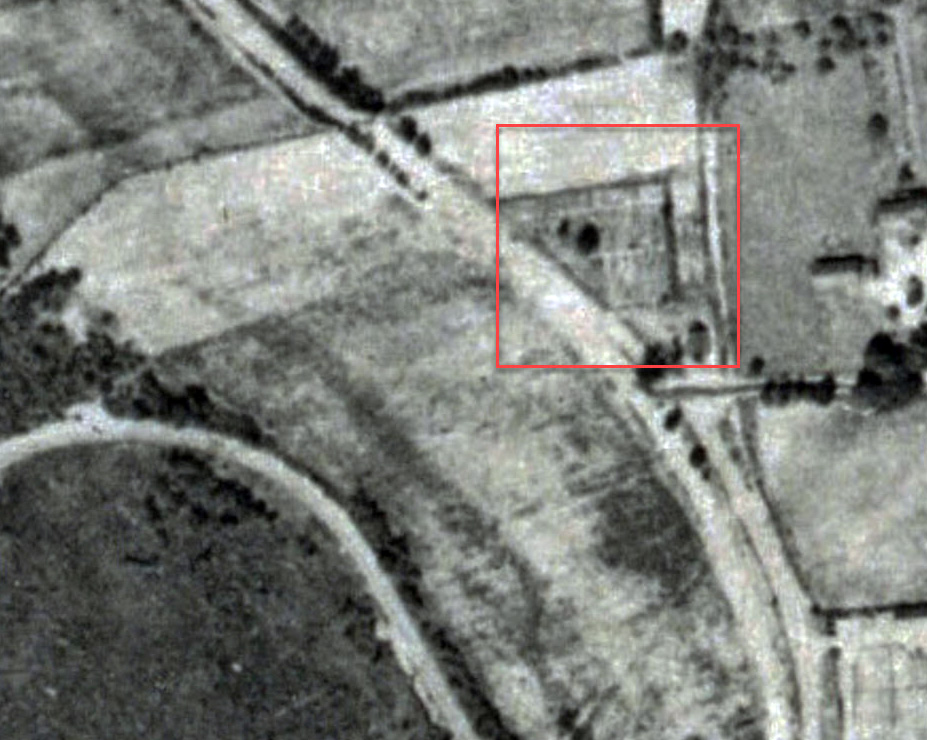
The Motor Parkway can be seen in the left corner. The Huntington Historical Cemetery is highlighted. Note: The two large trees in the cemetery.
Huntington Historical Cemetery
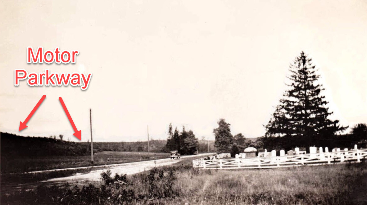
A rare view of the Motor Parkway: Looking north to the Motor Parkway (left) and the Huntington Historical Cemetery (right).
Note: The large tree matches the tree in the Mystery Foto.


Comments
Ok looks like we are facing east from the sandpit toward the Huntington Historic Cemetery and Church along Walt Whitman Rd. The parkway would run south and cross Rt 110 (where there was the toll lodge for Huntington) and head east into Suffolk Co.
In Melville of course, not to be confused with the Huntington Historic Cemetery on 25 A
LIMP heading somewhat southeast (left to right) heading for Broad Hollow Rd. The Huntington Historical Cemetery and Church can be seen north of the parkway, as the picture faces north. The bridge over Broad Hollow Rd, and the Huntington Lodge are close by.
This is not so much knowledge as logical guess work but I’d hazard that that’s looking north in Melville at the 1810 Little White Church in the Wildwood (today’s Lower Melville M. E. Church-cum-Shalom Center) at the corner of Walt Whitman Road and 110, with the LIMP in the foreground and Duryea Road beyond. The Huntington toll booth was on the west side of Broad Hollow Road (110) until 1922, when a small lodge was put up. Further, from the pristine condition of the Parkway, I’d guess ca. 1920. Sam, III
Looking west at the Bethpage Stymus farm. LIMP with guard rails left to right across bottom.
Nibbe/Stymus cemetery in center.
Halfway between Massapequa and Round Swamp Lodges.
Plainview Road left to right under cemetery.
Don’t think this is correct but it’s my only guess: looking east with the LIMP running north-south in the Melville area and the northern tip of Pinelawn Cemetery in the middle of the photo. Could be Pinelawn Road visible with the Huntington Lodge being the closest to this section.
Bethpage/Central Park
Bethpage Lodge
Stymus Nibbe Cemetary
This one has had me stumped all weekend, but here’s my best guess…
Looking East from the LIMP curve just after the Clody/sandpits bridge and about 1500 feet before the Huntington lodge. In the photo is the church and graveyard that still stand where Walt Whitman Rd and Broadhollow Rd meet.
It looks like a farm and a cemetery on the left.Location: Somewhere in Nassau county. Thanks Howard for posting. Gene
I found this intimidating, let’s see the outcome.
*Location: Photographer would be within the property of today’s Melville Sand Pits. Looks to be area where the parkway was heading west after crossing over Broad Hollow Rd, then curving NNW until west. He or she was positioned south of the curve.
*Nearest Toll Lodge: Huntington Toll Lodge.
*Roads: LIMP, Old Walt Whitman Rd., Broad Hollow Rd. Baylis Rd. in the distance?
*Historic Landmark: Lower Melville Cemetery. Burials dating from the 1800’s thru the 1930’s.
Here’s some maps:
LIMP section - Melville/Huntington, Clody Farm bridge to Broad Hollow Rd.
looking northeast towards Dix’s Hills
Closest Lodge - Huntington, Broad Hollow Rd (Rt. 110)
Other Roads - Walt Whitman Rd, Broad Hollow Rd, Duryea Rd
Historic Landmark - The little White Church in the Wildwood and cemetery
Never seen this one before. Terrain looks like Bethpage but it doesn’t resemble the Stymus’ farm(house). Motor Parkway in foreground with concrete posts at bottom left corner, and guardrails beginning at center (parkway bridge?). Too many tombstones to be Nibbe’s cemetery. It’s a long shot but I’m going to guess Bethpage looking east towards the Old Plainview Road (Pre 1908) roadway, still intersecting with a walk path that once existed before the Motor Pkwy was built. Hats off to anyone that can solve this.
A correction to my previous comment - Roads seen: LIMP, Broad Hollow Rd ( which followed the route of today’s Old Walt Whitman Rd here ), Trolley Line ( wood poles for the trolley wire seen along that row ), then possibly Baylis Rd in the distance.
First time to see any photo of the parkway at this particular location, and that it traveled along a plateau by the sand pits. The closest photos I’ve seen was at Clody bridge just to the west, and the Broad Hollow bridge to the east. Always learning something new here. Super Fantastic to the eagle-eyed experts!
Nice photo. Congrats to all who got the correct answer. I definitely didn’t give this one enough thought. Used to work in the area and went past it quite a number of times - should have came up with the correct answer!
Trying to locate where the photographer was standing. In the mystery photo the white church is in the distance and away from the cemetery. The cemetery today is still located in the backyard of the white church. Both were slightly moved to the west after 1947 to make room for Broad Hollow Rd expansion. The trolley line followed today’s Broad Hollow Rd, just behind the cemetery in the distance. The ‘38 and ‘47 aerials both show no roadways or cemetery in this sand pit region of Melville, but farmlands. Where was the photographer standing?
I lucked out when coming across one of Howard’s panoramic views of Melville circa 1930.
Like Sam III figures, the image is 1920 or earlier. Looking closely, I see wood/cedar posts on either side of the parkway. Then there’s the trolley line that continued straight from Duryea Rd then north until it met up with Broad Hollow Rd again. This stretch of the trolley row eventually became the section of Rte 110 we know today.
Wow; I was about to comment that this is nowhere near the sand pits when I had the sense to look first. WOW! I’ve been in and out of the area most of my adult life, worked nearby for 17 years, and LIMPed around there for some 20 or so and never realized. See, I’m NOT too old to learn. For those of you who also were unaware, see the attached aerial view. Sam, III
Ugh! I’m not convinced, there’s too many conflicts. Maybe I’m missing something. Can someone please point out where the white church is in the mystery photo? All I’ve got is we’re west of the Huntington Lodge. The orientation could be incorrect as well. Still working on this….
Hmm. Frank might be right but I think not; I spotted it instantly as the Wildwood church burial ground. I was wrong about direction - east, not north, and Broad Hollow, not Duryea, but I now think that the church is just out of the picture to the immediate right. The photographer is on the west end of the LIMP curve. Does anyone know how far the church and graveyard were moved? Sam, III
Frank - I just now spotted the church, to the right of the yellow dot on both closeups below. You’ll also see the orange dot next to the dark building, which I figure was for preparation of the deceased, burials etc. The buildings that are just east of the trolley tracks seen here are evident on the older aerials. Trolley line was quite close to the church, definitely imagine a on & off stop here.
Thanks Brian. I was focusing on that white building in the back with its steeple as the church. It wouldn’t make sense that far away, and its configuration in the photo doesn’t match today’s church. This is one tricky photo. Thanks!