Mystery Foto #37 Solved: Motor Parkway Remnants at Half Hollow Road, Dix Hills in 2008
My Favorite co-author Al Velocci challenged you to solve this weekend's Mystery Foto.
Mystery Foto questions:
- Identify the location of the Mystery Foto and orientation of photographer Al Velocci
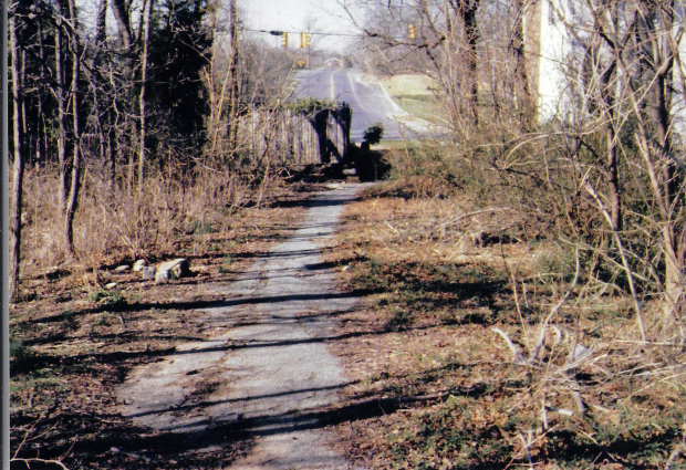
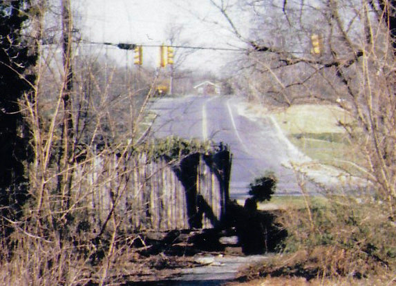
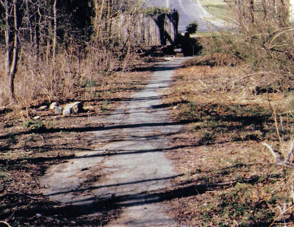
Al Velocci: The Motor Parkway south of Half Hollow Road at Half Hollow Hills (Dix Hills). The view is looking to the north toward the western terminus of the Motor Parkway.
This section of the parkway is now Route 67 and called the Vanderbilt Parkway.
- Kudos question: What Long Island Motor Parkway Preservation Society event happened within five miles of this location?
Two events qualify for as the correct answer:
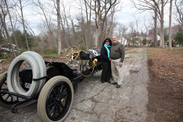
In April 2012, the Long Island Motor Parkway Preservation Society viewed a 275-foot section of the parkway in their nearby Dix Hills backyard. Newsday did a cover article on the adventure "Motor Parkway: The Road to Yesterday".
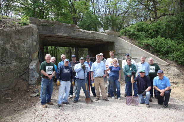
The Long Island Motor Parkway Preservation Society helped clean up the Old Bethpage Motor Parkway Bridge from 2011to 2012.
Comments (10)
Very impressive that nine LIMPERs correctly identity the Mystery Foto!
Congrats to Ron Ridolph, Ernie, Greg O., Frank Femenias, Sam Berliner III, Steve Lucas, Chris Lindsley, Brian McCarthy and John Cunningham to correctly identify the Dix Hills section of the Motor Parkway.
Kudos to Ron Ridolph, Greg O., Steve Lucas, and Brian McCarthy for identifying two nearby Long Island Motor Parkway Preservation Society events in the good old non-pandemic days!
Enjoy,
Howard Kroplick
Close-Ups

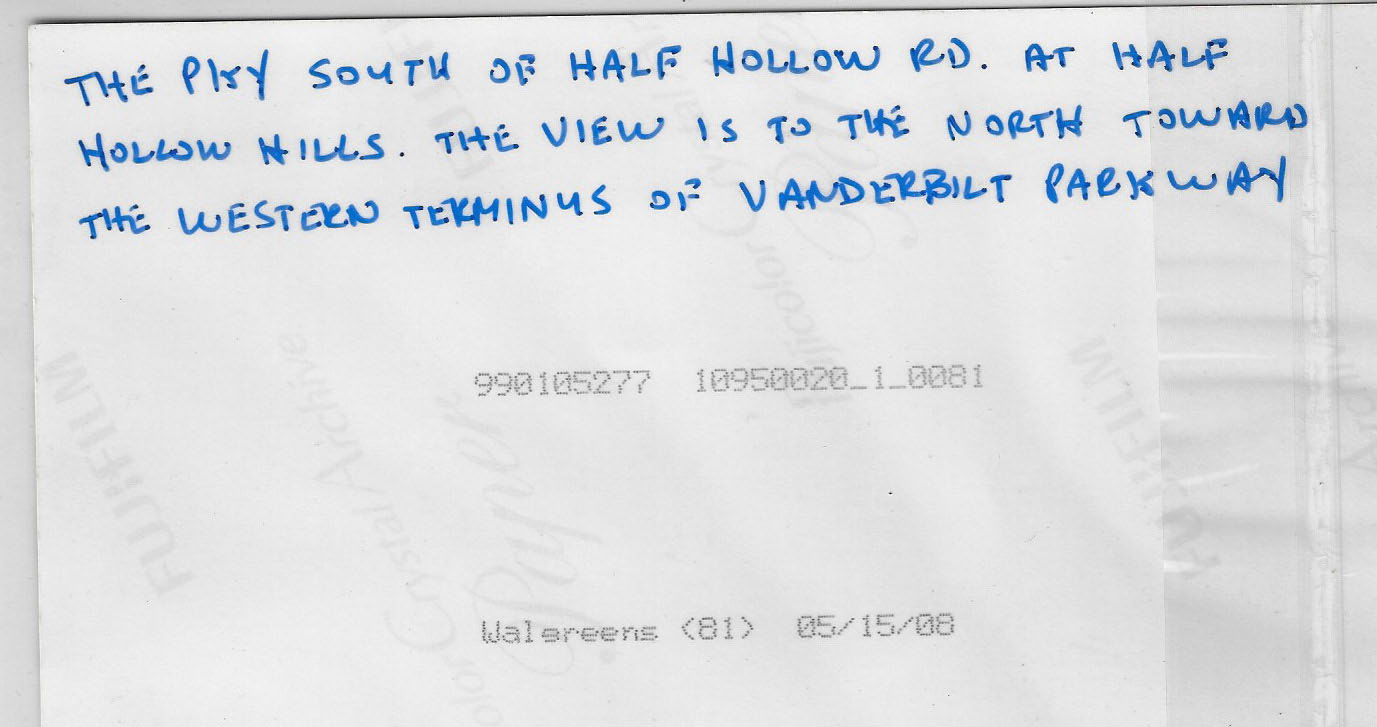
Al Velocci's caption on the reverse side of the photo dated May 15, 2008.
Long Island Motor Parkway Preservation Society Events
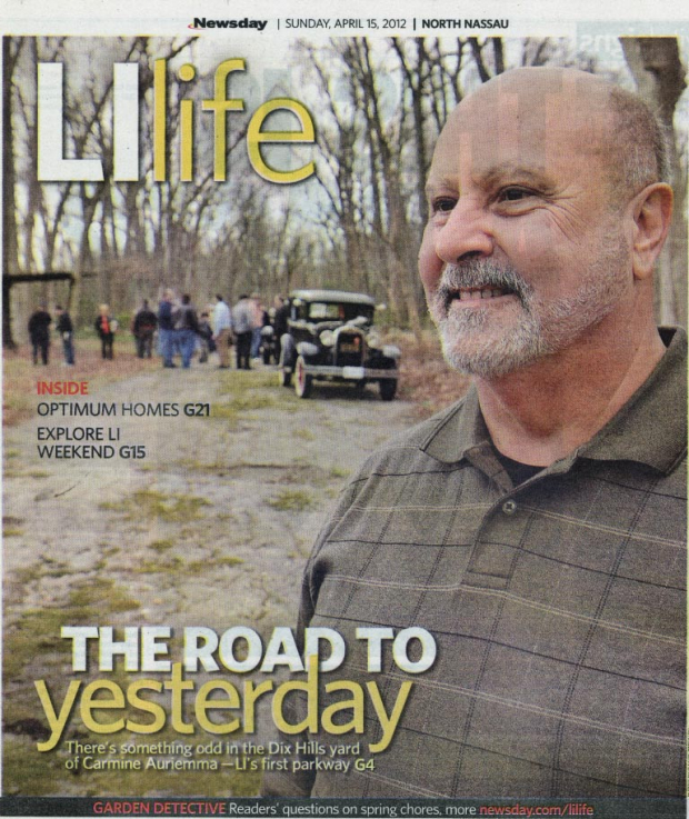
Long Island Motor Parkway Preservation Society Visits a Hidden Parkway Section in Dix Hills


Comments
LIMP Mystery Photo of 9/11/2020:
1./ You are on the original LIMP in Dix Hills, NY and looking Northeasterly as it
becomes CR 67 as it meets and crosses over at Half Hollow Road east of Fox Lane.
2,/ In fall of 2012 and in the rear of 19 Broad Oak Lane, Dix Hills, at the home of
Carmine & Arleen AURIEMMA, the LIMP Preservation Society visited and discovered
a portion of the LIMP under years of grown brush in their backyard and this later
was a feature story in Newsday. My Best To All and Cheers !!! Ron Ridolph
While I pride myself on knowing the LIMP (I live half a block from it in Levittown and played on it as a kid) I have to admit I am stumped on this. I even used the Google Maps online map of the LIMP and could only come up with one similar scene where the LIMP crosses a street with a traffic signal.
That would be the current west end of Vanderbilt Pkwy at 448 Half Hollow Road in Dix Hills. While the traffic light plus existing roadway matches I cannot see the split rail fence nor any of the original remaining roadway.
Looks like Al was maybe looking northeast down the LIMP at the beginning of the paved section of Vanderbilt Parkway (67) and Half Hollow Rd in Dix Hills.
Back in March 2012, about 40 of us LIMPPS members met up behind a home on Broadoak Lane in Dix Hills where the owners shared their maintained section of the parkway in their backyard with us. It was a great day!
https://www.vanderbiltcupraces.com/blog/article/long_island_motor_parkway_preservation_society_visits_a_hidden_section_of_t
Not sure - too many conflicts. Best guess is LIMP looking north at Rt. 67 (also LIMP) in Dix Hills, where it intersects Half Hollow Rd. Photo taken on a winter’s afternoon. Tricky photo, thanks Al. Looking forward to this week’s answers.
Here goes nothing! It’s gotta be on the LIMP RoW, looking north, over the fence, across Half Hollow Road, up the south-western end of (so-called) Vanderbilt Parkway, Suffolk County Road 67, in Dix hills. That’s bracketed by No. State and the Expressway (I-495) and by Old East Neck Road and Deer Park Avenue (231). So far, I haven’t found my old pix of the spot looking south but here’s the view north-northwest on 01 Apr 2000 (from my Page 7). Al was looking towards the Half Hollow Hills Library, where you (HK) gave a LIMP presentation and book signing on 30 Nov 2016 (see 29 Nov 2016 blog). Sam, III
I believe Al took this photo from the south side of Half Hollow Road looking north across the road to the beginning of the current Vanderbilt Parkway. A few years ago there was a LIMPPS event in the backyard of a homeowner on Broad Oak Lane, a few blocks south of this photo. His name escapes me but he allowed several LIMPPS members to enter his yard and drive on the LIMP remnant.
This is in Dix Hill, where the existing ROW begins. Al is taking the picture just south of Half Hollow Hills Road
I think Al shot this image from the side yard of a home located on the west side of Half Hollow Rd, Dix Hills. Viewing east, he captured the LIMP remains and the intersection of Half Hollow Rd & Vanderbilt Pkwy. Must have been late winter/early spring. The house seen in the distant east is likely on the north side of Vanderbilt Pkwy, pkwy curves to the right a bit there.The spruce trees situated on the right side of the pkwy presently aren’t seen in Al’s photo, must have planted sometime between then and now.
Significant event within 5 miles is likely the cleanup of the Old Bethpage Pkwy Bridge in 2011 & 2012.
Just a guess… Where the current vanderbilt parkway picks up at half hollow road
Near the old courthouse road bridge?
Sam - I believe I speak for all here, FIND THAT SOUTHBOUND PHOTO! Lost views of the parkway are precious and high in demand now.
Myself having difficulty with this mystery photo, amazing how many actually solved it! The LIMPPS don’t mess around.
Hey, I should be miffed; my library event is certainly as good as any (and i even documented it)! Frank, I’m a’workin’ on it. Sam, III
Howard, Not generally known is that Suffolk County’s original choice for the western terminus of the Motor Parkway was to be at Deep Park Ave. Many taxpayers in the western part of the County grumbled about about it and wanted the western terminus at Rte. 110. A compromise was reached and settled on Half Hollow Rd., the County explaining that there were sufficient roads west of that location.
@Frank Femenias: Do you have the Online Google Map of the LI Motor Parkway, right?
See Featured links on the Home Page https://www.vanderbiltcupraces.com/
I noticed a home on Fox La, near Melissa Dr utilized the LIMP on a 1966 aerial. There was deadends at each side of Fox La then. They had a neat route to Vanderbilt Pkwy until the area became more developed. Believe this is the same home to the present, with additions.
Howard Kroplick:
The link to the Interaction Long Island Motor Parkway map can be found on the “Featured Links” on the Home Page.
Thanks Sam III for the heads up!
Great aerials Brian. The 1966 shows the old roadway still intact, and for a good length! Great stuff!
Great information