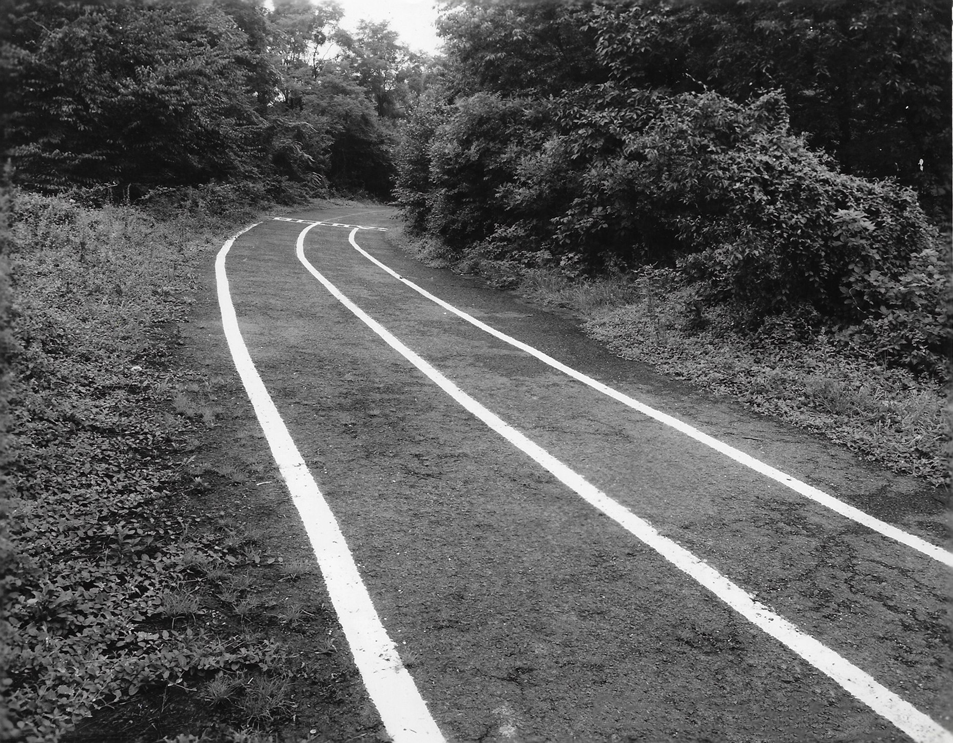
Mystery Foto #41 Solved: A 1938 View of the Queens Motor Parkway Bike Path Looking West from Bell Boulevard

Did you identify this weekend's Mystery Foto?
Answers to the Mystery Foto questions:
- Identify the location of the Foto and the orientation of the photographer. Provide a rationale.
Motor Parkway looking west from Bell Boulevard in Queens. Rationale: The bike path striping and the curve to the right.
- What was the use of the road in the Foto?
Bike path now the Brooklyn-Queens Bike Path.
- What was the date of the Foto? Provide a rationale.
August 4, 1938. Rationale: The new striping.
Comments (10)
This Mystery Foto was a toughie! Congrats to Sam Berliner III, Brian McCarthy, Al Velocci and Greg O. for identifying the Queens location.
Kudos to me for stumping everyone!
Enjoy,
Howard Kroplick
Close-Ups

Caption: Motor PWY. W. from Bell Blvd.
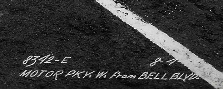
Although, the year fades into the white stripe, the date appears to be 8-4-38. One month, earlier, New York City Parks opened the Queens Motor Parkway Bike Path.
Location of the Photographer
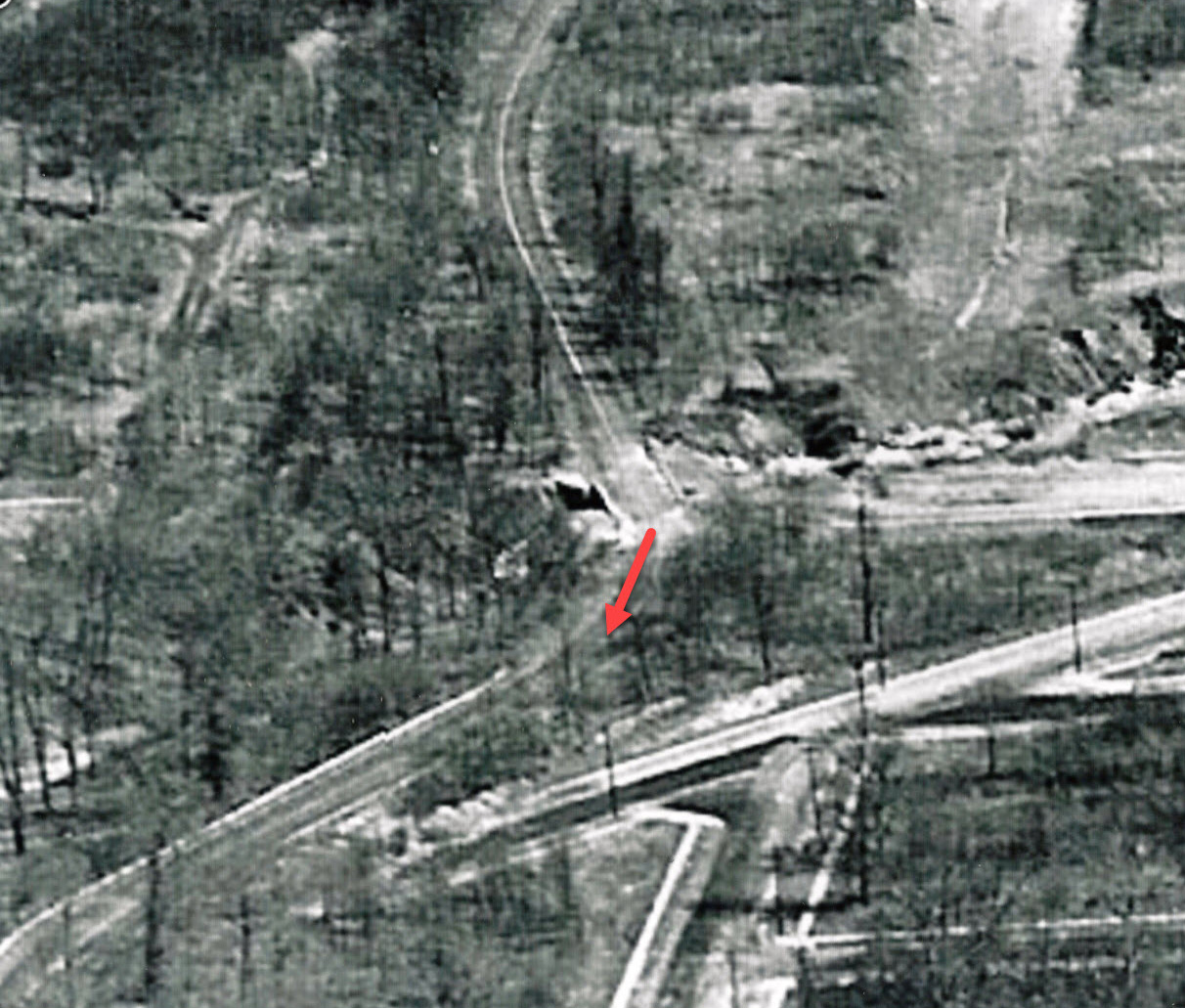
This 1941 aerial shows the likely location of the photographer near the Central R.R. Bridge which was used by the Motor Parkway.
This path was abandoned when the Bell Boulevard Bike Bridge was built. Provided by Frank Femenias
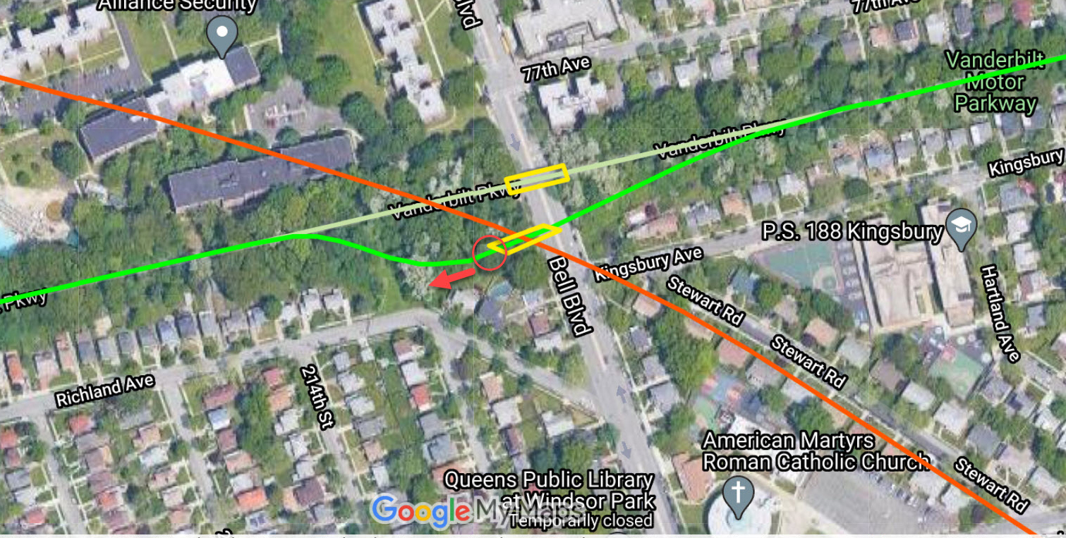
Sam & Dave explore the Central R.R. Bridge Bypass.


Comments
This mystery had me struggling. It’s not a bicycle path in Queens, it’s a car path with well defined lines, missing the yellow center line defining two-way traffic (Queens bike path had a single center white line). Exhausted, my best guess is somewhere in Suffolk on Rt 67. Orientation? Forgetaboutit, there’s no shadow to determine anything. Very difficult. Super High-Five who guesses this. I’ll be back for closer examination
Top photo: Cyclists struggling the 8% grade under GCP in Queens, 1940.
Great Motor Parkway Foto Howard!
This is during early Motor Pkwy closure on Rt 67, about 1943. Looking forward to this week’s answers
Not much to go on - but here’s two gueses:
1) Great Neck schools property before turning right over the Northern State
2) Bethpage State Park
Bethpage Bicycle Path. East side of the Bethpage State Park in 2013 they extended the Bicycle path.
Queens bikeway when first opened or when just repaired and restriped. ??? Sam, III
Location & Orientation - I have 3 answers. A - ( most likely ) The photographer was on the LIMP, viewing West. He or she was between Wheeler Bridge 2 & Grand Central Pkwy. B - ( likely ) On the LIMP, viewing East. Between Wheeler Bridge 1 & Grand Central Pkwy. C - ( least likely ) On the LIMP, viewing South in Bethpage State Park. Between Botto Farmway Bridge & Transmission Tower ROW. Perhaps this section was to become a bike path soon after the pkwy closing as this was done in Queens? We all know that most of this section is now part of the trail today. We all see the ‘crossway’? where the new painted lanes stop. Guess they continued to paint new lanes ahead? Was this something that was done, but not continued when fading?. I don’t recall the Queens section having these type of lanes today.
Date of Photo - roadway looks in fairly good condition. I’ll say 1955 based on images in 1940 and 1970.
More images.
Since I have not been able to locate any solid evidence of an exact location, I’m going with two wild guesses: first, looking northeast in Bethpage State Park near the polo field and used as a bridle path; second, looking east near Alley Pond Park and marked off for footraces. Due to extensive vegetation on the concrete extensions, I’ll guess the date around 1950.
I believe we are looking at part of the bicycle path that Moses created out of part of the Queens portion of the Motor Parkway.
Stumped this past weekend. Thinking it has something to do with bicycles on the Queens section.
Another super rare and amazing LIMP view Howard! I was always hoping this LIMP view by the CRR would ever be seen in photography today. You’ve managed the impossible. GREAT SHOT!
Brian and I walked this path within 5 years, but by then was a dirt path with some concrete posts still in place. It is still accessible from the current Brooklyn-Queens Greenway for all to follow.
Never thought about this original section to be the answer. They may have wanted to establish specific lanes for bikers and walkers. But maybe people didn’t stay in the lanes as intended, and then there was confusion and crashes, especially on curves. Figure the crosswalk led to Bell Blvd.
Brian, When first opened, Moses said ” it was exclusively for bicycle riders”. He further stated “facilities for cyclists are the biggest unsatisfied need facing the Parks Department today”. Sound familiar?
Sam, Your comment on Oct. 9, about the bicycle enclosure. At the beginning the Parks Dept. planned to accommodate bicyclists who preferred to leave their bikes there, They would be charged a $2.00 monthly fee for the privilege, one of the reasons for the automobile parking spaces. Don’t know if it was ever implemented.
Brian, the barely-legible crosswalk may be warning, “SLOW”. I beleive I see an “O”, and a “V (W)”. This curve was likely treacherous with its blind curves in both directions. I find it a more interesting bike-path feature than the current straight path. I’m guessing its removal was due to Bell Blvd expansion below
Remember you and I snapping images of this area Frank, but their not in my email anymore. An image from the site here below, opposite direction.
Great eastbound shot Brian! That’s the fork that has confused most of the real Motor Parkway path
I wish Mitch Kaften and Roy Warner would chime in on this mystery photo. Both were residents in the area, and would know exactly how it went.
I would like to confirm Howard’s assertion and offer some more details using digital editing techniques.
By inverting the photo and enhancing contrast, the “mystery word” is CAUTION (part of C and the N is not visible), which makes sense as bikers are about to cross a bridge.
Paying attention to the tree and tree line in the mystery photo enables one to match trees to various aerials and look for a narrowing of parkway just before a curve (traveling west).
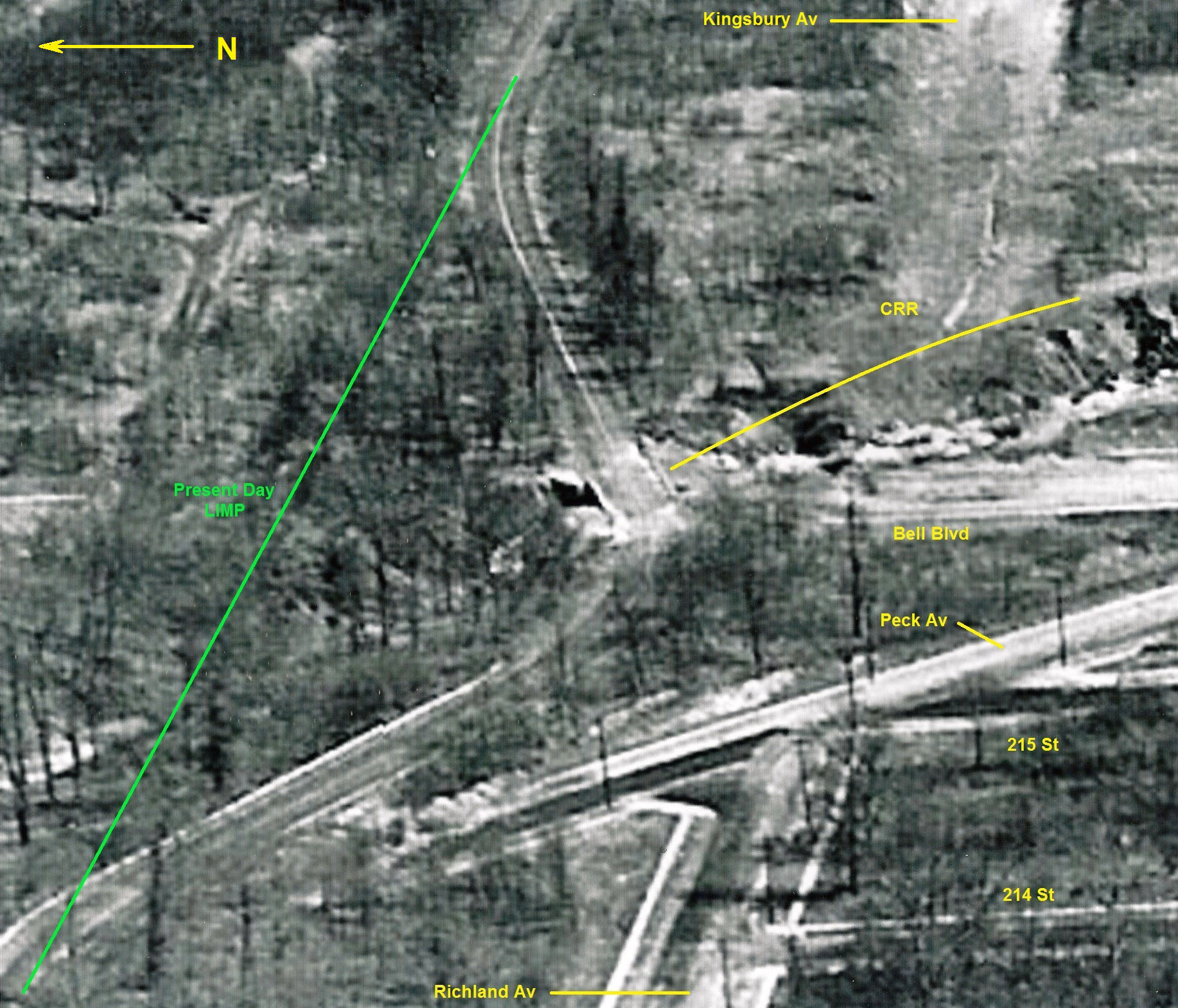
Elsewhere, Howard has a June 1938 aerial, a close date to the August 1938 date of photo. I have both warped and inverted that aerial and labeled the “circled trees,” the only stand of trees that match the upper left tree line in the mystery photo. (The top picture has EAST on the top, the bottom has WEST on the top.) Note that Peck Ave is being constructed, although part will be demapped by 1951. The Xs are the photographer position and the horizontal slash over which Peck Ave crosses is Bell Blvd.
The 1951 NYC aerial makes the relationships easier to see, even though the trees in the upper right of the mystery photo no longer exists. By 1951, the demapped Peck Ave is being erased and the Central RR ROW from Kingsbury SE is being filled in to form Steward Road. Although a bit grainy in the photo posted, there is clearly a tree on the curve overhanging the parkway.
Also note the location of the continuation of the Central RR ROW. I conclude that the original bridge was partly “over” the future Bell Blvd., not slightly west as drawn in an illustration above. (Topographic Bureau maps circa 1950 support my conclusion.)
As a child I always imagined that what Brian shows in his picture was the Central RR roadbed because it crossed the LIMP and continued on the other side. If you measure distances to the new bridge and various angles you will discover that one is mostly looking at the remains of the demapped Peck Ave. on both sides of the LIMP.
In the 1951 aerial, you can see how Peck and the original LIMP path merged and what I know realize is the LIMP path I though years ago was a trail blazed for convenience. So somewhere on Brian’s fork one could see the original LIMP path weakly, but on my last visit over one year ago, foliage obscured that.
Finally, for those not familiar with this area I wanted to show how Peck Ave abruptly ends in the area. That’s an easy way into the LIMP, if you don’t mind walking through underbrush. Amazingly, I discovered a tree that is the right age and species to one of the trees in the 1938 photo! I sspect this tree is the tree above the S in the label CIRCLED TREES, which forms part of the upper right tree line in the original mystery photo.
Excellent observation David. I failed to acknowledge that the CAUTION warning could work on the ascent towards the bridge as well. Nice work.
The CRR through this intersection curved towards the west. In the ‘51 aerial below the RoW can still be seen on the north side of the LIMP, placing the bridge slightly more west. The ‘24 aerial shows the broad curve.
Thank you Frank for pointing out the curve, and yes, my blue box should have more overlapped my Steward Road label. I think the 1949 Topographical (not Topographic as I wrote) Bureau from 1949 clearly shows the Central ROW across the former LIMP and Bell Blvd.
CREEDMOOR (Parkway) is defined by black dashed lines. The red lines define the future Stewart Rd. The Central RR ROW is the dot-and-dashed lines, the northern side of which has been highlighted by a green pencil. There is a slight bend in the green pencil line as it meets the former LIMP ROW (also highlighted in green), but the southern side has no bend. In any case, the original overpass must have fallen inside this ROW, thereby crossing the modern Bell Blvd. Note the (proposed) replacement overpass on this map.
Fred, I suspect the line you noted in the 1951 aerial is the southern edge of the ROW, if the line is related to the ROW. Taking a second look at the aerial, I notice a parallel construction path to the north that is separated by that line by a grove of trees. The two lines together likely define the ROW.
I have also posted a Wigmore Land Company map that shows the the ROW. The trace of the northern edge of Peck Ave bends inside the LIMP, at a point clearly north of the Bell crossing. This map shows how Hillside Park became part of Cunningham Park and a part of Busby Ave, shown on the infamous 1922 Hagstrom’s map, that was built. (Busby Ave can be seen about to be erased in the 1951 aerial picture.)
The 1909 Bromley Queens map shows an unequal widening of the ROW in the area that Fred circled. The north side of that widening is consistent to the northern edge green pencil bend in the 1949 survey map that makes the ROW edges non-parallel at that point. The unequal widening makes it hard to tell visually exactly where the finish of the railroad curve was.
Thanks to Fred, I have discovered NYCityMap segment 11c is presented incorrectly, shifted to the SW relative to the street map on the site. If uncorrected, that shift would make it seem that original bridge was not over Bell.
As a final(?) word, look at Howard’s bridge series #4 post dated 11 Aug 2011. The abutment seen matches well to detail that can be seen in segment 11c in the area that Fred circled, if viewed at maximum magnification. The first photo in “2011 Current Views” of that post shows remains of Peck Ave pavement on both sides of the path as well as the original LIMP angling off, as I tried to describe in my earlier post. Howard and Al found TWO things when they explored that area in July 2011!
David, I see your point. The 1949 Topo also places Creedmoor Pkwy (Stewart Rd) directly in the center of the former CRR RoW, while Kingsbury Av today did get its slight bend northward as indicated.
The Topo however is missing key elements to help determine exact location of the original bridge, but allows estimation of its placement. I’m getting the bridge slightly to the east of Bell Blvd center, and the Wigmore map even more to the east.
I zoomed out of the 1951 aerial (photo below).
The CRR’s north and south RoW boundaries can be seen in white (Peck Av to the south, Underhill Av to the north). In various sections in Queens, Peck and Underhill follow the RoW. The line I had indicated earlier likely the center of RoW that had not yet been filled by overgrowth.
The inaccurate tiling of online aerial photography, including NYC’s 1924 11C, has been an issue and need compensation for more accuracy when overlaying maps. I only use aerial photography and find their results more accurate than using maps.
Frank, David - All this talk about the bridge sent me back to a past mystery foto. As much as I liked the photo, it was taken up so close that it was difficult to see beneath the bridge. Dated 1944, so likely prior to the building of the straight bike path & bridge over Bell Blvd today?? Do the below marked images look right to you?? Kudos on making out CAUTION on the bike path, David.
Brian, photo B I believe is in opposite direction of photo A. According to the caption, photo B is with north up. Love these pics, the only photos of the bridge so far. I found more photos of the dirt CRR RoW underneath. Will post them later…..
Top photo - CRR looking south from LIMP, 31Oct1928
Mid photo - CRR looking south at 75 Av’s stone wall barrier, 31Oct1928
Bottom photo - CRR looking north from Hollis Ct Blvd, 31Oct1928
Brian, in photo B above the CRR bridge was missing some railings and hazardous to cross by bike.
In David’s 1949 topo the CRR is indicated in pencil as “deeded”.
I’m guessing the plan to clean up this area and to construct the new overpass over Bell Blvd included the City’s purchase of this CRR segment, and wasn’t completed until the early ‘50s. Any thoughts folks?
I see it now, Frank. My B image is viewing TO THE NORTH. There’s also the tree right next to the east abutment in the A image. The tree is on the opposite side of the bridge in B image. Now I need to flip my brain around : )
David’s 1949 topo map (below) reveals the original bridge already removed (1944+), and shows space for a future straight bridge (just to the north) that will eventually be installed over Bell Blvd, to continue the bike path. It’s possible the bikeway in this construction site, was closed for up to 6 years to complete the modifications. I don’t believe the construction took that long, not in NYC. Any input is welcomed here.