Mystery Foto #44 Solved: Curtiss JN Jenny in the clouds over Curtiss Field in 1925

Historian Bill Bellmer challenged you to solve this Mystery Aerial.
Answers to the Mystery Foto questions:
Identify:
- The location of the aerial and orientation of the photographer
Looking west over Curtiss Field (later Roosevelt Field)
- Identify the major roads
From left to right (south to north):
Commercial Boulevard, Stewart Avenue, Long Island Motor Parkway and Old Country Road (far right)
From bottom to top (east to west)
Clinton Road, Long Island Motor Parkway, Washington Avenue.
- Long Island Motor Parkway structures
Old Country Road Bridge, Mayan Ruins, Clinton Road Bridge, General Manager's office, Garden City Loadge
- The date of the aerial. Provide a rationale.
July 9, 1925. Rationale: Mott section not built, airplane markings, no golf course.
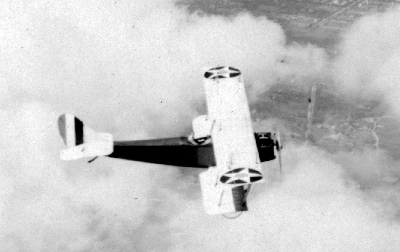
Kudos question: Identify the airplane.
Curtiss JN Jenny (either JN-4 or JN-6)
Comments (7)
Congrats to George Phillippides, Steve Lucas, Art Kleiner and Frank Femenias for correctly identifying the Mystery Aerial location over Curtiss Field.
Kudos to Steve Lucas, Art Kleiner and Dick Gorman for identifying the JN in the clouds as a Curtiss JN Jenny.
Enjoy,
Howard Kroplick
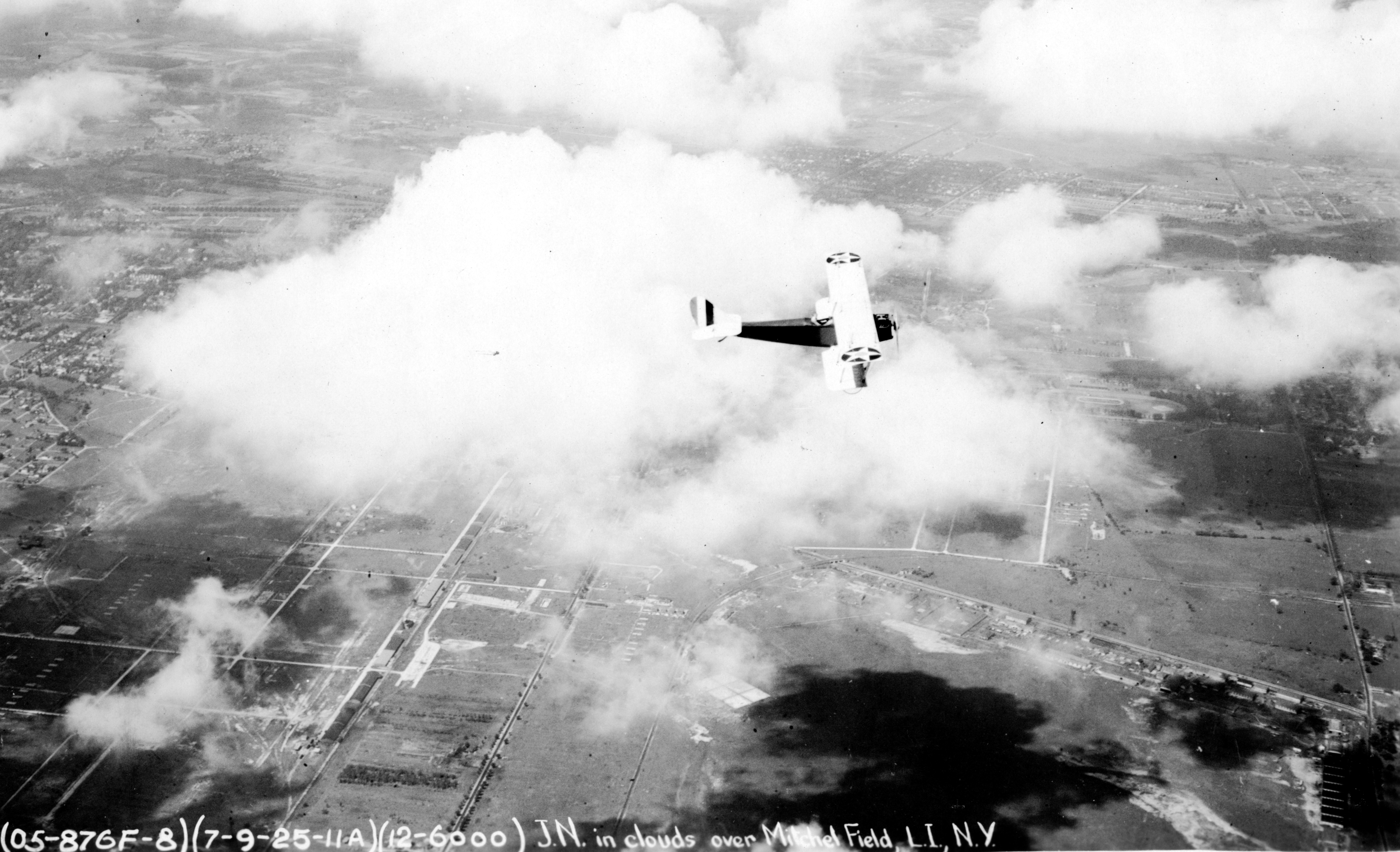
Caption: 7-9-25 11A J.N. in clouds over Mitchel Field ,LI,NY
Correct caption: The airplane is over Curtiss Filed on July , 9, 1925
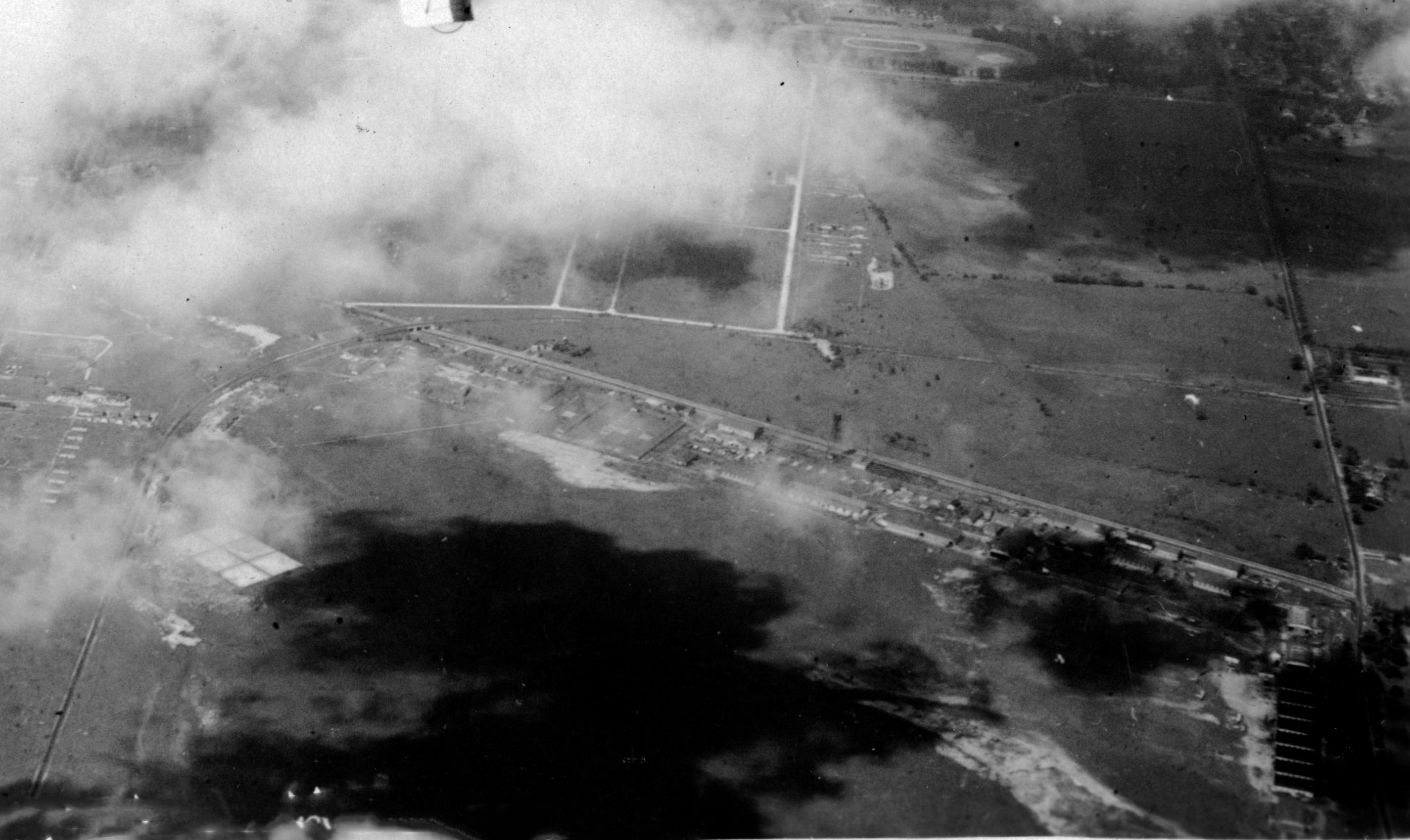
Close-Ups


Comments
That looks like the LIMP curve in Garden City, which would mean that the photographer is looking west and the plane is traveling due north. I see the Clinton Road and Old Country Road LIMP bridges. The photo has “J.N.” in the caption, so is the plane a Curtiss Jenny?
-The location of the aerial and orientation of the photographer
Photographer is looking West directly over Roosevelt Field.
-Identify the major roads
Old Country Rd vertically on the extreme right. Clinton comes in from the right with the curve of the LIMP over Clinton towards the middle in the lower part of the photo. Stewart vertical on the left.
-Long Island Motor Parkway structures
Old Country Rd bridge, Mayan ruins, Clinton bridge, managers office, Garden City lodge.
-The date of the aerial. Provide a rationale.
Kudos question: Identify the airplane.
The Curtiss JN Jenny was introduced in 1915 and used through the late 20’s. I’ll go with the guesstimate of about 1920 for this photo.
Location: Over East Garden City/Roosevelt Field looking west
Roads: On left, Stewart Avenue, Long Island Motor Parkway which crosses Clinton Rd and Old Country Road. Washington Avenue on top near Mineola Fairgrounds
LIMP structures: Clinton Rd bridge, Mayan Ruins,Old Country Road bridge
Date: Pre 1951 since Mineola Fairgrounds visible. Likely 1920s given lack of roads/houses in northeast GC and Mott section
We are looking west over East Garden City over today’s Roosevelt Field shopping mall. Major roads include the LIMP, Clinton Road, Old Country Road, Stewart Avenue and Commercial Avenue. LIMP structures include bridges over Clinton Road and under Old Country Road; also the Garden City Lodge and superintendent’s office. I think the plane is a Curtiss JN-6 “Jenny”. Based on what appear to be then current US Army Air Corps markings on the plane, I’ll date the photo around 1922.
Garden City, looking west.
Old Country Road, Clinton Road, LI Motor Parkway, Stewart Avenue.
Clinton Road Bridge, Old Country Road Highway Bridge, Garden City Lodge, Superintendent’s first office.
approx. 1918. No homes built. Intercollegiate Golf Club not built yet.
Curtiss Jenny (possibly the “H” model being tested as there seems to be an “H” on the nose and there is no ID number that I can see. The “H” model came out in 1918. (To be honest I saw Curtiss Jenny noted on a comment that was opened, but not the H).
Happy Halloween!
Mystery Foto #44… Can’t answer the aerial questions but the plane is a US Army Curtiss Jenny JN 4.
Over Roosevelt Airfield looking west (I can see Lindbergh’s hangar 16). Old Country Rd at extreme right, Clinton Rd running diagonal across the bottom of photo, From the left: Camp Mills Base Hopital’s East Main St/East New York St (Chestnut St)/East Commercial Av (Commercial Av)/CRR/Stewart Av. Cannot see LIMP structures but….. present in the photo is the Old Country Rd highway bridge underpass, Mayan Ruins proposed bridge, Clinton Rd parkway bridge, Superintendent’s house at 1 Vanderbilt Ct, and Garden City lodge - moved in 1989 to 7th St and now serves as the Garden City Chamber of Commerce, Camp Mills Base hospital roadways, west of Clinton Rd, also appear clear and still in use. The structures however appear removed; the clouds make viewing challenging. Photo’s date close to 1920(s) with Camp Mills Base hospital possibly removed.
Thank you Bill Bellmer for the challenging photo!