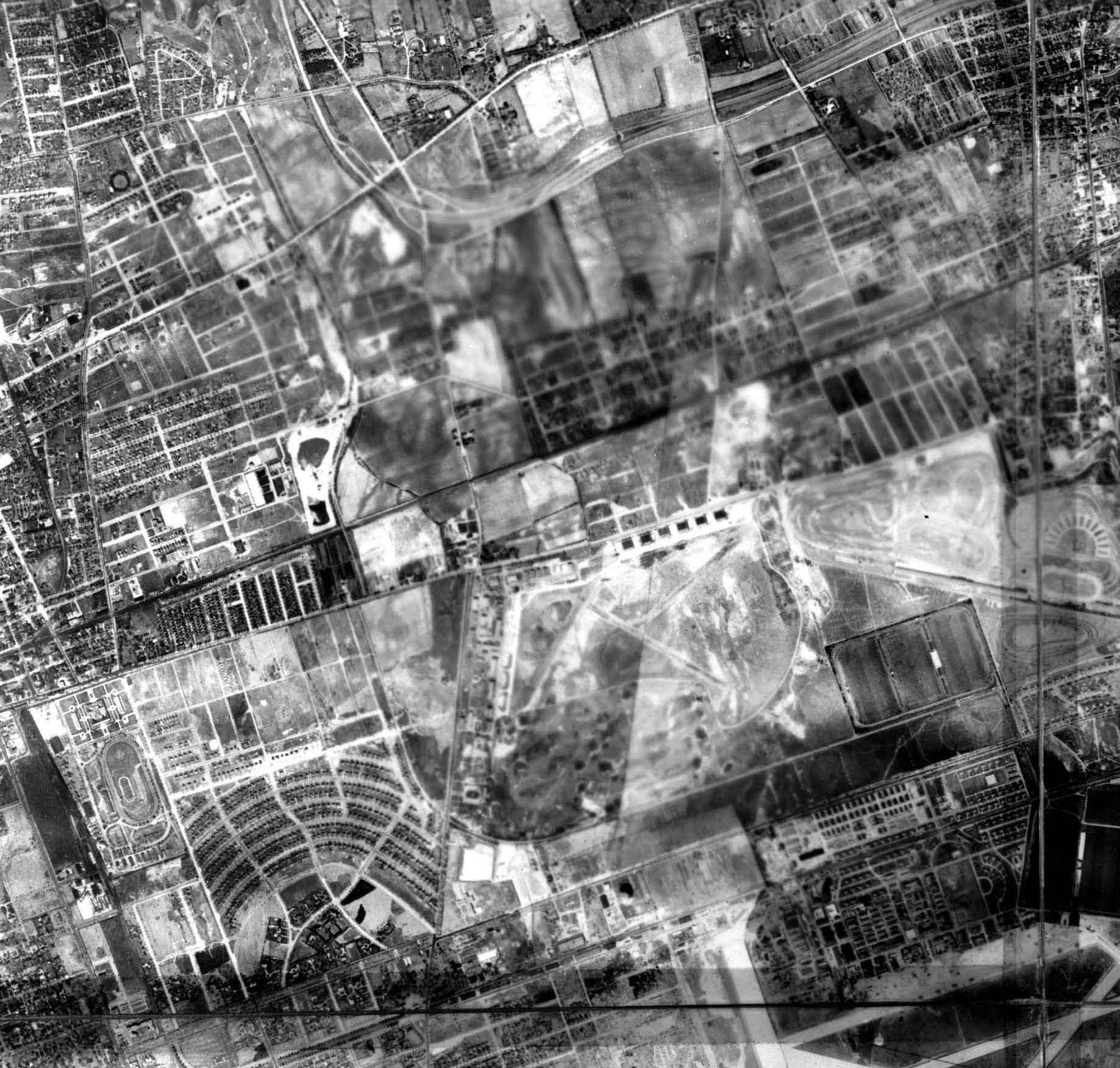
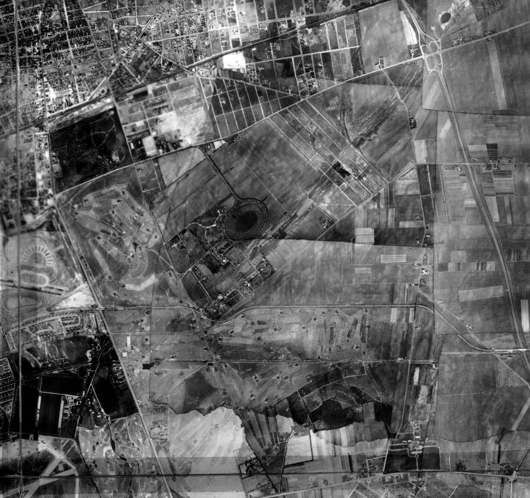
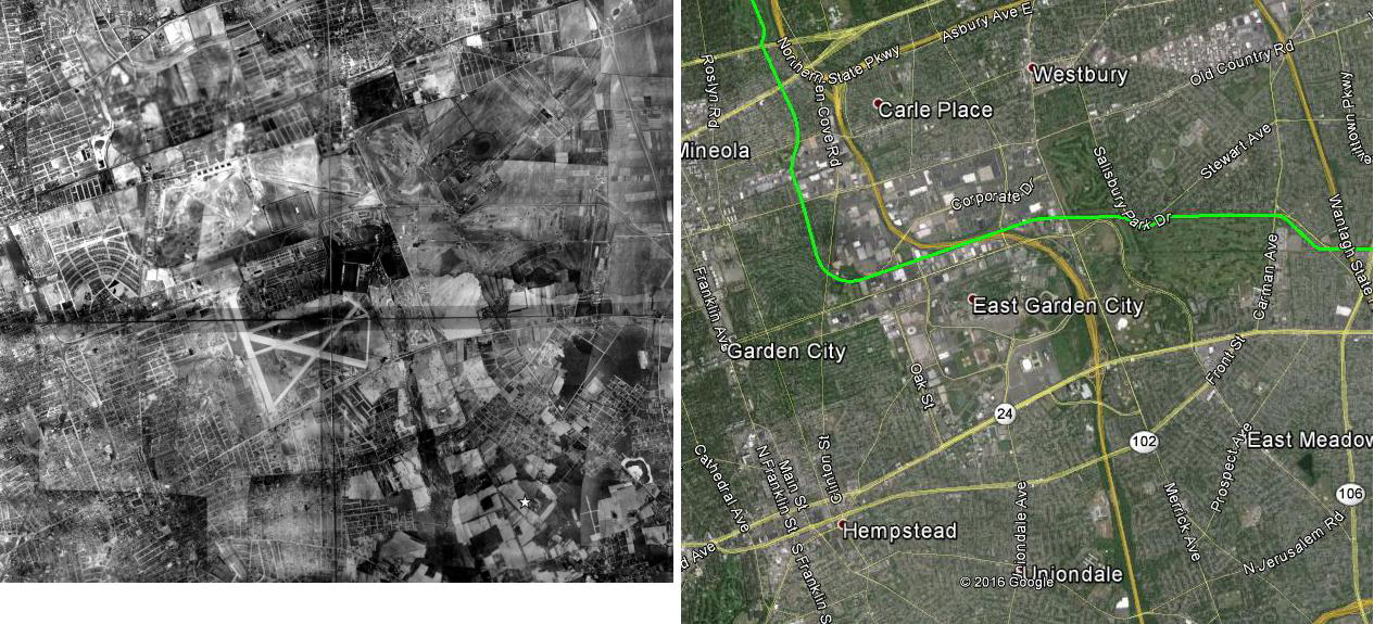
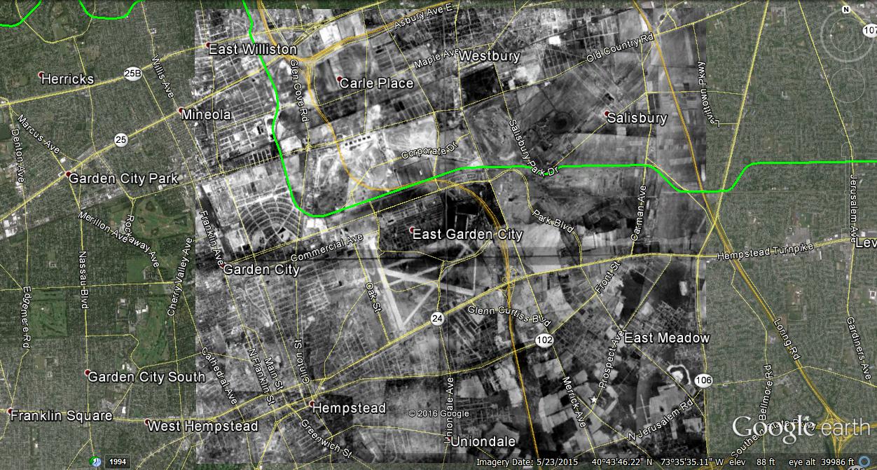
Mystery Foto #4 Solved: A 1942 Composite Aerial of Mitchel Field and Roosevelt Field-Updated 1/26/16
As requested by popular demand, here was the first Mystery Aerial of 2016.
Mystery Foto questions:
- Identify the villages in the aerial (See below Femenias' Findings)
- East Williston, Mineola, Carle Place, East Garden City
-Hempstead, Uniondale
-Westbury, Salisbury
-East Meadow, Levittown
- What is the approximate year of the aerial? Provide a rationale.
April 24, 1942
Clues: The runways of Mitchel Field, Roosevelt Raceway, the missing Motor Parkway bridges, the Garden City housing developments and Meadowbrook Hospital.
- Identify the Long Island Motor Parkway landmarks
Remnants of the Motor Parkway and its bridges from East Williston to Levittown. Still standing but not really visible: Garden City Lodge and the General Manager's Office in Garden City.
- Identify the golf course and sports venues
Wheatley Hills Golf Club,Old Westbury Golf Club, Meadow Brook Golf Club, Salisbury Golf Club and Coldstream Golf Club
Roosevelt Raceway and Meadow Brook Polo Club field.
- Identify any other Long Island landmarks
Mineola Fair Grounds, the estate of Emily Ladenburg, Meadowbrook Hospital (now Nassau University Medical Center) and Hempstead Turnpike, part of the course for the 1904 Vanderbilt Cup Race.
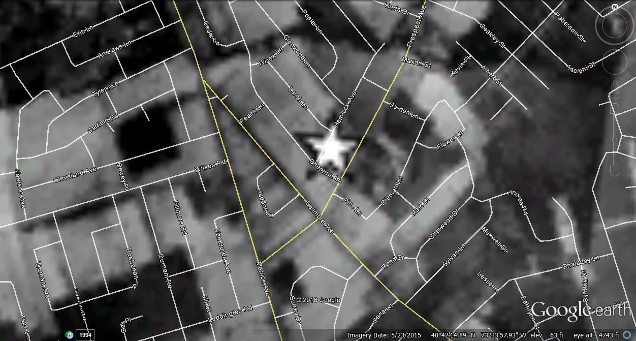
- Bonus: Find the star in the aerial. Whose boyhood home was located here in the 1950s?
The future boyhood home of Howard Kroplick on Hemlock Avenue in East Meadow.
Great job by all this weekend's participants! Congrats to Tim Ivers, Steve Lucas, Art Kleiner, Dick Gorman, Lee Chambers (see Chambers' Clues), Frank Femenias (see Femenias' Findings), Rich, and Greg O.
Kudos to Tim Ivers, Steve Lucas, Art Kleiner, Dick Gorman, Lee Chambers, Frank Femenias (see below very precise overlay) and Greg O. for correctly solving the bonus questions.
Enjoy,
Howard Kroplick
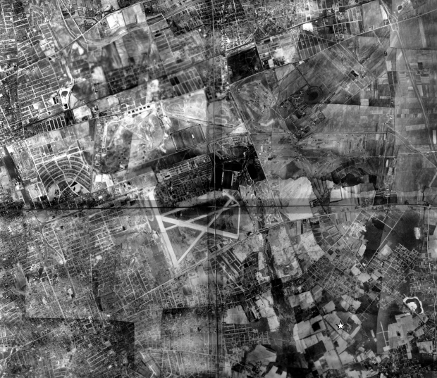
Closeups
Landmarks-South of Old Country Road (left to right): Mineola Fair Grounds, Roosevelt Field, remnants of Vanderbilt Cup Race Course (1936-1937), Roosevelt Raceway.
Below Roosevelt Raceway: Meadow Brook Polo Club
Below Roosevelt Field: Intercollegiate Golf Club/Old Westbury Club
Road surrounding Roosevelt Field: Long Island Motor Parkway. With the exception of the LIRR Motor Parkway Bridge, all the Motor Parkway bridges had been taken down.
Right corner: Mitchel Field
Left Corner: Wheatley Hills Golf Club
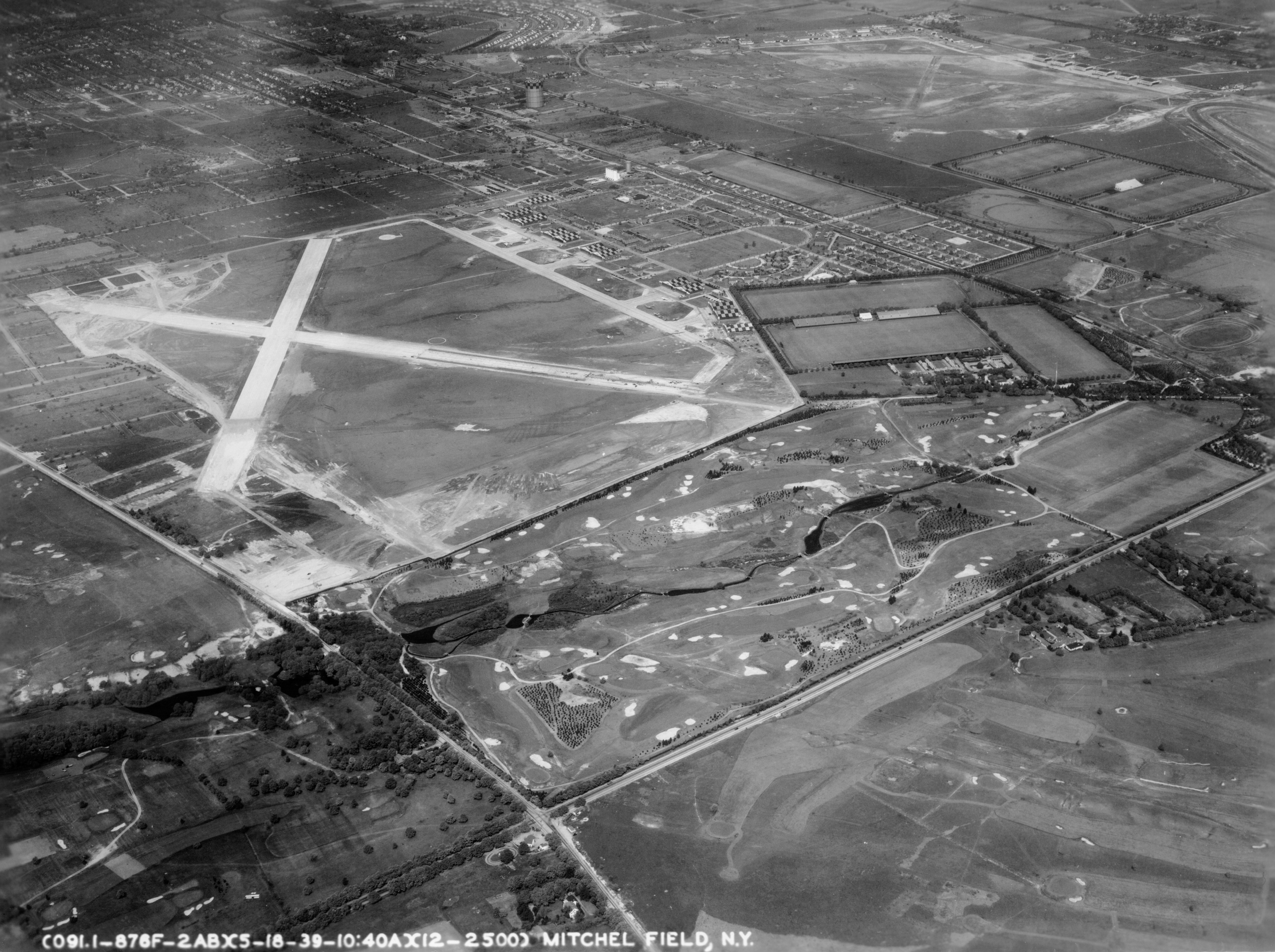
Roosevelt Field, Old Westbury Golf Club and Meadow Brook Polo Club
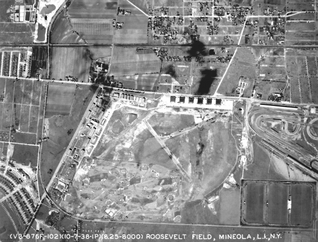
A 1938 aerial of Roosevelt Field showing and intact Long Island Motor Parkway.
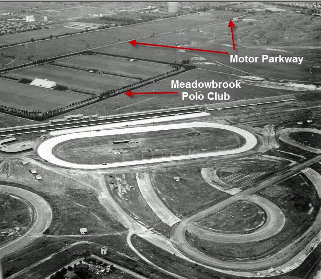
Meadow Brook Polo Club, Roosevelt Raceway and the Motor Parkway
Mineola Fair Grounds
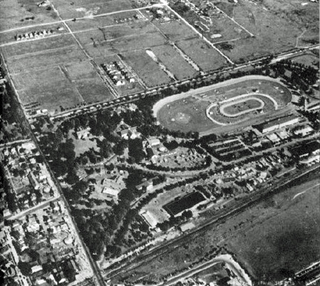
The Mineola Fair Grounds (actually located in Garden City) is now occupied by the Nassau County Court complex.
In June 1946, the Veteran Motor Car Club of America sponsored its 50th Anniversary Jubilee featuring a parade of 75 vintage cars and nine races at the Mineola Fair Grounds on Long Island. Courtesy of Walter McCarthy and the Long Island Old Car Club.
Road across the middle: Long Island Motor Parkway
Landmarks (left to right): Salisbury Golf Club, Ladenburg Estate (see circle)
Bottom left: Mitchel Field, Meadow Brook Golf Club
Mitchel Field, Meadow Brook Golf Club, Salisbury Golf Club, Coldstream Golf Club
Aerial Circa 1941. Note part of a runway was still under construction.
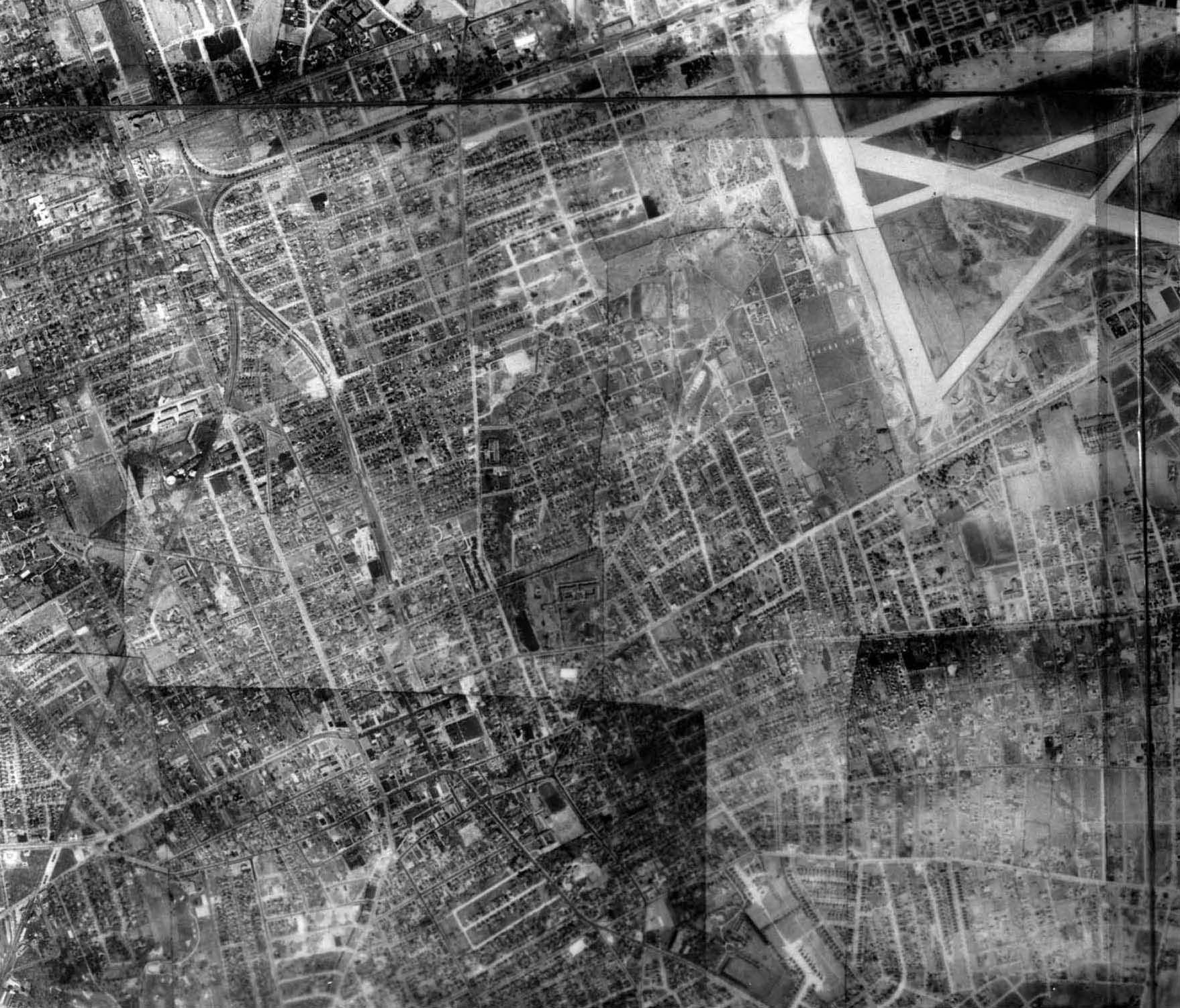
Right corner: Mitchel Field
Left: Hempstead
Left corner: Mitchel Field
Right corner: Meadowbrook Hospital (now Nassau University Medical Center)
Road below Mitchel Field: Hempstead Turnpike- part of the 1904 Vanderbilt Cup Race course
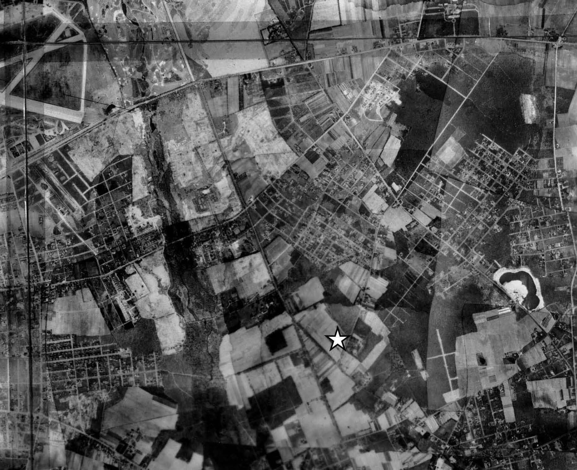
Star: Future boyhood home of Howard Kroplick on Hemlock Avenue in East Meadow. I still remember airplanes flying over my home landing at Mitchel Field (top right corner).
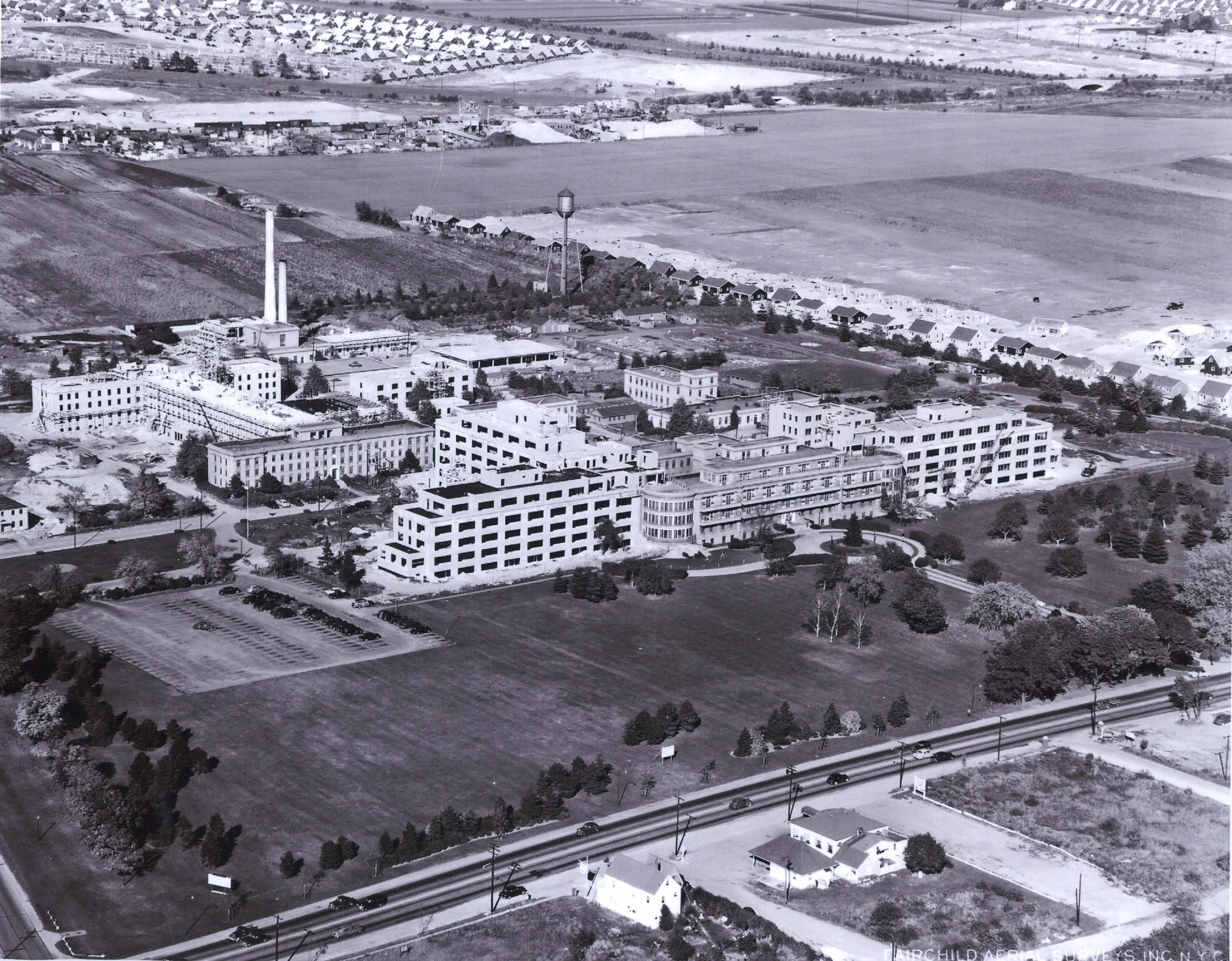
Meadowbrook Hospital Circa 1951/1952. Note the circular driveway.
Hempstead Turnpike can be seen across the bottom.
Chambers' Clues (Submitted by Lee Chambers)
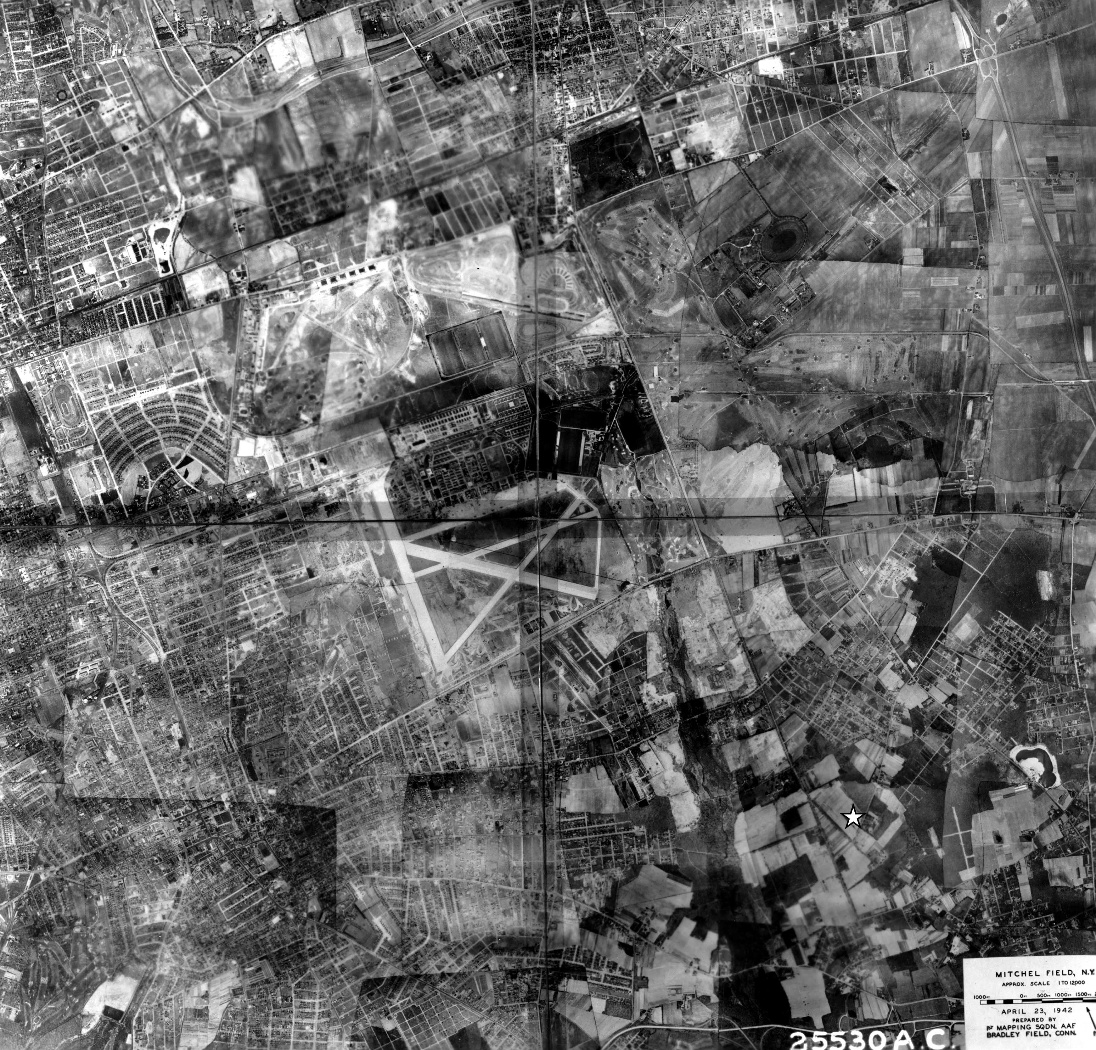
The composite aerials were taken on April 24, 1942.
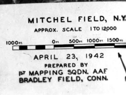
The aerials were taken by the mapping squadron at Bradley Field in Connecticut.
Femenias' Findings (Submitted by Frank Femenias)


Comments
1. At center, the Mitchel Field runways. View is looking north. To the east is East Meadow, south is Uniondale, north is Westbury, west are Garden City and Carle Place.
2. Guessing the year to be 1937 because it looks like Meadowbrook Hospital (1935) in the upper right.
3. The LIMP is seen curving around the western edge of Roosevelt Field then running east across Merrick Avenue, curving again around Ladenberg’s estate in Salisbury (Eisenhower) Park.
4. The Coldstream and Salisbury Links are visible to the right of Mitchel Field (divided by Merrick Avenue) and the golf course at the southwest edge of Roosevelt Field is also visible.
5. The star appears to be the future home of Howard Kroplick, in East Meadow.
This photo was taken over East Meadow, Uniondale, Westbury, and Carle Place. It also includes parts of Garden City, Hempstead, West Hempstead, Mineola, and Levittown (then Hicksville). It probably dates from 1940 because you can see early Roosevelt Raceway (harness track) but remnants of the 1936-1937 Vanderbilt Cup Roosevelt Raceway are also visable. Among the LIMP landmarks are the sites of 13 bridges: Wheatley Hills “golfway”, Hillside Ave, Westbury Ave, LIRR Mainline, Old Country Road, Clinton Road, Rosevelt Raceway access, Merrick Ave, Newbridge Ave (Bellmore Rd), Stewart Ave, Carman Ave, Old Westbury Road, and Newbridge Road. Also, the Garden City and Meadowbrook Lodges. Sports venues include the following golf clubs:Coldstream, Wheatly Hills, Meadowbrook, and Salisbury (later Eisenhower Park). The Meadowbrook Polo Club is also visable. In the center of the photo are two other landmarks: Mitchell Field and Roosevelt Field, the site of where Lindbergh began his famous flight. With regard to the star in the lower right area, I believe it indicates the location of another famous landmark: the Hemlock Avenue boyhood home of the North Hempstead Town Historian.
Thanks for this mystery photo, Howard, to keep us busy during the snow fall!
Identify the villages in the aerial: Garden City, Mineola, Carle Place, E. Williston, Williston Park, Westbury, Uniondale, East Meadow and partially today’s western most part of Levittown (another couple of feet on the east side of the map would have shown where I currently live).
What is the approximate year of the aerial? Provide a rationale.:
I estimate the date to be between 1944 and 1948. Three runways in Mitchell Field are present which are seen in photos after 1940. Also, looking at the houses on Transverse Road in Garden City, #75 (built in 1948) is not shown in the photo but #73 is shown (built in 1944). Will provide Howard a map designating this. Using the Nassau Tax Assessor’s website, I was able to identify these properties on the mystery photo and find their dates of construction.
Identify the Long Island Motor Parkway landmarks:
Not sure of what’s still shown in the photo (my eye sight is not so great at picking out bridges and some might have been taken down by then) but there would be the Roosevelt Field Bridge, Merrick Ave., Meadowbrook lodge, Westbury, Carmen Ave., Newbridge Ave., and Stewart Avenue Bridges. Also the Garden City Lodge.
Identify the golf course and sports venues: I can pick out the Meadowbrook, Intercollegiate/Old Westbury, Wheatley Hills and Salisbury Golf Courses. Cold Stream Golf also might be present but not sure if it was still in existence at the time.
Also the Roosevelt Field harness and auto tracks, the International and Meadowbrook Polo Fields and the Mineola Fair Grounds and race track.
Identify any other Long Island landmarks: Meadowbrook Hospital, Nassau County Courthouse and the Ladenberg Estate.
Bonus: Find the star in the aerial. Whose boyhood home was located here in the 1950s? No other than Howard Kroplick’s boyhood home.
Forgot to mention in my earlier entry the Northern and Wantagh State Parkways.
Hempstead, Hicksville, Uniondale.
Salisbury Golf course,
Mitchel Air Force Base, Roosevelt Raceway
Boyhood home of Howard Kroplick?
From Lee Chambers:
I suppose I have an unfair advantage with Mystery Foto #4. It’s obviously an aerial of Mitchel Field. I can easily pinpoint my house at 363 Rice Circle, which at the time was the Commanding Officer’s Quarters.
Notice how all the runways including the North / South one that runs parallel to Oak Street have been completed. The two main runways forming the ‘X’ were built in 1939, the one running parallel to Hempstead Turnpike in 1941 and the one parallel to Oak Street in 1943. In fact, the date of the photo is April 24, 1943 and is attached.
Roosevelt Field is to the Northwest, East Garden City to the West, Uniondale to the South, East Meadow to the East and Westbury to the North.
The star is sure to be the house you grew up in!
Now the Extra Bonus Question - What was the approximate elevation the photo was taken from?
Pre 1956, no Meadowbrook Pkwy. Roosevelt Field with hangars by Old Country Rd and horse stables, Mitchell Field fully developed, Polo fields adjacent to Motor Pkwy, the LIMP travelling north to south through Wheatley Hills golf course, over Hillside Av, under Jericho Tpke (Mineola Lodge), under Westbury Av, over the LIRR bridge, under Old Country Rd, through the Mayan Ruins, sharp left over Clinton Rd (Garden City Lodge and the Manager’s house). By the way, it was the manager’s house where I saw a pic of a weather vane on its roof that was a racing car, but nothing like that humongous copper racer that was recently found. I was unable to find that photo again.
The star in the aerial is the former site of Farmer Kroplick’s barn where cattle and horses were raised. It was reported that a motor garage existed semi attached to the barn on the same site. This garage was frequented by Vanderbilt Cup Racers and their racing machines, seeking cutting edge technology to soup-up their machines before the big race, which was performed all hours of the day and night by mechanician Sam Greco. The farm/garage was located at today’s (two possibilities) Larch Ln between Hemlock Av and Willow Ln, or less likely Prospect Av between Chestnut Ln and Garden Ln. (was I right?). Too much fun Howard, thank you.
Hemlock Av between Larch Ln and Chestnut Ln.
The runways look like old photos of Mitchell Field, but I can’t recognize any other landmarks!
Identify the villages in the aerial
Starting in the upper left moving clockwise; Mineola, Carle Place, Westbury/Salisbury, East Meadow, Hempstead, Garden City
What is the approximate year of the aerial? Provide a rationale. 1943/44
Judging by the Wantagh, Northern and lack of Meadowbrook parkways and Mitchel runway configuration
Identify the Long Island Motor Parkway landmarks
Too many bridges and lodges to list! Many of the bridges are gone since this aerial is after the LIMP closed, but it starts at the very top edge with the LIMP golfway bridge in the Wheatley Hills Golf Club in East Williston to just after the LIMP Westbury Road Bridge in East Meadow and the 1938 Robert Moses bridge over the Wantagh Parkway at the very right edge of the photo.
Identify the golf course and sports venues
Ha! Which one? The photo is littered with sports venues/polo clubs and golf courses! I’ll just refer to the website;
http://www.vanderbiltcupraces.com/blog/article/the_golf_courses_adjoing_the_long_island_motor_parkway
Identify any other Long Island landmarks
Bonus: Find the star in the aerial. Whose boyhood home was located here in the 1950s?
I’m going out on a limb for this one and say this was your home Howard!
Hay guys,you all really know your stuff,great job on this one,don’t know how you do it. I recognize some of the photos, seen them so many times but don’t know where they are,so don’t even bother answering,just wait and see what the answers are and marvel at the amazement of it all. One last thing. One last thing,I hope all is well after the storm. We were very lucky here,only got about 4 inches. I know it was bad it was bad in some places