Mystery Foto #63 Solved: The Abandoned Motor Parkway and North Hempstead Turnpike in Fresh Meadows
Sam Berliner III, the convenor of the Long Island Motor Parkway Panel, forwarded this week's Mystery Foto of Fresh Meadows.
Mystery Foto questions:
-Identify the location of the aerial
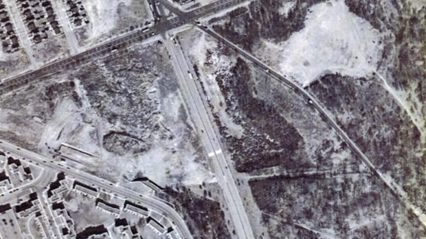
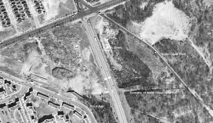
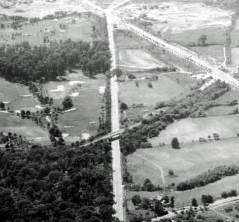
Fresh Meadows with Francis Lewis Boulevard in the middle and Nassu Boulevard across the top
-What are the abandoned roads in the aerial?
The Long Island Motor Parkway, North Hempstead Turnpike and sections of Hollis Court Boulevard.
-What other structure(s) can also be seen ?
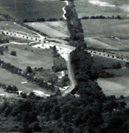
Remnants of the North Hempstead Turnpike Motor Parkway Bridge can be seen above the curve at Peck Avenue (see Sam Berliner III's captions below).
-What is the approximate date of the aerial? Explain your reasoning.
1948-1954 based on remnants of the North Hempstead Turnpike Bridge and the absence of PS179 built in 1955.
Congrats to Joe O., Mitch Kaften, Roy Warner, Greg O., Frank Femenias and Brian McCarthy for solving the Mystery Foto.
Enjoy,
Howard Kroplick I
Fresh Meadows captions provided by Sam Berliner III.
Similar Fresh Meadows Views
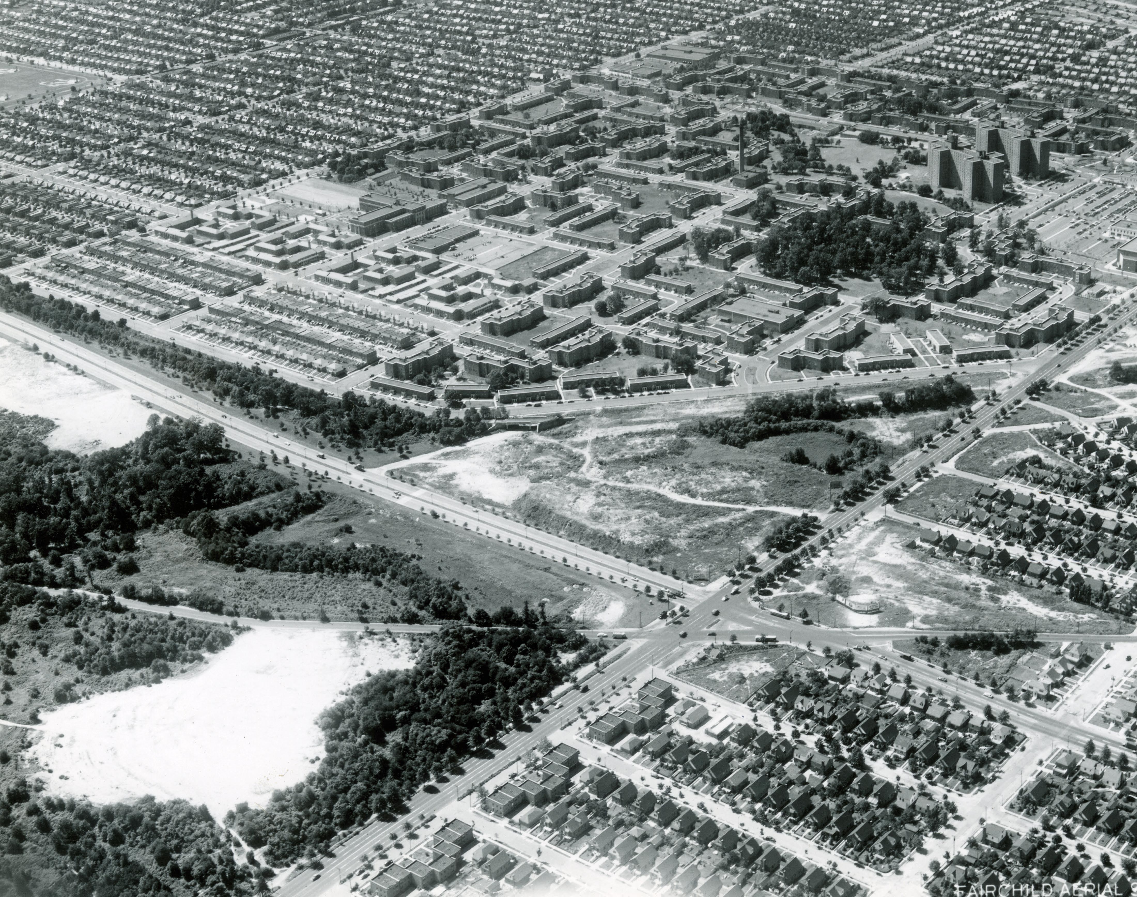
June 24,1938: Looking north.
1938
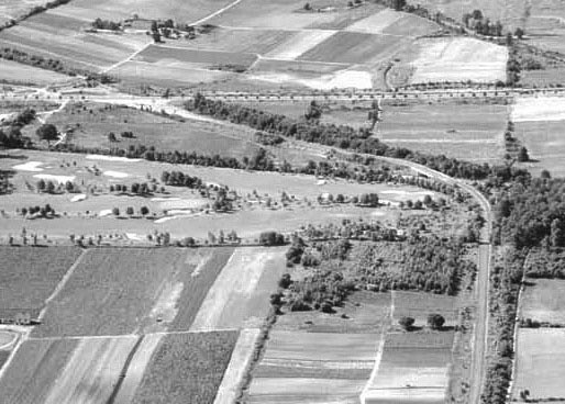
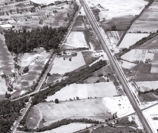
June 2, 1939: Looking west with the North Hempstead Turnpike Motor Parkway Bridge in the middle of the aerial
June 2, 1939: Looking north
July 23, 1939: Looking west at Nassau Boulevard (right), the North Hempstead Turnpike (left) and the Motor Parway and the Western Terminus (diagonally across the middle).
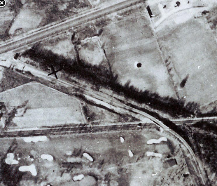
1948: The northern embankment of the North Hempstead Turnpike Bridge was taken down in the 1940s as shown in this aerial looking south and west, courtesy of New York Life Archives.
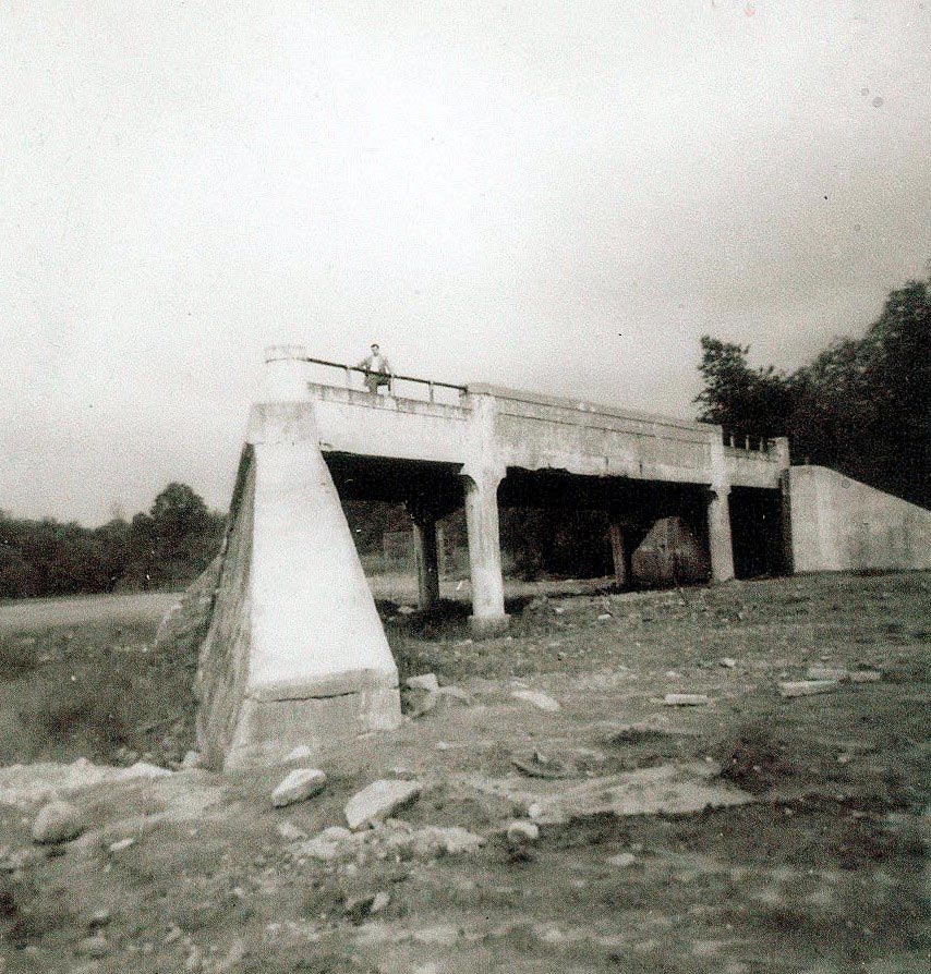
1950s: North Hempstead Turnpike Motor Parkway Bridge (courtesy of Robert C. Levine).


Comments
LIMP Western Terminus, Fresh Meadow. North Hempstead Turnpike, abandoned. Hollis Ct Blvd, abandoned. I think you can also see part of the old LIRR, also abandoned. LIMP bridge over NHT is there. Picture appears to be at least the 1940’s, after the parkway closed.
-joe o
Hi Sam!
This is Fresh Meadows, Queens, near the final terminus of the LIMP. Horace Harding Blvd runs left to right across the top. Francis Lewis Blvd runs top to bottom. Hollis Court Blvd runs top to right diagonally. Fresh Meadows housing development in the lower left.
Abandoned roads: North Hempstead Turnpike and Hollis Court Blvd (also a smidge of the Creedmoor Parkway right-of-way for the abandoned Stewart rail line).
Other structures: North Hempstead Turnpike LIMP overpass.
Approximate date: 1948. Construction of Fresh Meadows was completed in about 1948; LIMP overpass was removed in about 1955, with the completion of PS179, which does not appear here.
The only thing I’m wondering about is, what are the two parallel lines in the upper left, at the foot of 64th Avenue: the foundation for PS179 or the remains of the LIMP?
The two roads: Hollis Court Blvd. and North Hempstead Tpke.
This is very near where I grew up as a boy in the 50s. The intersection ws between Horace Harding Blvd., Francis Lewis Blvd. and Hollis Court Blvd. Hollis Court Blvd. through the intersection was eliminated when the LIE and Clearview Expressways were built. The remains south of the area became Hollis Court Terrace. The LIE and Clearview at this location opened in 1960. N. Hempstead Tpke. was cutoff when Fresh Meadows was built in the late 40s, although the remains continued north of Horace Harding Blvd (LIE). The name was changed to Booth Memorial Ave sometime later. I remember my 5th grade teacher taking us on a field trip to the construction site in 1958.
May be way off but here goes:
Glen Oaks, circa40s, early 50s, following construction of Glen Oaks Village.
Abandoned Motor Parkway and Underhill Avenue?
-Identify the location of the aerial.
The LI Motor Parkway Western terminus in Fresh Meadows…or at least it used to be.
-What are the two abandoned roads in the aerial?
The Motor Parkway and North Hempstead Turnpike…and the eventually-to-be demolished Hollis Hills Terrace when the Clearview Expy gets built.
-What other structure(s) can also be seen ?
The North Hempstead Turnpike LIMP Bridge
-What is the approximate date of the aerial? Explain your reasoning.
Francis Lewis Blvd, Peck Ave. and the apartments to the West all were built in the early 40’s as was the northern embankment of the bridge taken down, so my guess is 1948-ish since there looks like more overgrowth in 1951 aerials.
Motor Parkway Western Terminus, Fresh Meadows facing North. Tree-lined Horace Harding Blvd (Nassau Blvd) on the top left. Abandoned are Motor Pkwy, North Hempstead Tpke (Booth Memorial Ave), and the N Hemp Tpke LIMP parkway bridge (1926-1955/6). Hollis Court Blvd (Queens Rd) still in one piece on the right side of this aerial. Francis Lewis Blvd (Cross Island Blvd) and Peck Ave’s are present. The Fresh Meadows apartments (1950) replaced the Fresh Meadows golf course. P.S. 179’s (P.S. 4) building foundation (1955) in the process of being set. I’d say this is approximately 1955.
Well, this is Fresh Meadows. The 2 roads that are certainly abandoned for automobile traffic are the LIMP and N Hempstead Tpke. You can see the path remnants of the tpke on both sides of Francis Lewis Blvd going east into Cunningham Park, and west under the LIMP overpass. That path angling west and east south of the tpke must be the Central RR remnants. Approx. 1950, well after the LIMP was in operation. And from what I read, the LIMP overpass was demolished later in the 50’s. If this photo was near 1960, you would see the Clearview Expressway cutting through Cunningham Park, east of Francis Lewis Blvd. The portion of Hollis Court Blvd that angles north and south would be taken over by the Clearview, too.
This is another one wouldn’t of gotten, so I didn’t even bother with it
! Mitch Kaften’s photo of the boys playing baseball, north of Holy Cow Park was taken in 1955, with the LIMP’s N Hemp Tpke bridge still erect in the background !
I was curious to know how far east N Hempstead Tpke extended originally. According to a 1947 topo (historic aerials), it terminated at Hollis Court Blvd.
Brian: I checked a 1924 aerial and it showed the same. http://www.vanderbiltcupraces.com/blog/article/mystery_foto_friday_17_identify_this_future_location_of_the_long_island_mot
Seems odd such a busy roadway to terminate so abruptly like that. Hard to imagine even eastern Queens at some point was as rural as the eastern counties