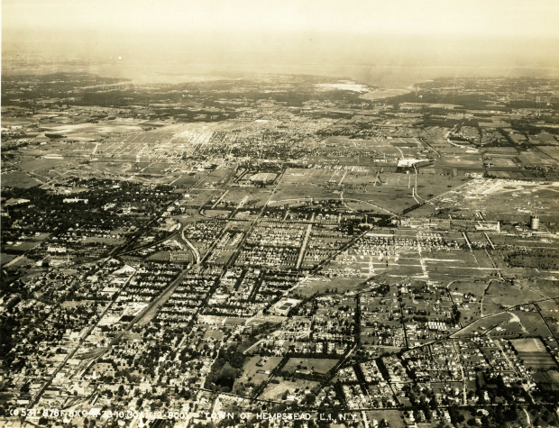
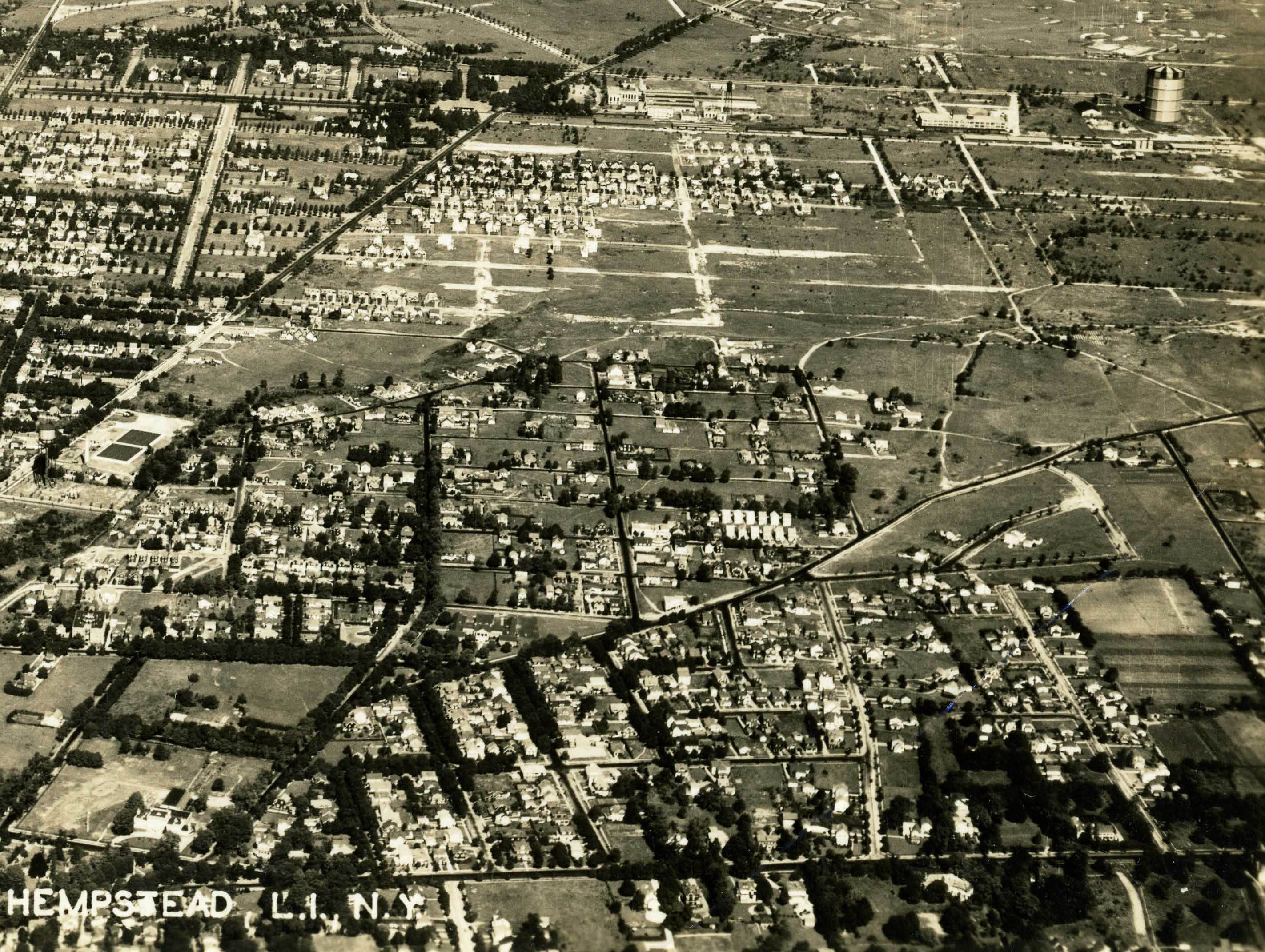
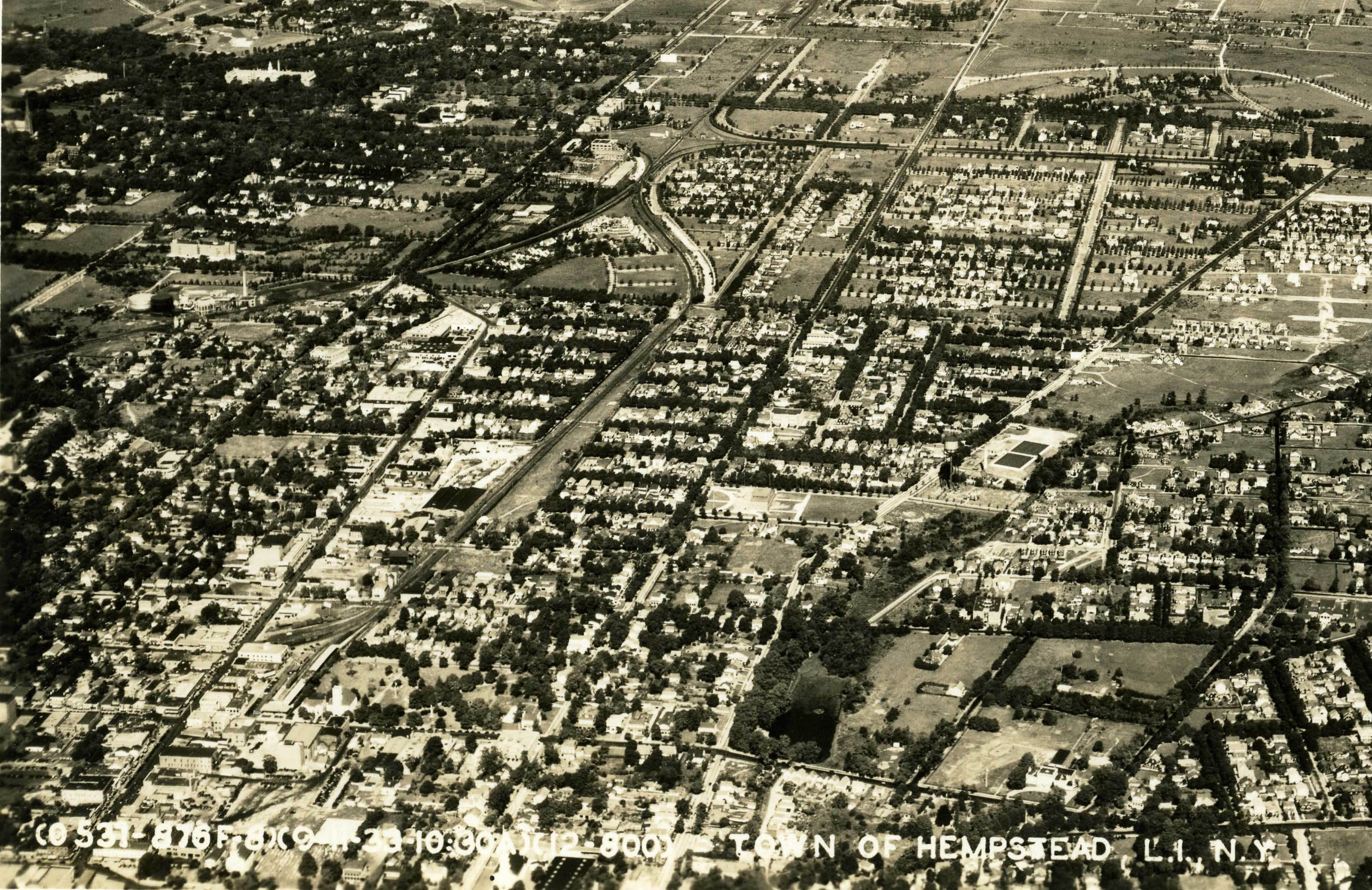
Mystery Foto #73 Solved: A Spectacular 1933 Aerial of Hempstead and North Hempstead
Gary Hammond forwarded this amazing aerial for this weekend's Mystery Foto. Photo courtesy of the Hammond Collection.
Mystery Foto questions:
-Describe the location and orientation of the aerial
Looking north from Hempstead towards North Hempstead and the Long Island Sound
-What is the date of the aerial?
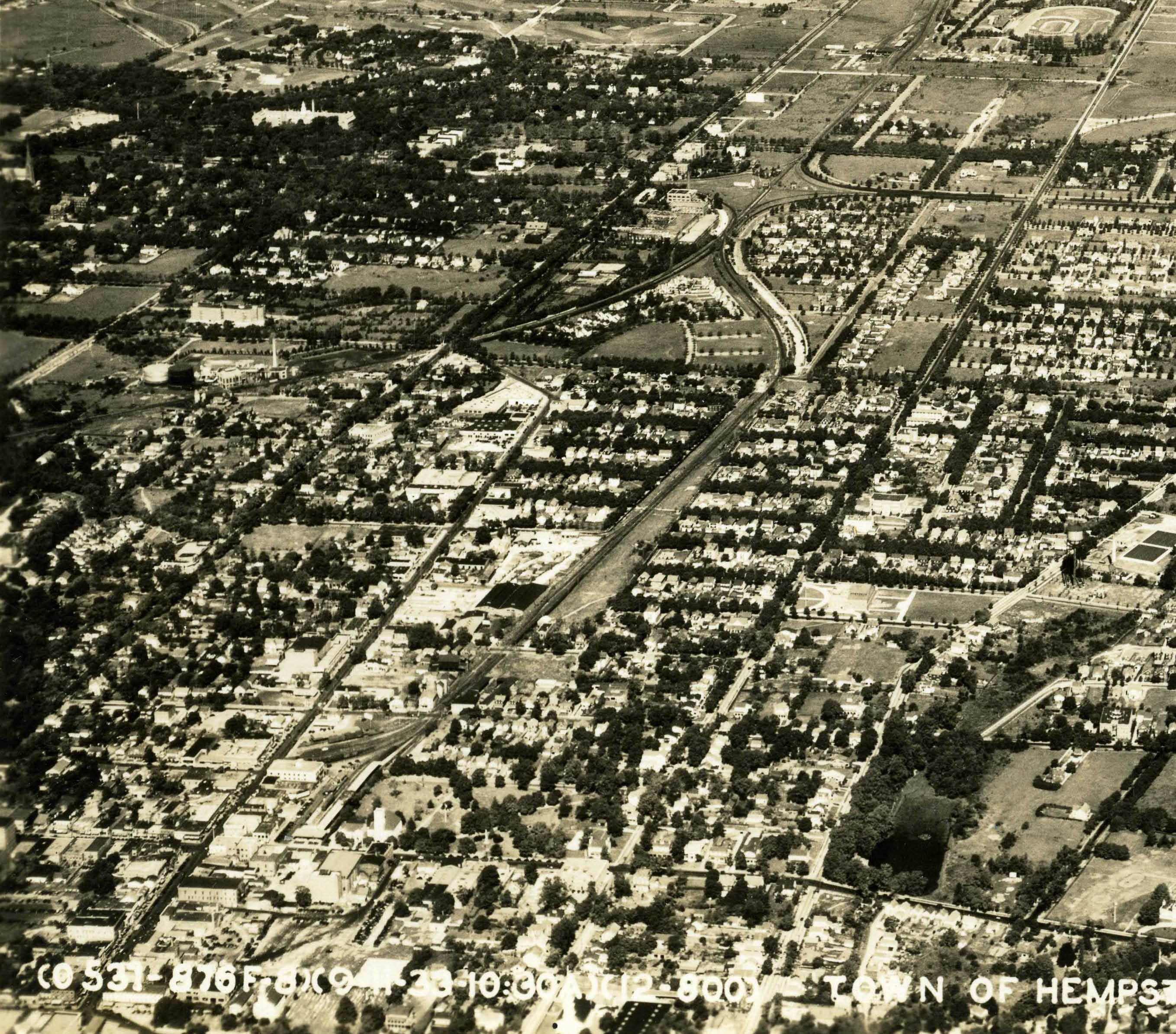
Date and time of the aerial was provided on the left corner of the aerial: September 11, 1933 at 10:30 AM
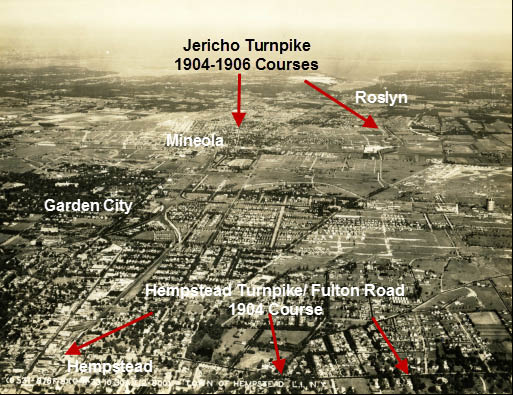
-List the Long Island Motor Parkway and Vanderbilt Cup Race landmarks (a special kudo for the largest number identified)
Vanderbilt Cup Races
Garden City Hotel- Headquarters for the Vanderbilt Cup Commission (1904-1910)
Jericho Turnpike- Part of the race courses (1904, 1905, and 1906)
Hempstead Turnpike/Fulton Road- Part of the 1904 race course.
Long Island Motor Parkway
Bridges (8)
Wheatley Hills “Golfway” Bridge in East Williston
Hillside Avenue Parkway Bridge in East Williston
Jericho Turnpike “Highway” Bridge in Mineola
Westbury Avenue Parkway Bridge in Mineola/Carle Place
Mineola LIRR Motor Parkway Bridge
Old Country Road Highway Bridge
The “Mayan Ruins” Motor Parkway Bridge in Garden City
Clinton Avenue Motor Parkway Bridge in Garden City
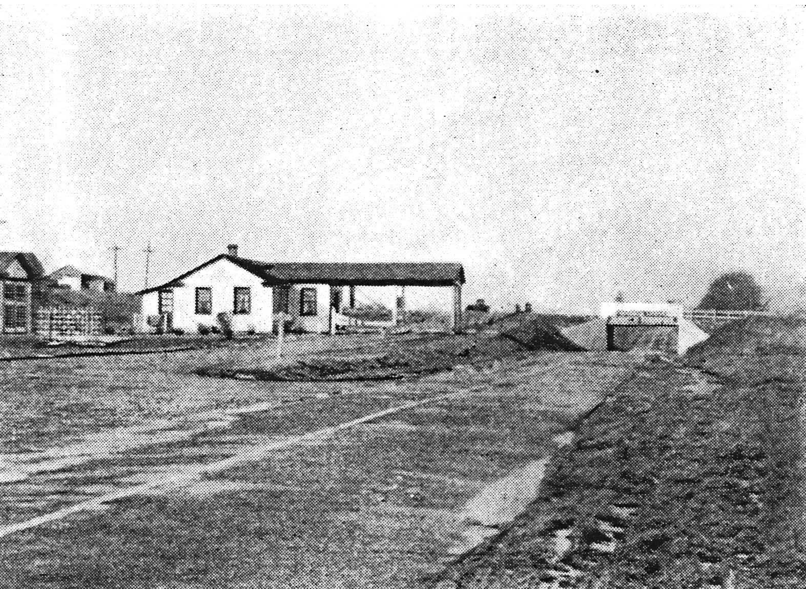
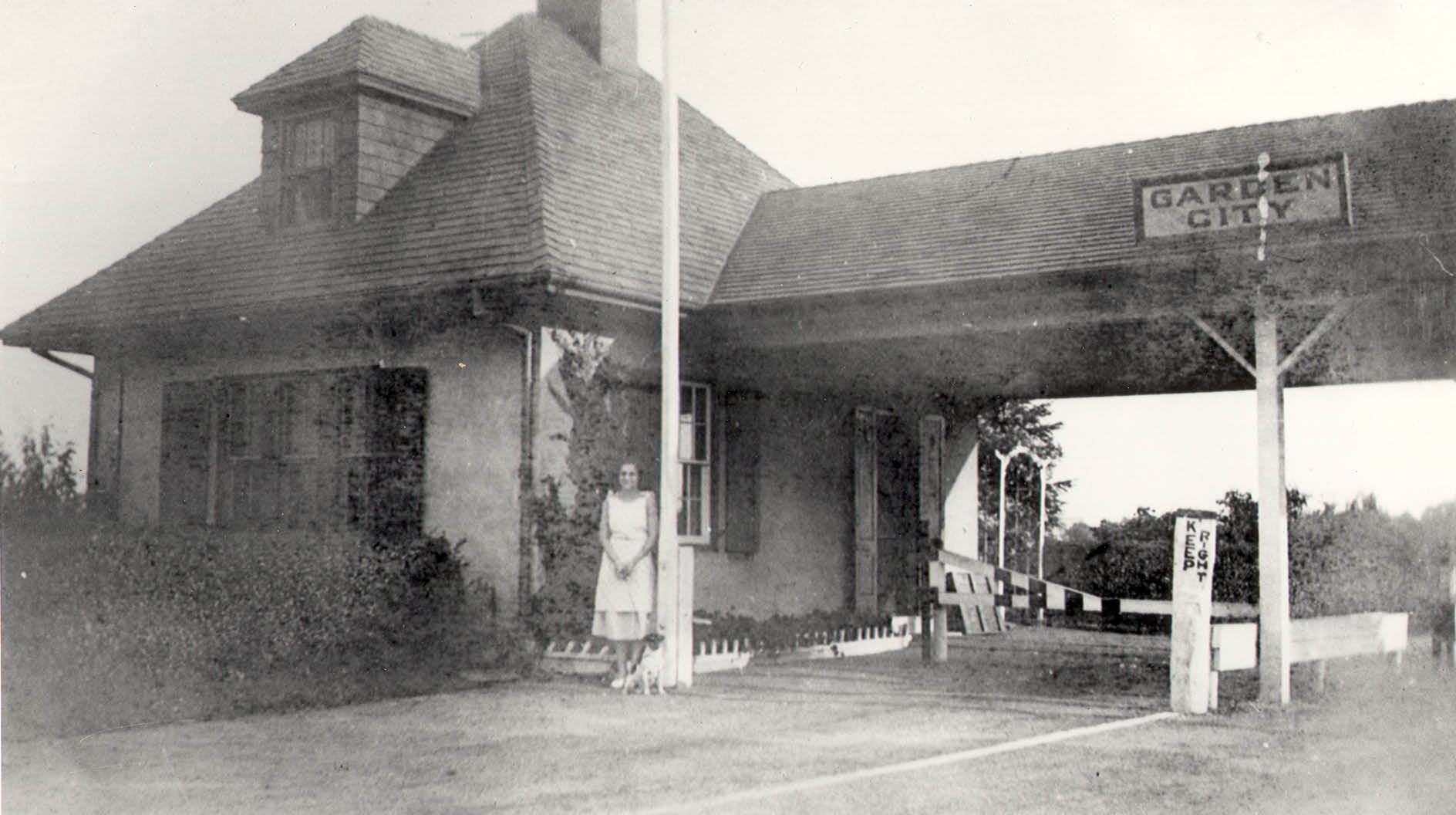
Lodges (2)
General Manager's Office in Garden City
-List other Long Island landmarks
Gary Hammond's key for identifying the aerial's landmarks.
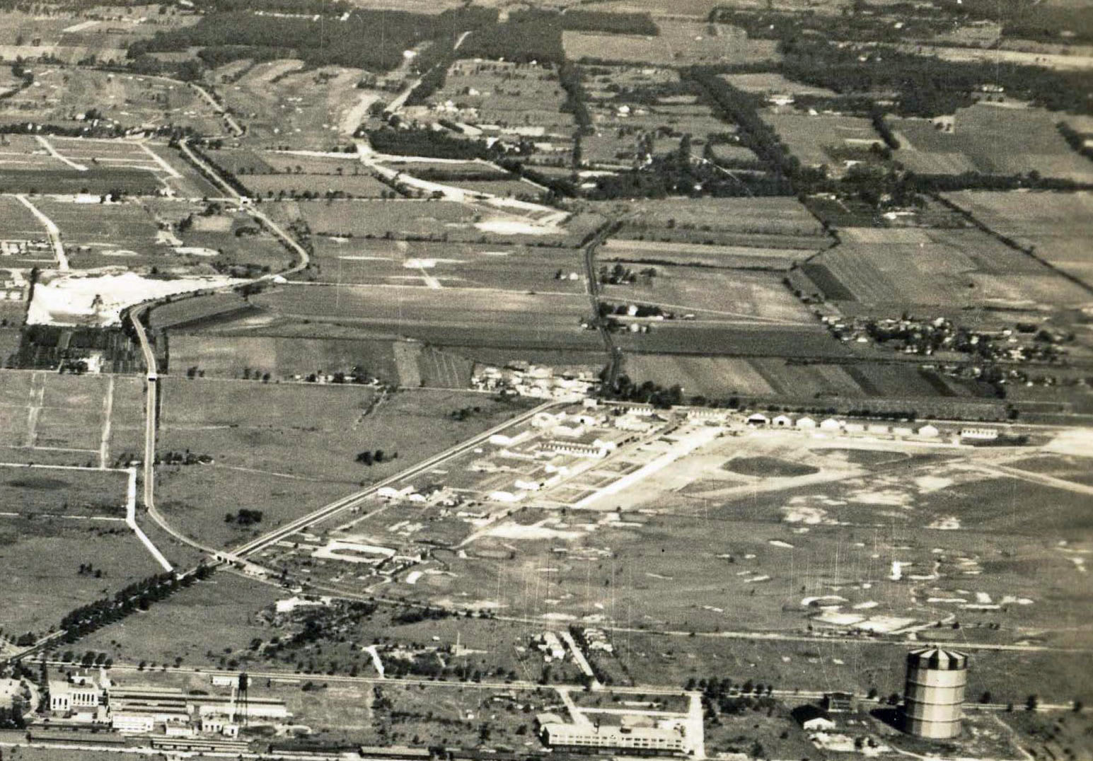
Aerial Photograph of Village of Hempstead North to L.I. Sound
Taken September 11, 1933 at 10:30 AM
-Looking North
-Village of Hempstead on bottom left corner, w/Fulton Ave./Hempstead T’pke running left to right parallel to bottom edge
-LIRR Hempstead Station ends at Fulton Ave., just west (left) of Christ’s 1st Presbyterian Church; slightly above them is the old LIRR freight yard
-Just above the center of the photo is the Mineola Fairgrounds (built 1866) w/ its oval race track – Now the site of the Nassau County Court Complex
-Roosevelt Field is to the right of center, w/the hangars running along Old Country Rd (prior to 1929 it was Curtiss Field, where Lindbergh’s plane was housed prior to his Transatlantic flight)
-Right side center is the old LILCO gas tank, along Stewart Ave. (which was both a landmark and obstacle for the aviators at Roosevelt Field); left of the gas tank on Stewart Av. is the bldg. now used by the -1st Marine Corps District Headquarters Recruiting Command (605 Stewart); left of that is the Curtiss Engineering Corp. bldg. (later Oxford Pendaflex, now Nassau BOCES)
-Just south (below) of Curtiss plant is Commercial Ave. w/wooden WWI warehouses (some still were there as late as the 1980’s)
-Top center is Roslyn Harbor, opening into Hempstead Bay; on the left of that is Manhasset Bay
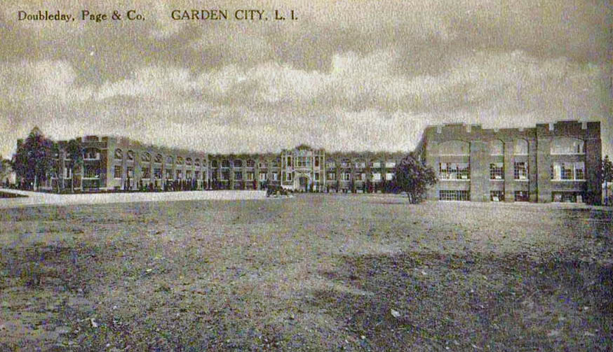
-Left of center, adjacent to the old Doubleday Plant is the where LIRR branches crossed, going N,S,E, & W. East was the original Central RR going to Farmingdale in the 1870’s, at this time it went through Mitchel Field, and prior to the building of Meadowbrook Pkwy; West goes through Garden City; North went to Mineola (parts of the abandoned right-of-way still were undeveloped recently); South goes to Country Life Press then to Hempstead, and veering off to the southwest (left) is the line that went to West Hempstead (see Art Huneke’s website www.arrts-arrchives.com for in-depth discussion & photos of this)
-Curved road in center is Osborne Rd, Garden City
-Oak St. doesn’t yet go through from Commercial Ave. to Hempstead Turnpike
-Westbury Blvd. is angled road running from bottom center going to the right
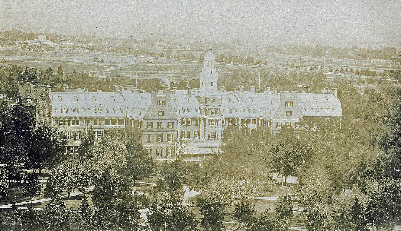
-Left of center, near edge is the Garden City Hotel, surrounded by trees
-Road N to S (top to bottom) center is Washington Ave., to the left the next main road is Franklin Ave.
-Of course the LIMP – Clinton Rd Bridge & Office Bldg & Garden City Lodge; Old Country Road Bridge; Jericho Tpke Bridge
-White area near top center is the Port Washington sandpits along the west side of Hempstead Harbor
-Left edge center is the Cathedral of the Incarnation, Garden City
Congrats to all 14 participants in this week's Mystery Foto contest. Kudos to Art Kleiner for identifying 26 Long Island landmarks.
Speical kudos to Gary Hammond for submitting this amazin aerial and providing the "key".
If you have a suggested Mystery Foto, please email it to me at [email protected] .
Enjoy,
Howard Kroplick
Vanderbilt Cup Race Courses
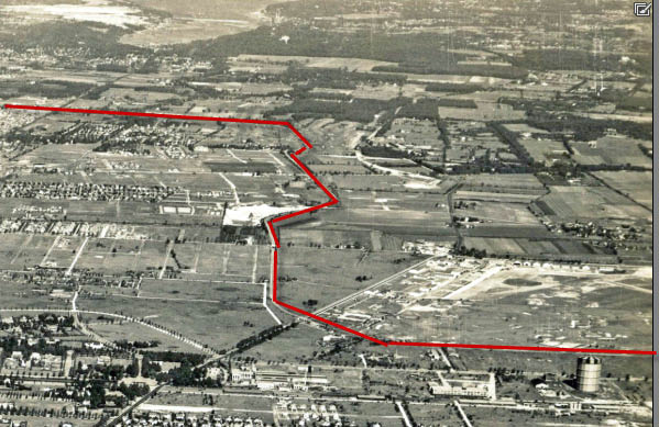
Visible sections of the Long Island Motor Parkway
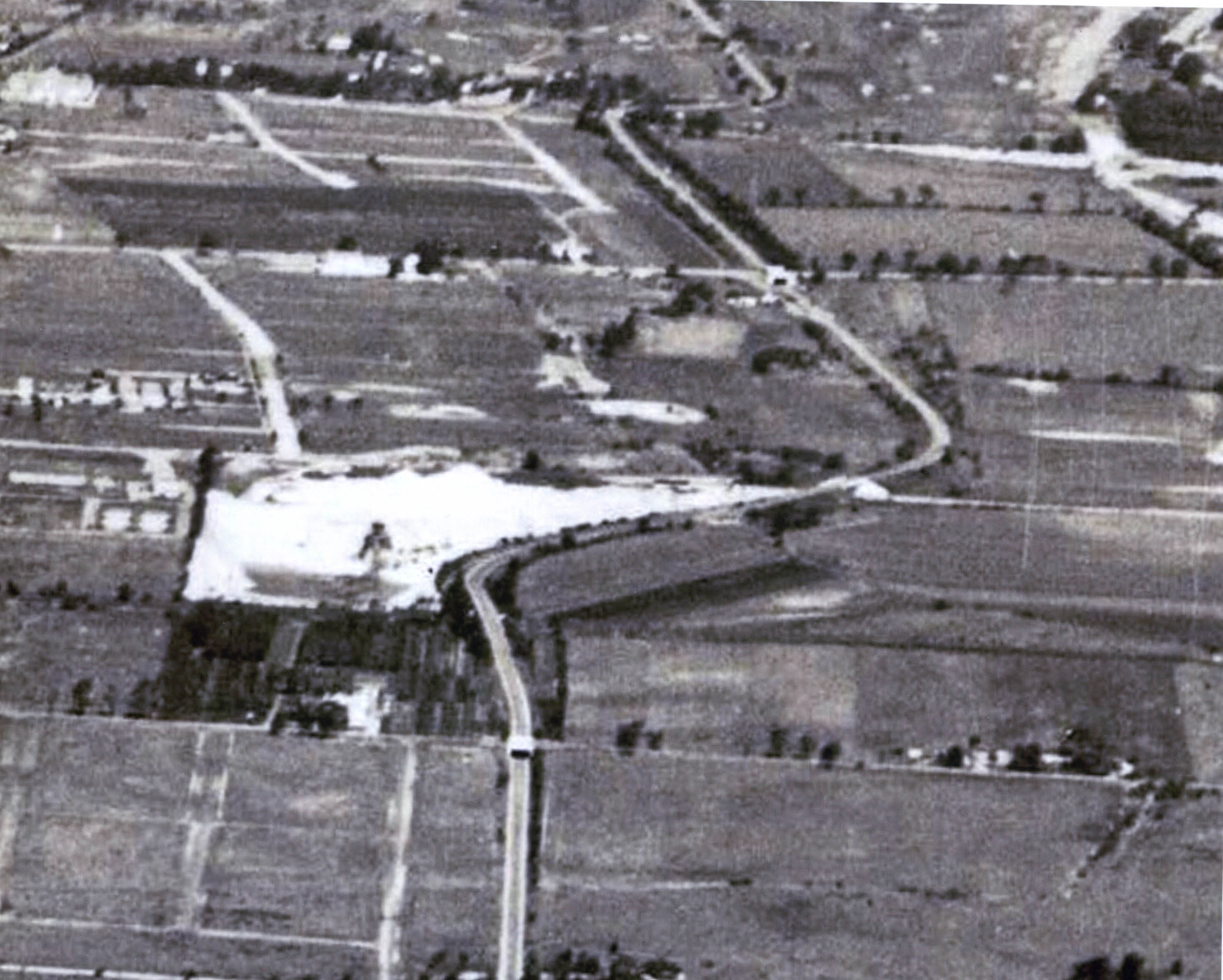
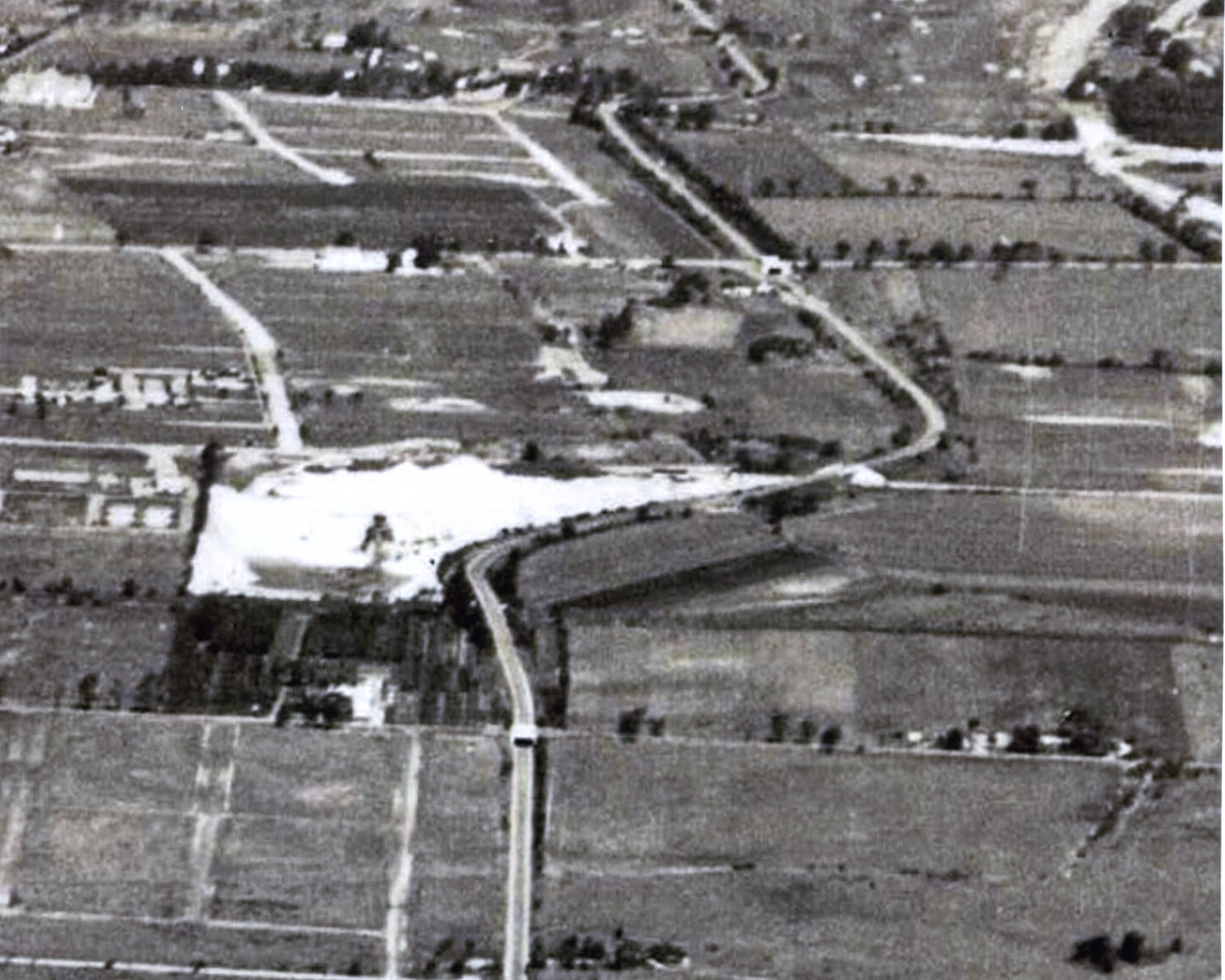
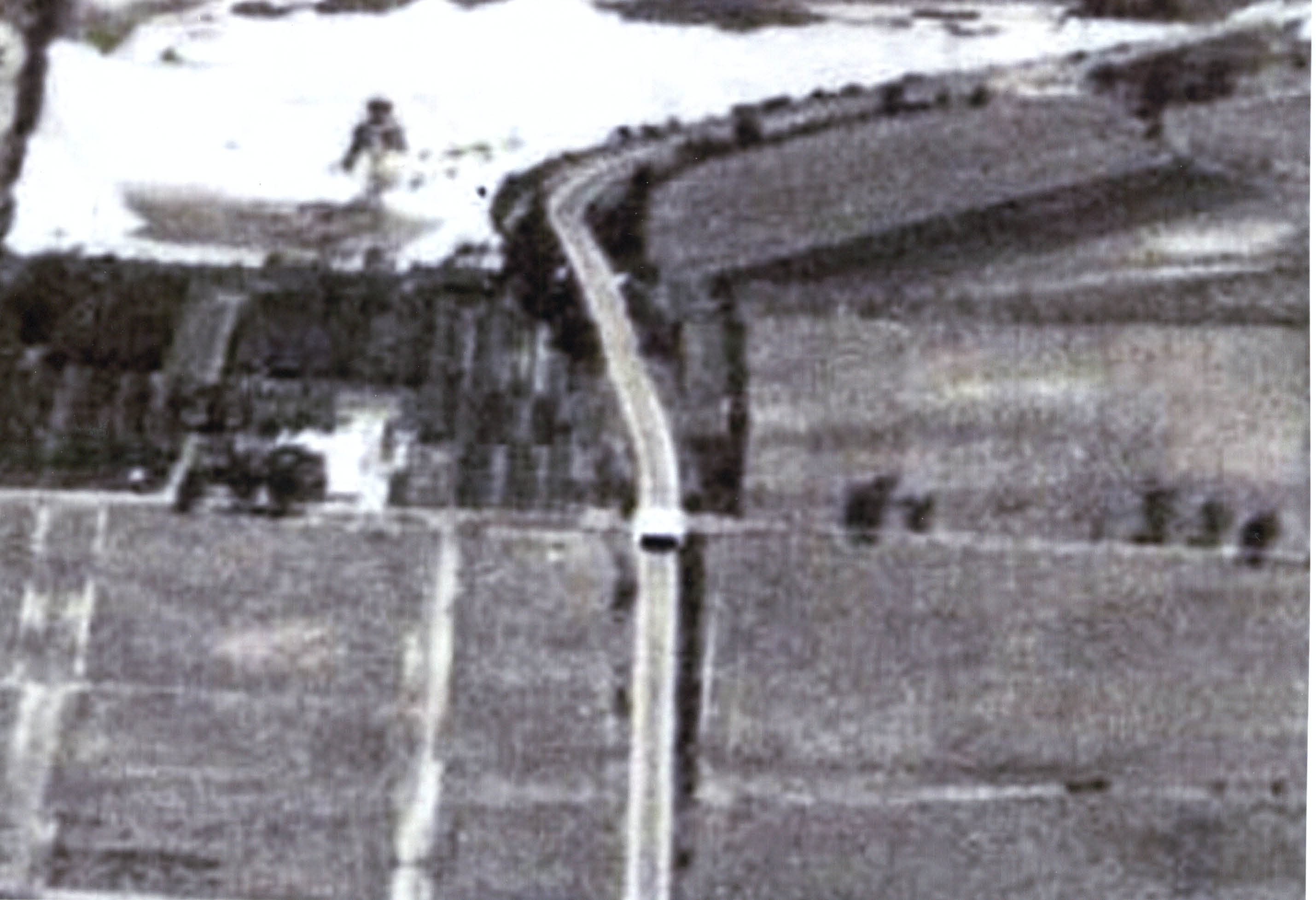
Close-Ups: Right Side (Top to Bottom)
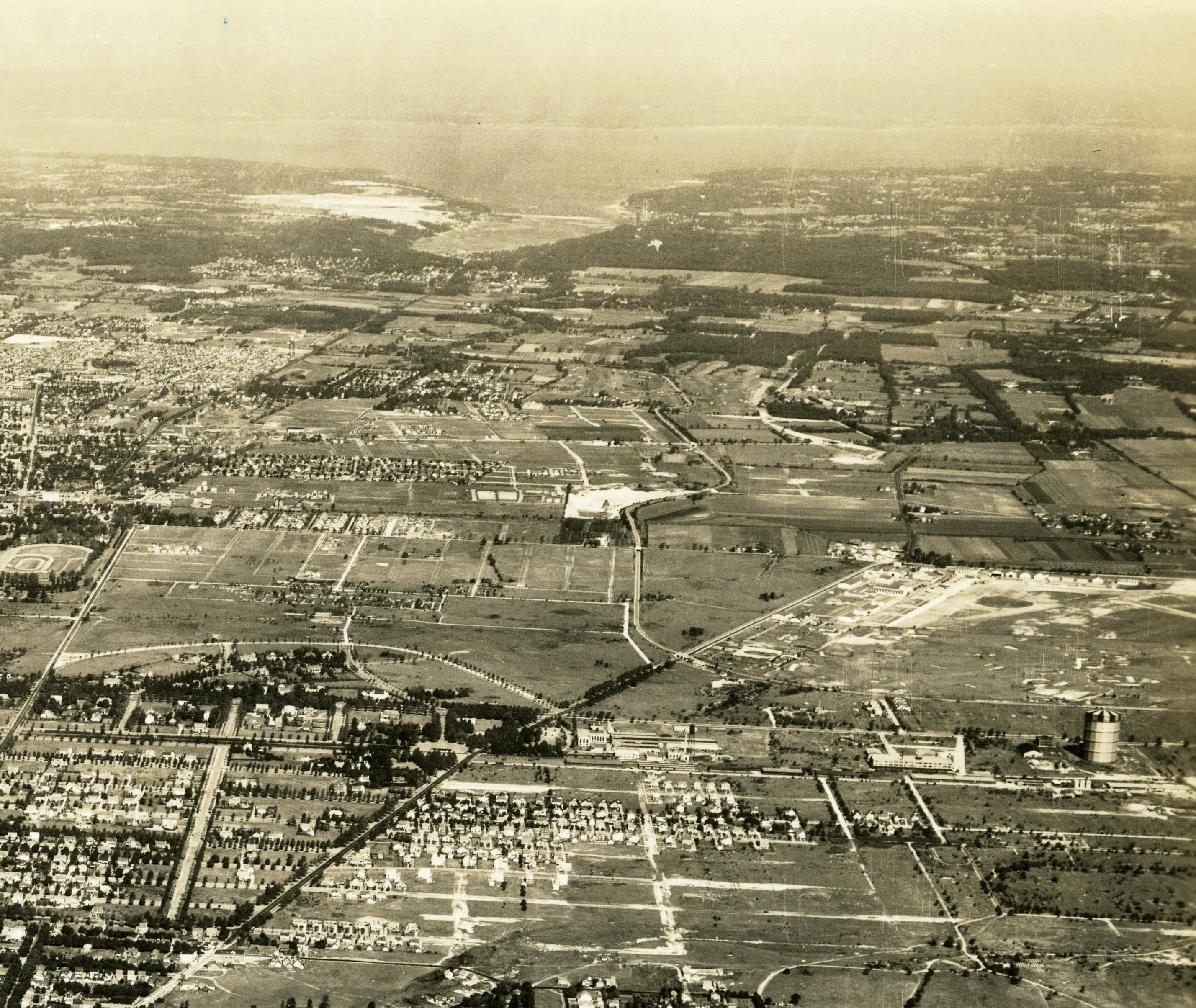
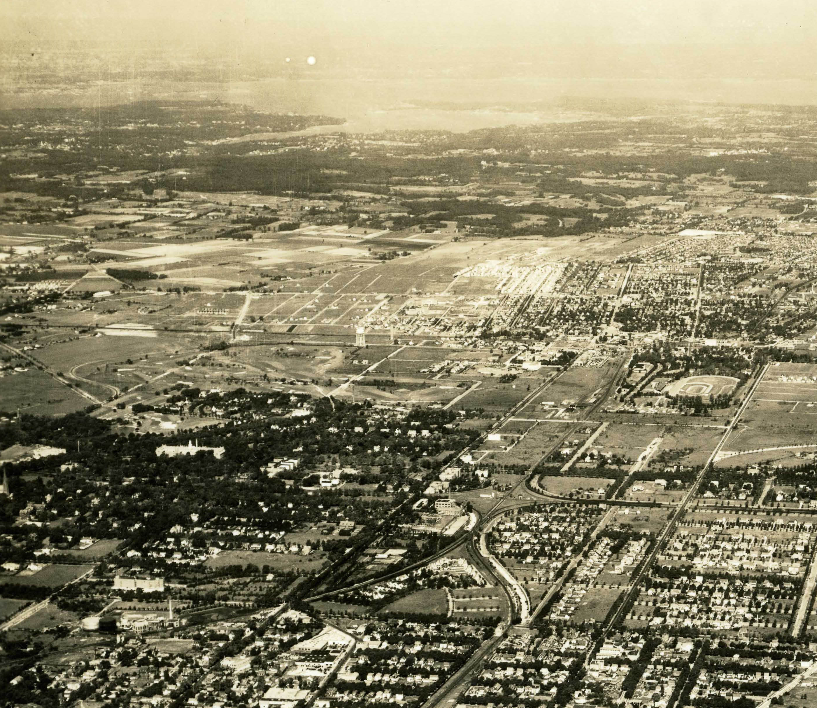
#1 Looking north from Hempstead to Hempstead Harbor in North Hempstead. White area on top are the Port Washington sandpits. The large building on the hill east of Hempstead Harbor is Clarence Mackey mansion appropriately named "Harbor Hill".
#2 Roosevelt Field, Old Westbury Golf Club, Curtiss Factory, and Stewart Avenue Gas Tank
#3 from Top to bottom: Hillside Avenue Parkway Bridge in East Williston, Jericho Turnpike “Highway” Bridge in Mineola, Mineola Lodge, Westbury Avenue Parkway Bridge in Mineola/Carle Place, Mineola LIRR Motor Parkway Bridge, Old Country Road Highway Bridge, the “Mayan Ruins” Motor Parkway Bridge in Garden City, Clinton Avenue Motor Parkway Bridge in Garden City, General Manager's Office and the Garden City Lodge.
#4 Hillside Avenue Parkway Bridge in East Williston, Jericho Turnpike “Highway” Bridge in Mineola, Mineola Lodge, Westbury Avenue Parkway Bridge in Mineola/Carle Place, Mineola LIRR Motor Parkway Bridge, Old Country Road Highway Bridge,
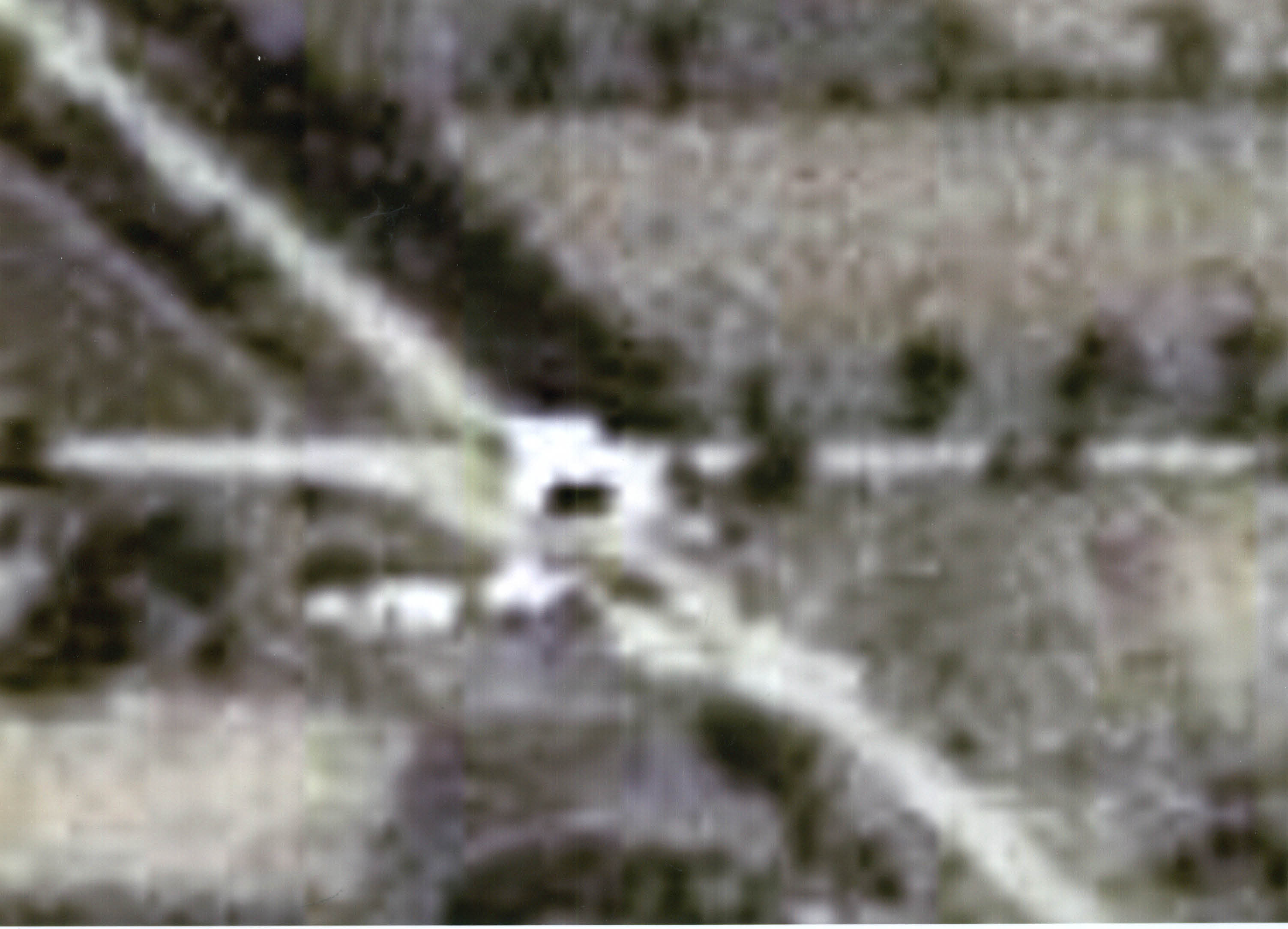
#5 Jericho Turnpike “Highway” Bridge in Mineola and a blurry Mineola Lodge
#6 Hillside Avenue Parkway Bridge in East Williston, Jericho Turnpike “Highway” Bridge in Mineola, Mineola Lodge, Westbury Avenue Parkway Bridge in Mineola/Carle Place, Mineola LIRR Motor Parkway Bridge, Old Country Road Highway Bridge.
#7 Mineola LIRR Motor Parkway Bridge and Old Country Road Motor Highway Bridge
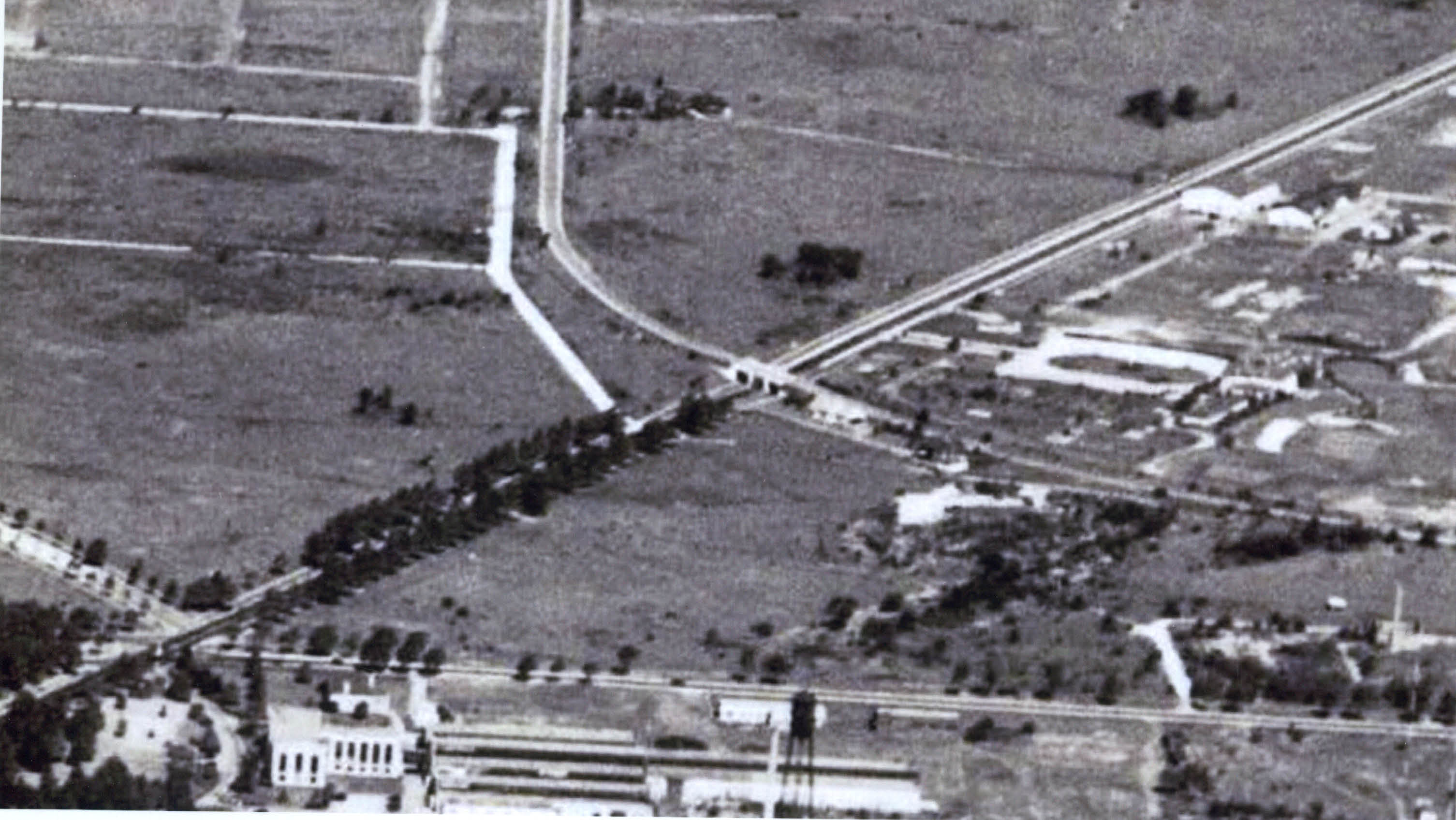
#8 The “Mayan Ruins” Motor Parkway Bridge in Garden City, Clinton Avenue Motor Parkway Bridge in Garden City, General Manager's Office and the Garden City Lodge.
#9 Hempstead Turnpike/Fulton Road parallel on the bottom
Close-Ups: Left Side (Top to Bottom)
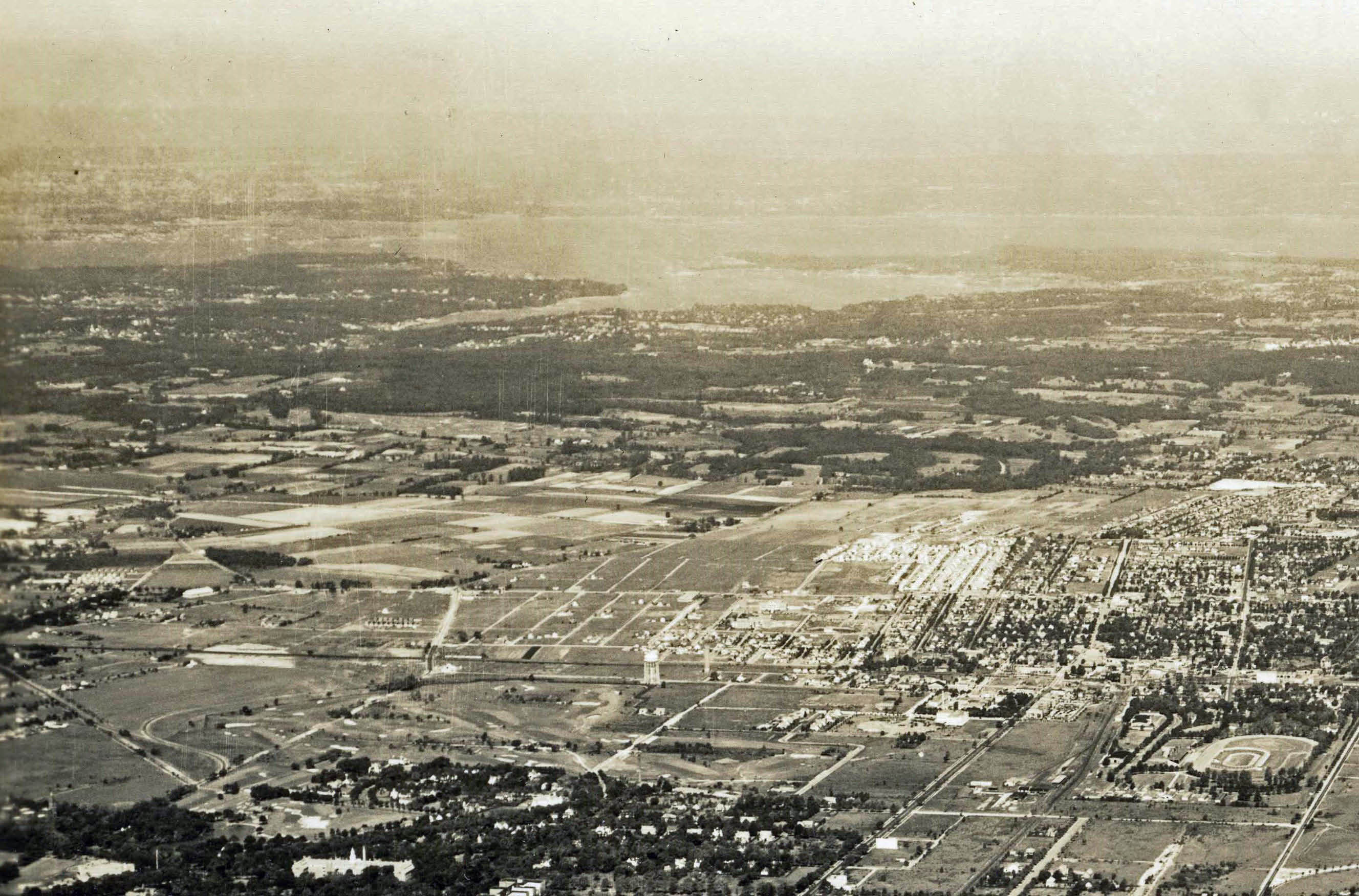
#10 Manhasset Bay on top. Garden City Hotel on the left. Mineola Fairgrounds on the right.
#11 Garden City Hotel on the bottom.

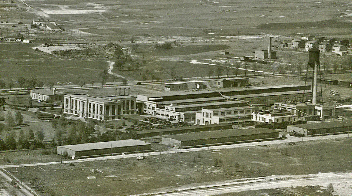
#12 The Doubleday Plant and railroad cloverleaf in Garden City.
#13 A view of Hempstead. Date and time stamp are on the bottom.
#15 Hempstead


Comments
Looking north over Garden City. At Roosevelt Field. At right in the main photo is Roosevelt Field. LIMP landmarks include the Garden City lodge, and the Old Country Rd. overpass. The Garden City Hotel and the Garden City Cathedral are visible.
Wow. Amazing Photo. Some enlargements won’t show. Looking North. Roosevelt Field to Hempstead Harbor. LIMP Bridges, Wheatley Hills Golf, Hillside Ave, Under Jericho, Over Westbury Ave, Over LIRR Mineola, Under Old Country Rd, Over Clinton, Mineola Lodge, Garden City Lodge, Managers House Garden City, Garden City Hotel, Jericho Tpke. Other Bridges that are more than likely there, Albertson LIRR, Roslyn Rd, Willis Ave. I think I will be looking at this one for a while.
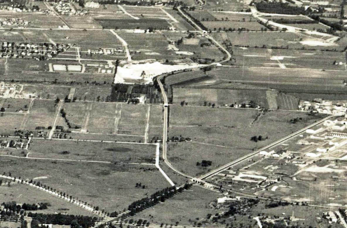
It’s Garden City, looking north. The first “close-up: left side” clearly shows Hempstead Crossing where the Central RR of LI (now LIRR Hempstead branch) crossed the line that went from Mineola to West Hempstead.
Looking north over Garden City towards Westbury and Mineola from the Hempstead village boundary. Left to right across bottom is Fulton Avenue; diagonally across to right (upward) is Westbury Blvd. running vertically is Clinton Rd. With the 3 lane Motor Parkway bridge and the toll house to the right of that bridge on the edge of Curtiss Field. Also visible is the Motor Parkway bridge over Old Country Rd. And in the distance the LIMP bridge over Jericho Tpke.
Visible also is the LIMP path through the Roosevelt Field area; the Curtiss Mfg. Plant on Stewart Ave.; the LILCO or the A&P warehouse with the water tower, as well as Commercial Ave (l t r) and the Central RR line and station just west of Clinton Rd.
Approx. year 1935.
No doubt all he aerials are the Town of Hempstead, which is the heart of the LIMP for the 1908,9 ad 10 Vanderbilt Cup Races, where it went thru Hempstead Plains. I’m not done yet, I think I’m on the roll with this one, there’s more to come tonight.
Looking North towards Hempstead bay and long island sound, garden cith takes up most of the bottom portion of the photo with the motor parkway and Mitchell field in the mid to upper right of photo. the garden city bridge as well as the old country road bridge can be seen as well as the golf course which the right of way goes through before turning west towards Roslyn. Glen cove ,Roslyn, port Washington can be seen in the upper part of the photo as well as a part of eastern queens.
This photo is looking north from a position over Hempstead and East Garden City. I believe it was taken in 1933. Some of the L.I.M.P. and V.C. R. landmarks are: Garden City Lodge and manager’s office; Clinton Road bridge; Transeverse Road (Mayan Ruins) abutments; bridges at Old Country Road, LIRR Mainline, Westbury Ave., Jericho Tpke.; Mineola Lodge; bridges at East Williston Ave., Wheatly Hills Golf Club, Roslyn Road; Roslyn Lodge; Garden City Hotel. Some other Long Island landmarks are: Roosevelt Field, Curtiss Field, Curtiss Manufacturing Plant, Long Island Sound, Hempstead Harbor, Doubleday Publishing Co., and the historic LIRR 4-way “wye” crossing just east of Franklin Ave. on the old “Central Line”.
Without cheating (looking it up), I can easily locate the pic; we’re over Hempstead, looking north at Hempstead Harbor, with Bar Beach cutting across it. You can see the Willis Avenue and Roslyn Road crossings in blowup #1 and thus where the Roslyn Lodge should appear, Roosevelt Flying Field and the pre-WWII golf course are at the right center with the LIMP coming right at us through the Wheatley Hills Golf Club, crossing over Hillside Avenue and under Jericho Turnpike, the pale Mineola DPW yard, the LIRR, Old Country Road, and crossing over Guinea Woods/Glen Cove Road and past the Super’s House and the GC Toll Lodge, angling off to our right (LI East) parallel to Stewart Avenue and its gas holder, and off image. I’ll let eagle eyes with better vision take it from here, although the LIRR Main Line at Herricks Road and the western end of Stewart Avenue in Mineola pop out at me near the bottom in the upper left #10 blowup, with Port Washington in the distance. Might that oval due north be the old Mineola Fair Grounds (although in 1950, they were north of Jericho Tpke.)? Fantastic photo; thanks, Gary and Howard! Sam, III
I liked Gary from the day I met him, with aerials like this, I like him more!
Wow! What a great shot! I’m sure I’m missing a lot with the resolution an iPad can get to, but here goes nuttin’!
-Describe the location and orientation of the aerial
Directly over Hempstead looking North/Northwest over Hemstead/North Hempstead Towns with the Great Neck, Port Washington, Glen Cove peninsulas in the distance.
-What is the date of the aerial?
Approx. 1929
-List the Long Island Motor Parkway and Vanderbilt Cup Race landmarks (a special kudo for the largest number identified)
A huge number of bridges in view; East to West;
(Old Courthouse maybe?), Shelter Rock Rd Br, IU WIllets Br, Old Searingtown Rd Br, Willis Ave Br, Oyster Bay RR Br, Roslyn Rd Br, Robbins Ln Br, Wheatley Hills Golf Br, Hillside Ave Br, Jericho Tpke Br, Westbury Ave Br, Old Country Rd Br, the ‘Mayan Ruins’, Clinton Rd Br.
Garden City Lodge, Mineola Lodge, Roslyn Lodge and the Motor Pkwy Office. There are some indiscernible ‘white blobs’ where Krugs and the Bulls Head Hotel would be!
-List other Long Island landmarks
It got interesting here…
-Many mansions and a huge amount of Phipps properties! Clearly seen is Harbor Hill and the Dairy man’s cottage/farmgroup, Westbury House, DuPont/Guest White Eagle/Templeton (Now NYIT deServersky), Spring Hill, possibly Brady’s Inisfada to the West, and too many more to list.
-Port Washington Sand Pits, Curtiss/Roosevelt Field, Curtiss Engineering, Clinton Rd train station, Garden City Hotel, St. Pauls Clock tower in GC, the diamond-shaped interchange where the GC LIMP lodge currently sits, more golf courses than one can shake a stick at- Garden City Golf Club, Links Golf Course, Wheatley Hills Golf Course, etc
I’m missing a lot, but I could spend many more days on this one!
Describe the location and orientation of the aerial
Garden City, mid-Nassau County looking north. Clinton Road and Old Country Road, among others. Motor Parkway running north and south in the middle of the picture
-What is the date of the aerial? - 1927
-List the Long Island Motor Parkway and Vanderbilt Cup Race landmarks (a special kudo for the largest number identified)
Clinton Road Bridge
Mayan Ruins – the never to be built bridge
Old Country Road Bridge
LIRR Motor Parkway Bridge
Westbury Avenue Bridge
Jericho Turnpike Bridge
Hillside Avenue Bridge
Garden City Hotel - served as the headquarters for the Vanderbilt Cup Races (1903-1910)
Roosevelt Raceway – site of the 1936 and 1937 Vanderbilt Cup Races
Garden City Lodge
Motor Parkway Office (Garden City)
Wheatley Hills Golf Club (Motor Parkway running through it)
Mineola Lodge
-List other Long Island landmarks
Curtis Field, Curtis Aeroplane & Motor Corporation, Curtis Engineering Corp., St. Mary’s Cathedral, Garden City Golf Club, Queens County Fair Grounds, St. Paul’s Cathedral, Garden City Golf Club, Clinton Road Railroad Station, Central RR Tracks, Country Life Press Station, Doubleday Factory, Intercollegiate Golf Club, Aviation Field
I guess I’m not on the roll with this one. The only thing that I think I found is the Newbridge Road Bridge. I remember seeing things, but can’t place then, the roads, buildings, where they are, like that tank in photo #1&2 and I’m not sure of myself. Well, I tried anyway
I guess I’m not on the roll with this one. The only thing that I think I found is the Newbridge Road Bridge. I remember seeing things, t I can’t place them, the roads, buildings where they are, like the tank in photo #1&2 and I’m not sure of myself. I tried anyway
1933 super wide aerial of Hempstead looking north towards Manhasset Bay, Roslyn Harbor (future home of the Black Beast), and more! Difficult to see without the zoomed images. LIMP traveling through Willis Ave bridge, LIRR bridge, Roslyn Lodge, Roslyn Rd bridge, Wheatley Hills golf, Hillside Ave bridge, Jericho tpke hwy bridge, Mineola Lodge, Westbury Av bridge, LIRR bridge again?, Old Country Rd bridge, Mayan Ruins, Clinton Ave bridge, Manager’s House, Garden City lodge, former Roosevelt airfield, too much I give up.
Fantastic picture (date says 3.10.30) looking north from Hempstead Village to what seems Hempstead Harbor on the north shore. Motor Parkway curve around Roosevelt Field, with Office and Toll Booth, looking north is Old Country Road bridge, LIRR Bridge, Westbury Ave Bridge, I U Willets Road Bridge, and the golf course before the parkway turns west. Other cool things are the Garden City Gas Tank, The Winthrop Hospital Smoke Stack in Mineola, all the hangars of Curtiss
Field, as well as the Curtiss Factory. So much in one picture i’m still looking !!
It is really a beautiful photo and the amount of detail is enormous. I have no idea of the date and I will not go for the largest number of landmarks, but just for the general view. The picture is taken above Hempstead, in northward direction towards Roslyn/Hempstead Harbor. Somewhere in the middle of the photograph Jericho Turnpike runs from left to right. The area above that road was the western part of the 1905 and 1906 VC course. It could be that the road with S-bend and bridge somewhat right to the middle of the photo is the first part of the LI Motor Parkway. In the middle on the left between the trees you can see the Garden City Hotel.
just wondering what big white building is northwest of Garden City hotel. could it be the old Queens county courthouse?
Truly fantastic aerial! Thank you Gary and Howard for presenting this. This will take some summertime fun to sort out. Goodtimes ahead——>
My compliments to Gary Hammond. Can he please tell us where he gets his eyes checked as I would like to be able to see half of what he was able to in this photo.
Nice job !