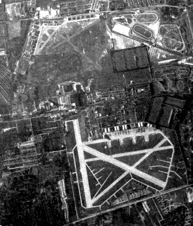
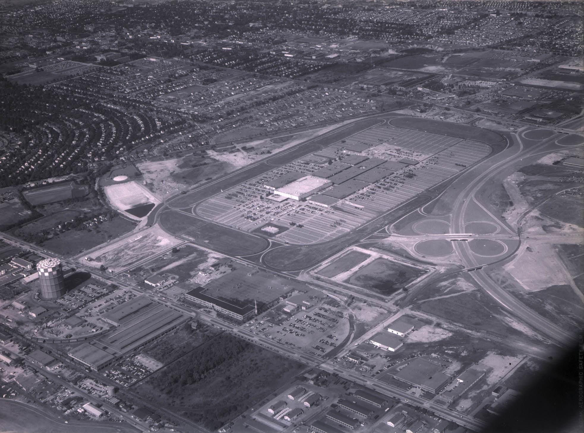
Mystery Foto #82 Solved: Aerial View of Mitchel Field and Roosevelt Field on September 1, 1948
Frank Feminas challenged you to solve another Mystery Foto.
Mystery Foto questions:
-Identify the location of the aerial and key roads and structures.
Structures: Mitchel Field and Roosevelt Field airports and Roosevelt Raceway (harness racing).
Roads: Old Country Road (top), Hempstead Turnpike (bottom), and Clinton Road (left)
-What is the approximate date of the aerial? Why?
This aerial was taken by the United States Geological Survey (USGS) on September 1, 1948.
-How is the aerial related to the Long Island Motor Parkway, the Vanderbilt Cup Races and aviation history?
Remnants of the Long Island Motor Parkway can still be seen in the aerial after it crossed Clinton Road.
The 1904 Vanderbilt Cup Race course included this section of the Hempstead Turnpike.
Mitchel Field and Roosevelt Field are packed with aviation history.
Congrats to Andy Hartwell, Greg O., Michael LaBarbera, Joe Oseterle, Ernie M., Tim Ivers, Joel Friedman, Steve Lucas , Michael Appice, Art Kleiner, Richard Krause and Karen Codrado for identifying the two historic airports. Kudos to Greg O., Michael LaBarbera, Ernie M. , Tim Ivers, Joel Friedman, Steve Lucas, Michael Appice, Art Kleiner and Karen Cordaro for all the details described in their below comments.
Thanks Frank for the Mystery Foto submission and documentation.
Please submit any suggested Mystery Fotos to me at [email protected].
Enjoy,
Howard Kroplick
Documentation submitted by Frank Feminas
Then & Now
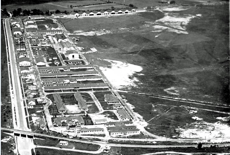
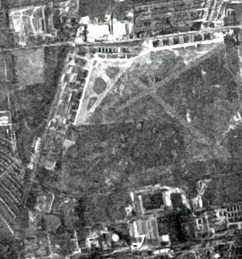
The Long Island Motor Parkway's General Manager Office and the Garden City Lodge can be seen in the lower left corner. Source: Abandoned & Little Known Airfields: New York, Long Island Nassau County
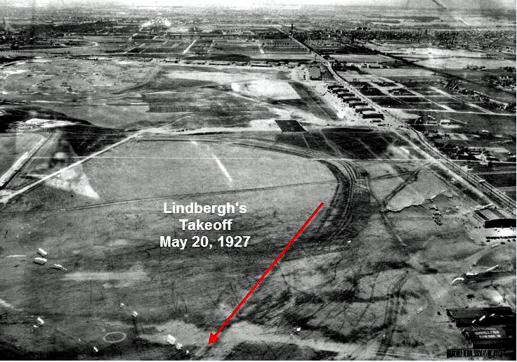
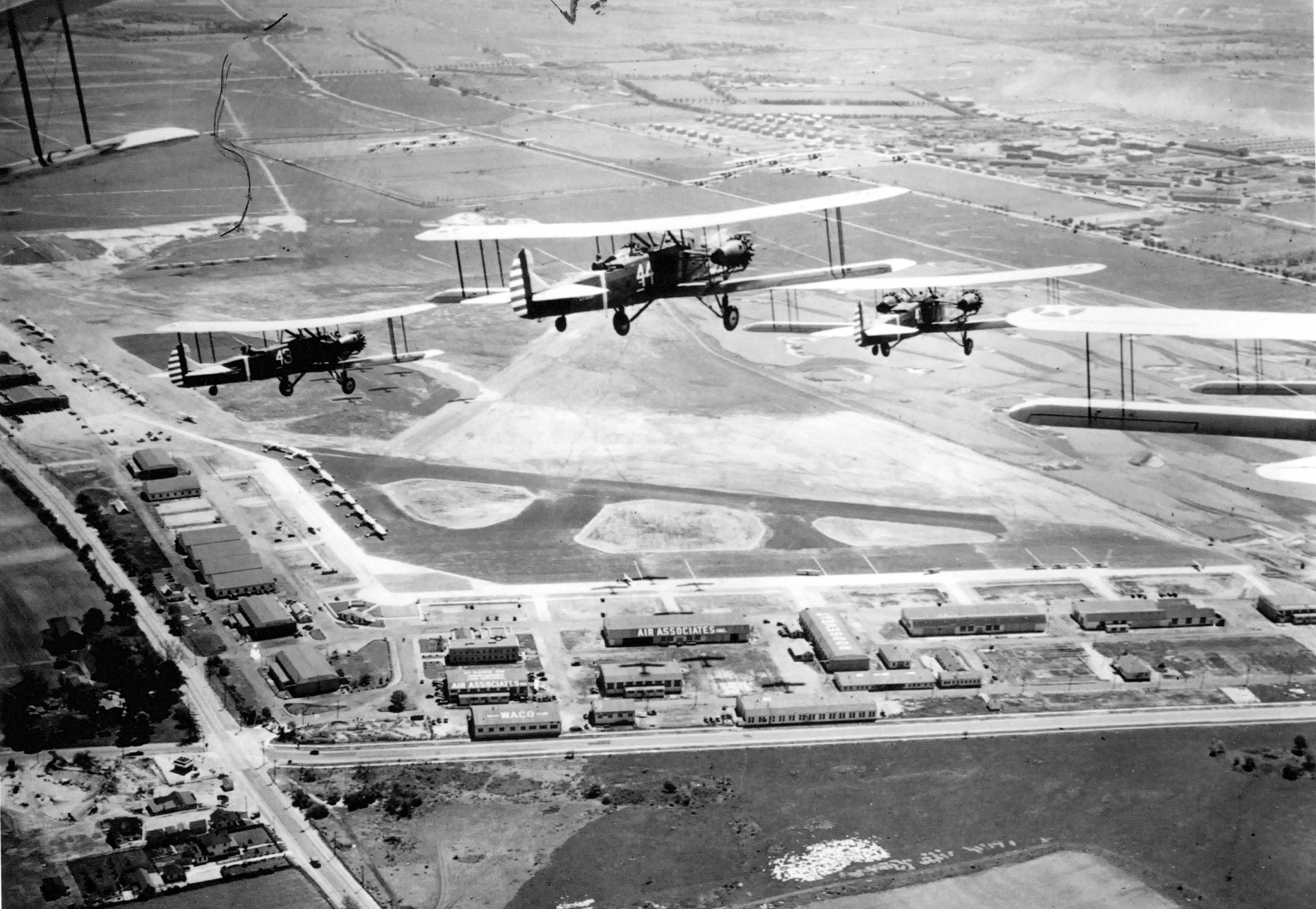
Early 1930s looking west at Lindbergh's takeoff. Source: Abandoned & Little Known Airfields: New York, Long Island Nassau County
Other Aerial Views of Roosevelt Field and Mitchel Field
1931

August 10, 1938
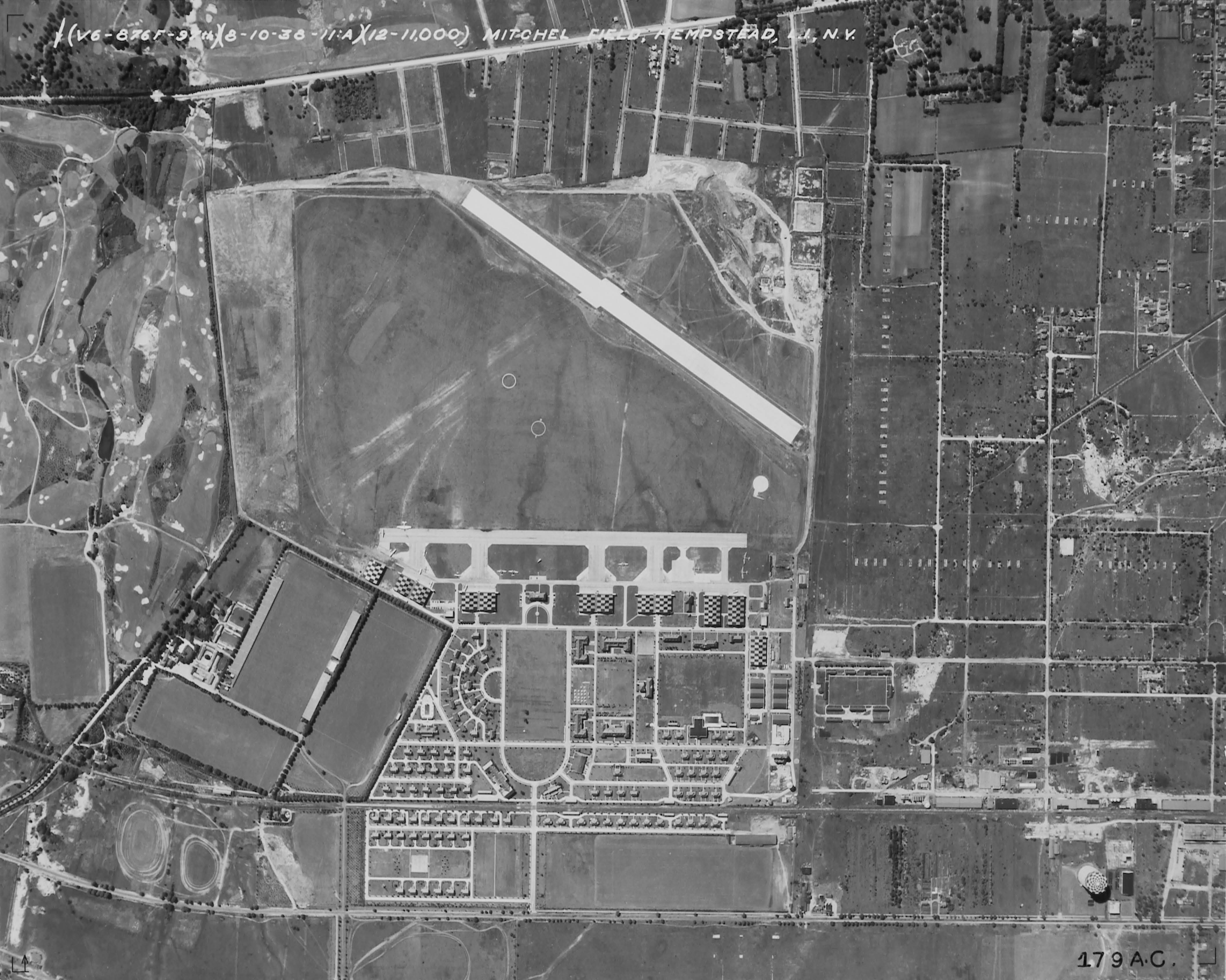
August 10, 1938
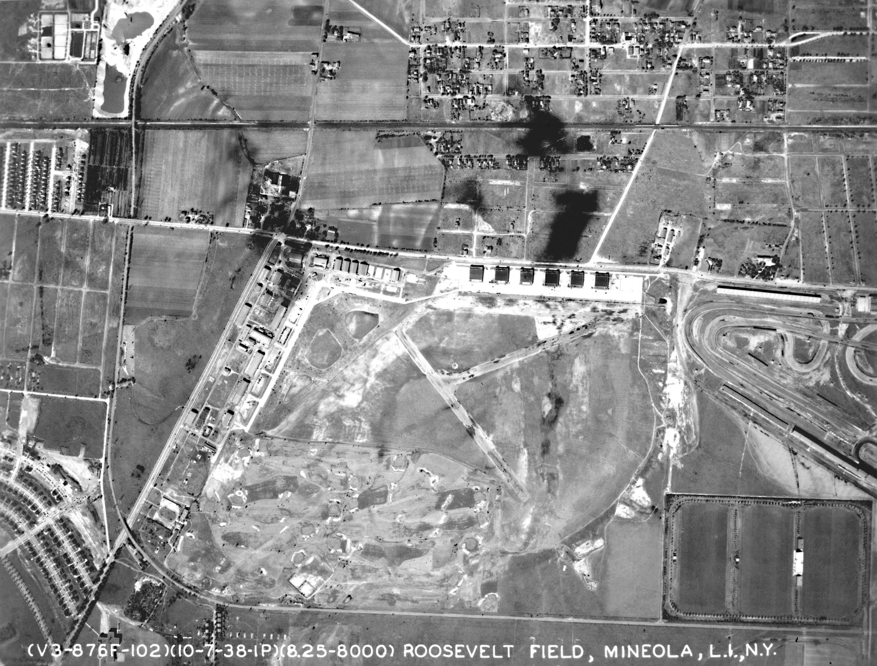
October 7, 1938
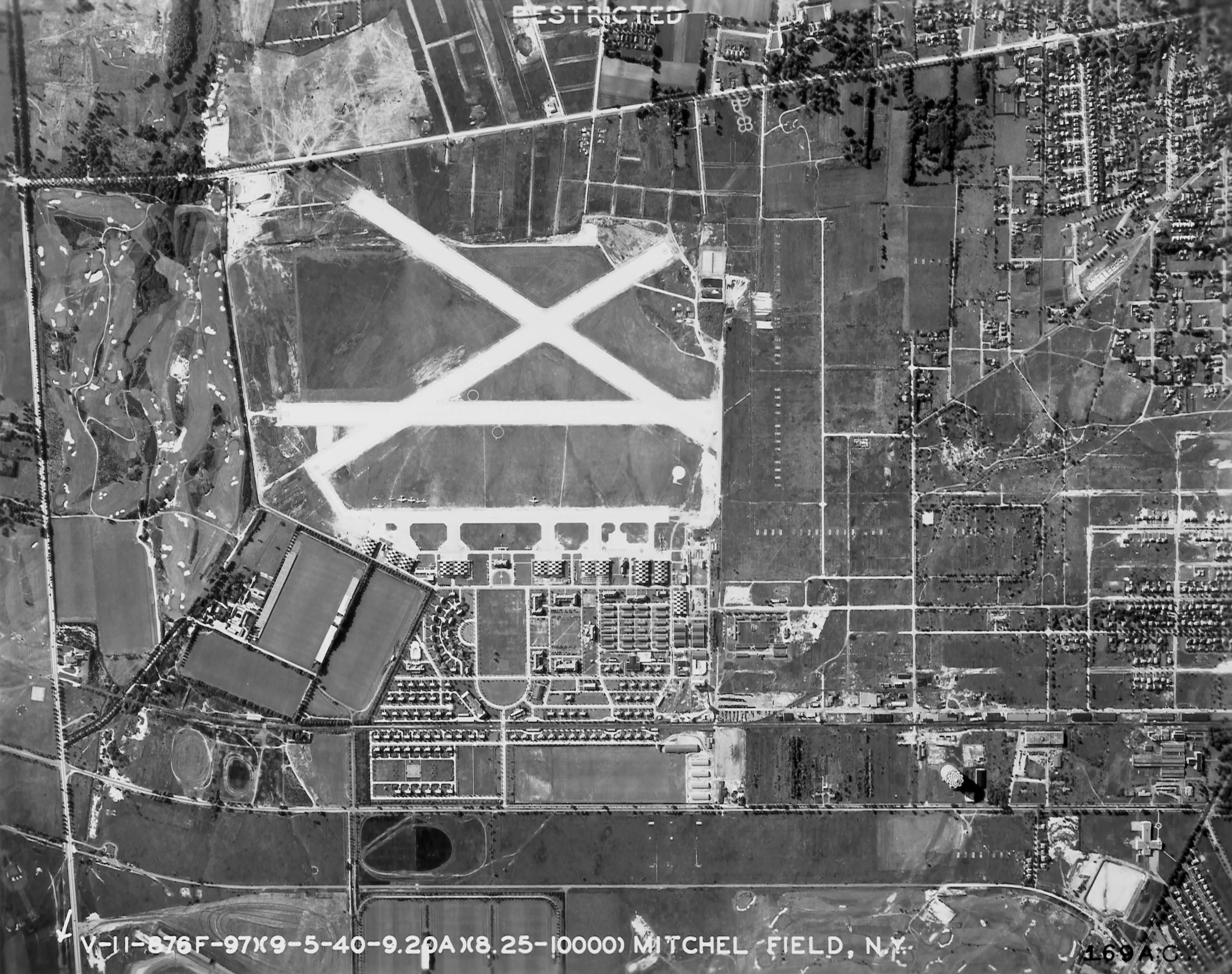
September 5, 1940
October 3, 1956
Closeups


Comments
Mitchell Field / Roosevelt Raceway / Early 1900’ /30s?
-Identify the location of the aeriral and key roads and structures.
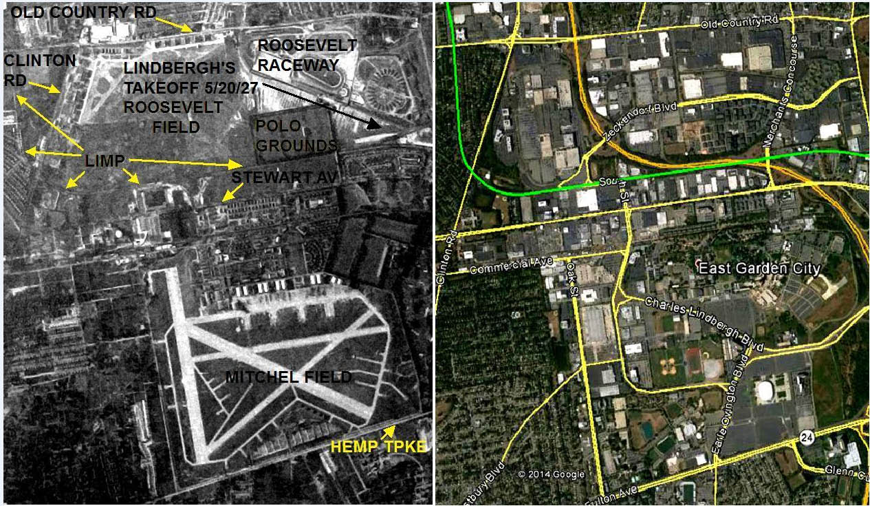
Over Roosevelt Field, Roosevelt Raceway and Mitchell Field. Old Country Road across the top, Stewart Ave next to the closed LIMP in the center, and Hempstead Tpke at the bottom.
-What is the approximate date of the aerial? Why?
September 1, 1948
Roosevelt Raceway harness track opened in 1940 and the Meadowbrook Parkway construction didn’t start until 1953. I also identified the aerial and the exact date on one of my aerial database websites that I frequently visit.
-How is the aerial related to the Long Island Motor Parkway, the Vanderbilt Cup Races and aviation history?
The LIMP travels through the center of the photo, and there are portions of a few Cup race courses. There’s plenty of history within the few airfields, but most noteable would be Lindbergh’s 1927 Trans-Atlantic takeoff from Hazelhurst Field where Roosevelt race way is standing in the photo.
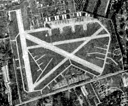
Upper Left Roosevelt Field, Upper Right Roosevelt Raceway, Lower Left Hempstead (Hofstra and 1st Presby Church and Cemetery), Lower Right Santini Hospital (or kellenberg depending on the year). Mitchel Field in the center around or just after WWII days. Above that we can still see the Meadowbrook Hunt Club, the Polo Fields and and the Raceway Paddock. Motor Parkway has given way to shrubs and houses but it looks like parts remain on the right hand side of the picture. The Meadowbrook State Parkway is not yet built so it looks pre 1955, but cannot be earlier than 1940 since Garden City houses are going up where the Motor Parkway turned. Roosevelt Field shopping Mall not yet built but the airfield looks closed. I would guess this picture is postwar maybe in a 5 year period between 1947 to 1952. I discovered that If you go north of the Marriott Hotel and make a right onto Charles Lindbergh Blvd you can still see part of the original taxiway on the southeast part of Mitchel Field behind the fence. Definitely pre-jet era also because runway 23 is not fully developed.
Roosevelt Field, Mitchell Field, and all that goes along with it.
-joe
-Identify the location of the aeriral and key roads and structures.
For roads,along the top left to right is Old Country Road. Bottom right to center is Hempstead Turnpike. Stewart Ave cuts thru the center, paralleled by the old Stewart Central Railroad line. Clinton Road runs the west (left) side of the airfield.
Prominently in the lower center we have the Mitchel Air Force Base. Top left is Roosevelt Field Airport, not the shopping mall. Top right is Roosevelt Raceway in the revised horse racing, not the original motor speedway configuration.
Beginning at the top left corner running south (down) is the Long Island Motor parkway. It curves across Clinton till it runs along the south side of the airport and the raceway.
What is missing is the Meadowbrook parkway, which today meanders thru this scene, even eating up some of the LIMP right of way.
-What is the approximate date of the aerial? Why?
Two bookend dates: Roosevelt Raceway opened as a horse track in 1940. Construction on this portion of the Meadowbrook began in 1953. I could not narrow it down any closer.
-How is the aerial related to the Long Island Motor Parkway, the Vanderbilt Cup Races and aviation history?
How is it not? The Motor Parkway itself runs all thru the image.
Roosevelt Raceway was the site of the 1936 and 37 Vanderbilt Cup Races when it was still a motor speedway.
Roosevelt Field Airport is where Lindbergh left for France, also the 1920 Pulitzer Trophy Race. Mitchel Field held the 1925 Pulitzer Trophy Race.
Looking north across Mitchel Field about 1948.
Left to right across bottom Fulton Avenue (Hempstead Turnpike).
Old Country Road left to right across top.
Roosevelt Field in upper left ( forming a right angle)
Stewart Avenue running left to right across center at north edge of Mitchel.
Long Island Motor Parkway left to right just above Stewart Avenue
Roosevelt Raceway at top right
Clinton Road bridge over LIMP at lower left
Rectangle abutting LIMP at center right is Meadowbrook Polo Field
Meadowbrook Country Club is square boxed area at center right
Old Westbury Golf Club center left under Roosevelt Field above LIMP
LILCO gas tanks on Stewart Ave, center left
Roosevelt field and raceway
The picture is taken north to south. Roosevelt Field on the top, Roosevelt Raceway next to it, and most prominently, Mitchel Field on the bottom. Mitchel Field has the added runways and dispersal points constructed during World War II. Hempstead Tpke.is at the bottom. Stewart Ave. is the road separating Roosevelt from Mitchel. The Motor Parkway which really can’t be seen was south west and south Roosevelt Field and parallel to Stewart Ave. and was gone by the time this picture was taken after WWII in the late 1940’s The Vanderbilt Cup Race was held at Roosevelt Raceway made from half of Roosevelt Field in 1936 & 1937. To the east of Mitchel Field are the Polo Fields and golf course of the Meadowbrook Club
could this be the old Flushing airport…located partially in College point and flushing.
that is now well defunct ???
could this be the old Flushing airport…located partially in College point and flushing.
that is now well defunct ??? Off of the now parkway that goes to the throgsneck bridge. ??
I predict you’ll be listing a lot of names who get this one right, as nearly everyone who’s a fan of your site would recognize the Motor Parkway running east/west between the remnants of Roosevelt Field (above) and still-active Marshall Air Force Field (below). Circa late 1940s. Where the parkway turns north is of course Clinton Street, and Meadow Brook Polo Field is the prominent dark rectangle that abuts the parkway further to the east.
Looks like the plane from which this photo was taken was directly over Mitchel Field in the Hempsted / Uniondale area with the camera pointed in a northerly direction. There’s Roosevelt Field (the airfield, not the mall) in the upper left with Roosevelt Raceway (horses, not cars) to the right of that; former site of the 1936 & 1937 Vanderbilt Cup Races and formerly Hazelhurst Field, where Lindbergh took off in 1927. Technically, the 1908, 1909, & 1910 V. C. Races went through a portion of the upper right corner also (Ellison Ave.). Remnants of the L. I. Motor Parkway are also visable entering the photo at the upper left corner, proceeding south, and then east near the middle. Major east-west roads are Old Country Road near the top, Stewart Avenue (center) and Hempstead Tpke. near the bottom. A small piece of Merrick Ave. can be seen at the upper right corner. It appears that there is early constuction for the Meadowbrook Parkway extension (Old Country Rd bridge) so I’m going to date the photo around early 1954.
The aerial shot is of Roosevelt Field, Mitchell Field, and Roosevelt Raceway bordered by Old Country Rd. at the top of the foto Glen Cove on left of the foto, Hempstead Trpk. at the bottom of the foto and Motor parkway in the middle of the foto above Mitchell Field. I think its around 1951 because Roosevelt Field looks abandon. The aerial is important because it shows the major airfields a horse racing track and parts of the Motor parkway that you can see in the foto all of which have dissappeared.
-Identify the location of the aerial and key roads and structures. Hempstead, Garden City. Hempstead Turnpike on the bottom, Oak Street on the left, Clinton Road on the left running midway down, Motor Parkway next to Clinton then crossing it and going across the picture. Old Country Road at the top of the pic. Stewart Avenue. Hangers and runways of Mitchell Field and Roosevelt Field. Hofstra College building south of Hempstead Turnpike, Meadowbrook Polo Field, Meadowbrook Country Club, Motor Parkway Garden City Lodge.
-What is the approximate date of the aerial? Why?
Sept. 1, 1948. Actual photo found on the internet with date attached. Also, houses in Stewart Park (area bounded by Clinton Road, Motor Parkway and Old Country Road) not built until mid-1950. Probably more clues, but not enough brainpower to go on.
-How is the aerial related to the Long Island Motor Parkway, the Vanderbilt Cup Races and aviation history? Route for the Vanderbilt Cup Races somewhere in picture, Garden City lodge erected just east of Clinton Road, Charles Lindbergh, not the right person at the wrong time. Charles Lindbergh left on his final triop from inside.
Hmmm that appears to be Mitchell field on the bottom, and Roosevelt field at the top…..I also believe the roadway on the south side of Mitchell field is a very early Hempstead tpke! I suspect this is prior to or just before WW2 The field seems to be not stocked with aircraft ( Mitchell field?) Anyway that is my guess!
Howard, I think that in the upper portion of this photo, I can see the Vanderbilt Parkway. I believe that below that is Roosevelt Raceway and then Mitchell Field south of that. Hempstead Turnpike is running east/west below the field. I think this photo shows the hangars at Mitchell Field where Nassau Community College now stands. Not sure of the date, but way before the college was built in 1959.