Mystery Sunday Foto #25 Solved: A 1954 Aerial View of “Salisbury Park” in East Meadow
Author Richard Panchyk challenged you to solve this weekend's Motor Parkway aerial.
Mystery Foto questions:
- Identify the location of the remnants for the Motor Parkway.
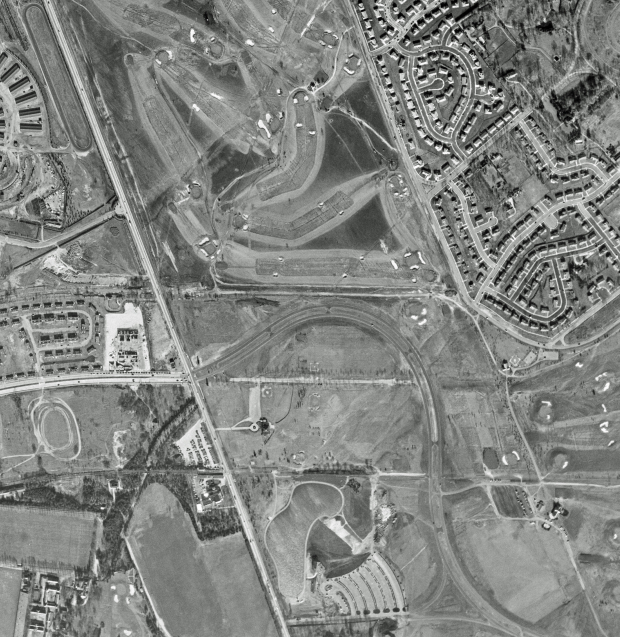
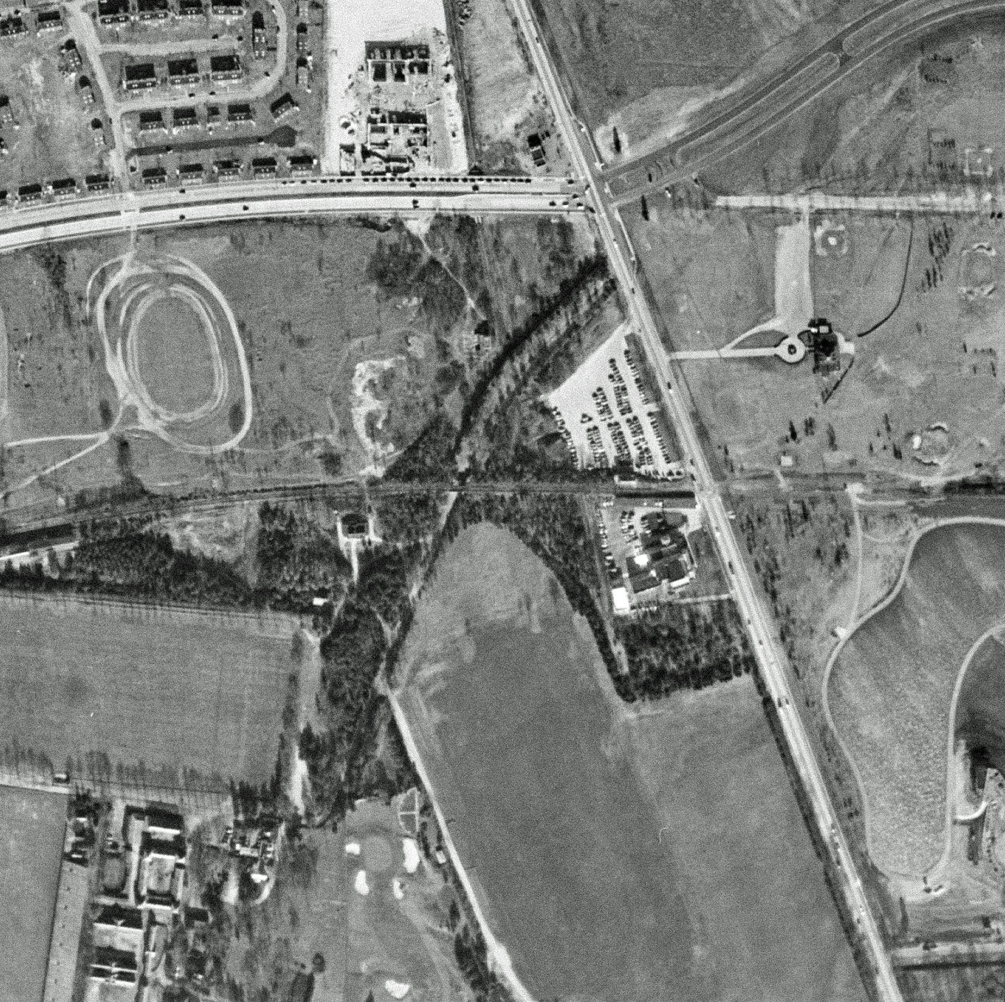
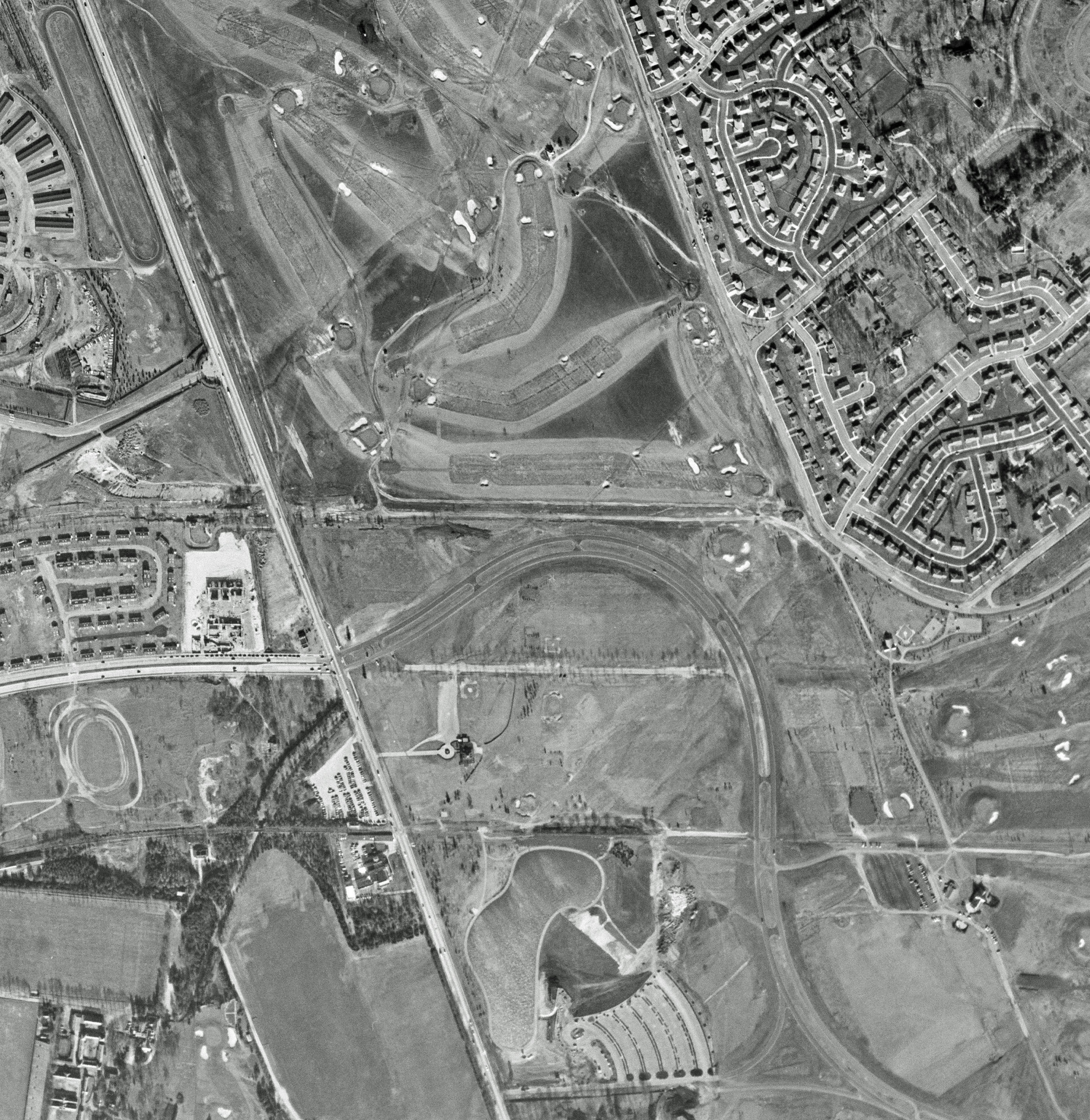
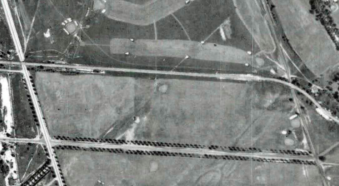
The aerial was photographed over the now current Eisenhower Park in East Meadow. Remnants of the Motor Parkway can be seen in the middle of the aerial.
- Identify a Motor Parkway structure in the aerial.
The Meadow Brook Lodge can be seen still standing in the "keyhole" entrance west of Merrick Avenue. The Merrick Avenue Motor Parkway Bridge has been taken down in the 1940s.
- What was the area in the center of the aerial called when Motor Parkway was active, when the photo was taken and what it is called today?
When the Motor Parkway was active: Salisbury Links and Salisbury Country Club
When the photo was taken: Nassau County Parky at Salisbury. East Meadow residents just called it "Salisbury Park".
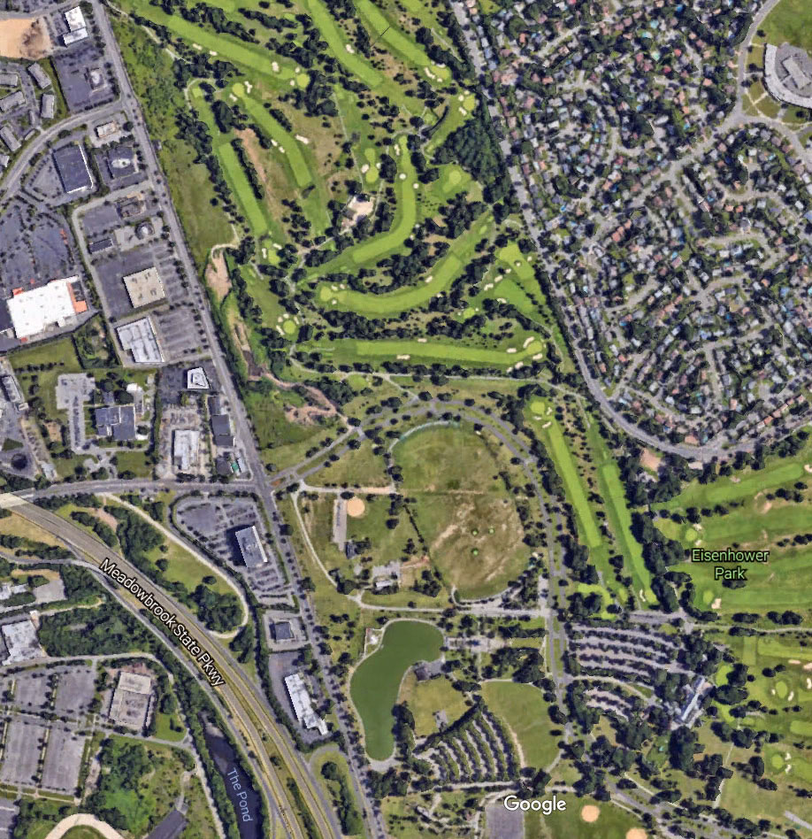
What it is called today: Eisenhower Park
- What other transportation byways were defunct in this aerial?
Directly below the Motor Parkway, Stewart Avenue used to run straight across the park. The array of trees, which I remember as a child, can be seen in the aerial.
The extension of Newbridge Road from the Motor Parkway (now East Meadow Avenue further south) has been broken up.
Below Stewart Avenue and above the lake, the defunct right-of-way of the Central Branch of the LIRR still can be seen.
- What is the approximate date of this photograph? Provide a rationale.
Richard Panchyk dates the Mystery Foto as 1954 based on the Stewart Avenue loop, the housing developments and the remnants of the Motor Parkway and Meadow Brook Lodge.
Comments (12)
Congrats to Lee Chambers, George Philippides, Paul Rum, Al Velocci, Steve Lucas, Art Kleiner, Marc Alssid, Joe Oesterle, Frank Mendyk, Greg O., and Tim Ivers for identifying my childhood hometown village of East Meadow.
Kudos to Lee Chambers, Paul Rum, Al Velocci (my favorite co-author), Steve Lucas, Art Kleiner, Joe Oesterle, Frank Mendyk, Greg O. and Tim Ivers for identifying the still standing Meadow Brook Lodge.
Enjoy,
Howard Kroplick
Close-Ups
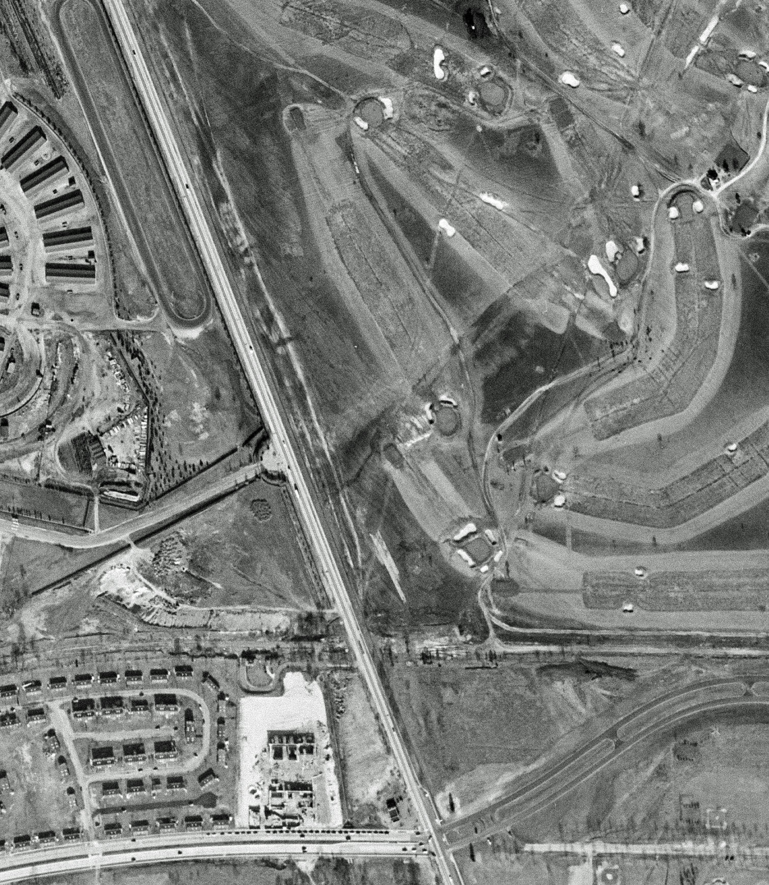
Note the Meadow Brook Lodge still standing within the "keyhole" entrance.
Now-Google Earth Aerial
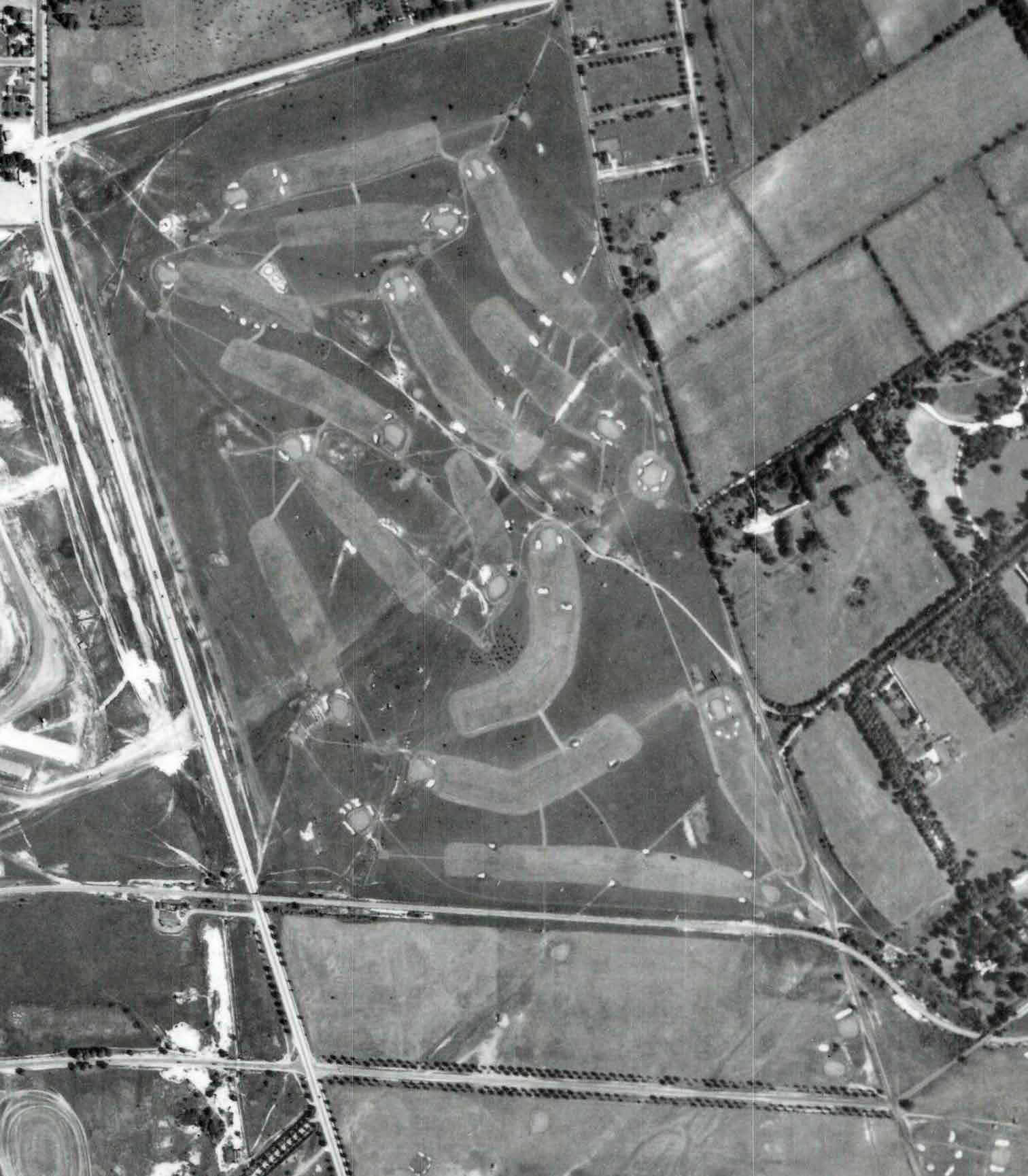
1938 aerial of East Meadow showing the Motor Parkway and Stewart Avenue.
The Stewart Avenue of trees and the Motor Parkway bridge over Newbridge Road.


Comments
Most of the center of the photo was the Salisbury Golf Club, later Salisbury / Eisenhower Park.
Remnants of the original alignment of the LIMP, Stewart Avenue and the Central RR of LI are visible as they cross Merrick Ave. through the park. Also seen are the Salisbury Plains RR station as well as the Meadowbrook Club.
Just north of Stewart Ave. and to the west of Merrick ave. was the entrance and toll booth to the LIMP.
Immediately to the north of Stewart Ave. is Mitchel Manor, site of the recycling plant today.
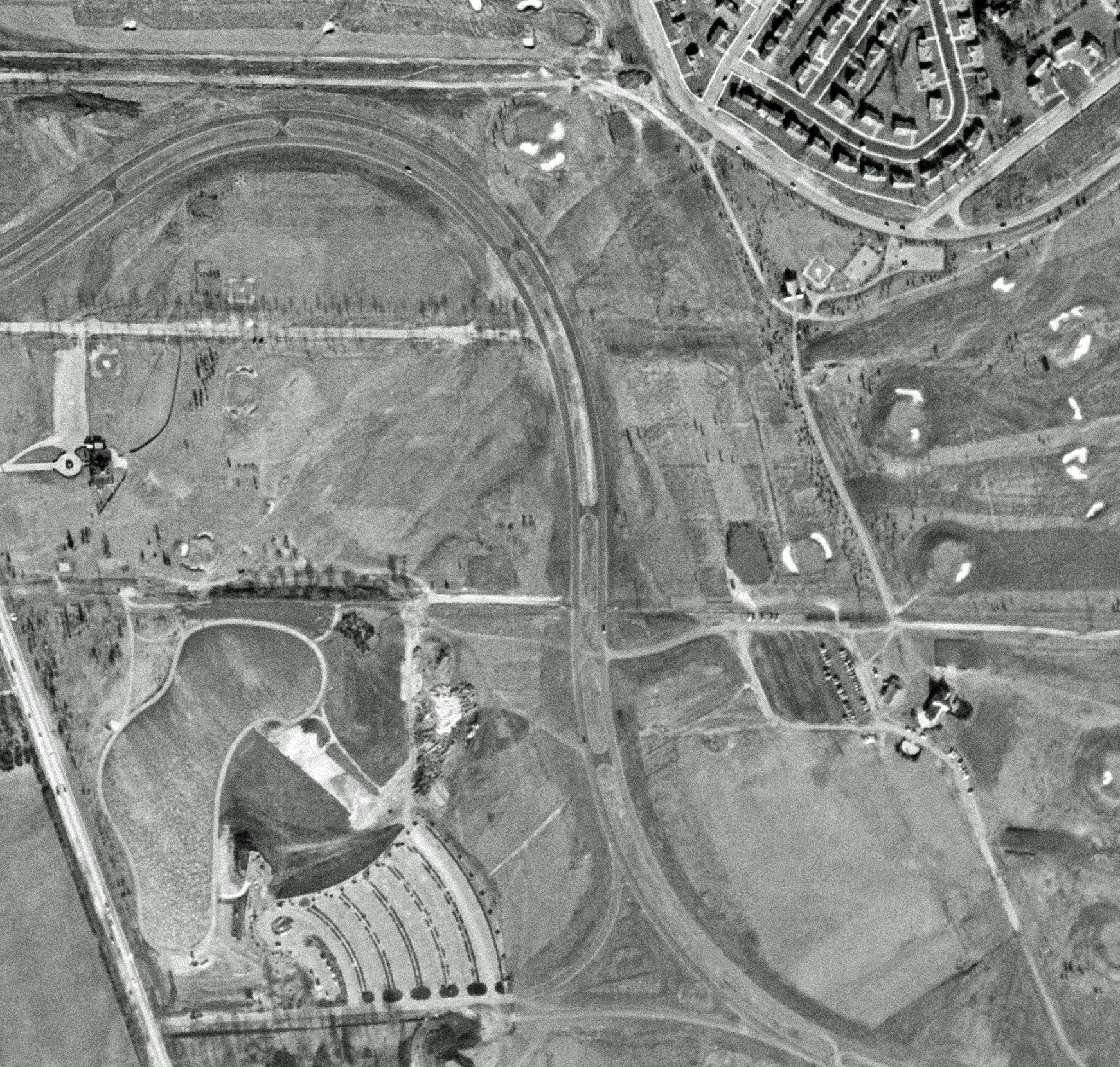
In the top left of the main photo are the stables for Roosevelt Raceway.
At the bottom left of the main photo are the surviving grandstands and support buildings for the Polo Grounds, immediately adjacent to the USAF property at Mitchel Field.
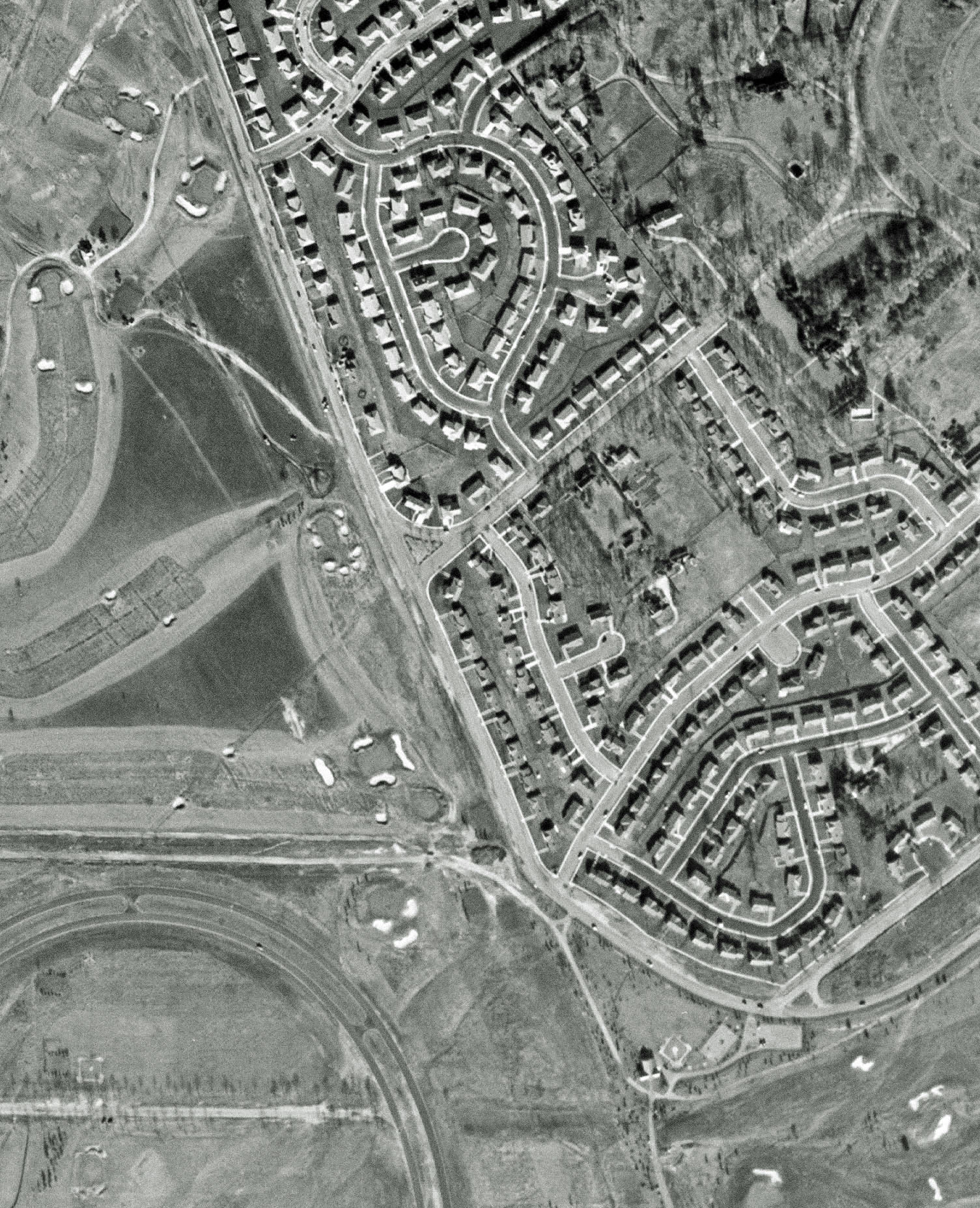
Top right on the main photo are the homes in the Salisbury section of East Meadow.
The man-made lake at the park can be seen across Merrick Ave. from the greens at the Meadowbrook Club.
The home lived in by Alexander Stewart’s sister now used by Nassau County Parks is just to the north of the lake.
Post WWII, probably early-mid ‘50’s judging by the sweeping roadway through the park present after the County decided to make it a public park.
LIMP is running east-west, crossing Merrick Avenue in East Meadow, just south of the golf course. The Meadowbrook lodge is visible just west of Merrick Avenue.
I am not certain if the merrick Avenue bridge is still there.
The area in the center, with the golf course, was Salisbury Country club, then Salisbury Park in the 1940s then renamed Eisenhower Park in 1969.
I believe a now defunct transporation by way was the Central LIRR line to the south, running east-west.
I don’t think I see the Merrick ave bridge so I will guess the picture was taken in 1940s
Eisenhower Park is the location.
The roadway and remnants of it still visible through the park and West of Merrick Ave, along with the Meadowbrook entrance spur and the Meadowbrook Lodge.
The park was originally called Nassau County Park, and the course was operated by the Salisbury Golf Club. It’s name changed to Eisenhower Park in 1969.
There are 3 other roadways I see that are also defunct, along with their surroundings mostly changed since then. They are all to the West of Merrick Avenue in this photo.
The photo was taken sometime between the mid 1940’s and mid 1950’s. This conclusion is reached by noting that the Merrick Ave bridge was torn down in the early 1940’s, and the lodge was torn down before 1955. As the photo shows, the lodge is still there, but the bridge is not.
Parkway remains, from left to right. a small section west of Merrick Ave. with the entrance to the Meadowbrook lodge and the lodge itself clearly visible. On the east side of Merrick Ave. a short section of the Parkway is missing. The Parkway starts up again at just below the tee box of the 17th hole of the Red course running to the green near today’s Salisbury Park Dr. The Parkway can be seen once more in the bed of today’s Salisbury Park Dr. which the County opened in 1955. At the time the Parkway was built the area was known as the Sailsbury Plains or simply Salisbury.; today it is part of East Meadow. Roadways that have disappeared since the photo was taken include that section of Stewart Ave. between Merrick Ave. and Salisbury Park Dr. Also gone is the LIRR r.o.w between Endo Blvd. in Garden City East and Carmen Ave. in East Meadow, The tracks were taken up in 1952. The LIRR r.o.w. is still identifiable by the transmission lines that separate the white and blue golf courses of the Park. Also missing is the road the Motor Parkway went over before going under Stewart Avenue, Newbridge Ave. At one time it ran southward from Old Country Rd. thru the center of the Park from Salisbury Park Dr. to Hempstead Tpke. The Hempstead Tpke. entrance to the Park is in the bed of Newbridge Ave. The north-south portion of Salisbury Park Dr. was previously Newbridge Ave. I date the photo around 1958, there is traffic on Salisbury Park Dr. but the clubhouse complex in the Park has not been built yet.
Looks like we’re in East Meadow directly over the soon to be completed Salisbury County Park with north at the top of the photo. There appear to be remnants of the LIMP running east - west on both sides of Merrick Avenue with the Meadow Brook lodge still visible. When the LIMP was active, the park was known as the Salisbury Links or Salisbury Country Club. Today we know it as Eisenhower Park. Some defunct byways include the portion of Stewart Avenue now included in the park grounds, the former Central Branch of the LIRR, the section of the LIMP that was combined with Newbridge Avenue to form Salisbury Park Drive, and the southern portion of Newbridge Avenue (north of Hempstead Tpke.) that was enclosed within the park. Since it appears that the park is almost completed and it opened in 1949, I’m going with that as a date.
Eisenhower Park, area was the Salisbury Links back in the Motor Parkway days.
Merrick Avenue Toll lodge shown.
Central RR other transportation mode.
mid-1950s - homes along Salisbury Park Drives were built 1953. 1954.
Photo is of what is known today as Eisenhower Park and previously Salisbury Park. In the middle of the picture on the left or West would be Stewart Avenue. On the top left of the picture you can see the practice track and stables for Roosevelt Raceway. These were next to Merrick Avenue which runs North/South. The top right of the picture shows Salisbury Park Drive in Westbury and the golf course. On the bottom center of the photo, you can also see the lake where the Harry Chapin Lakeside Theatre is today.
We are looking at the former Meadowbrook Club, now the property of Nassau County’s Eisenhower Park. The Motor Parkway enters from the left, where we can see the keyhole entrance at the Meadowbrook Lodge. It appears that the building no longer stands. The picture is approximately 1960.
The photo is looking over East Meadow and the old Salisbury Park or the present Eisenhower Park.
LIMP - the sections of the parkway that can be seen are, #1) the section inside the park between the Red course and the north side of Park Blvd. #2) the section by the Mitchel Gardens housing development and the Meadowbrook Lodge. There appears to be also a small section south of Salisbury Park Drive.
The LIMP structure would be the Meadowbrook Lodge.
The area in the middle of the aerial would be the old Salisbury Links golf course which became Salisbury Park and then Eisenhower Park in 1969.
The LIRR Central Branch/Stewart RR can be seen running across the photo. Also seen is the old Meadowbrook/Salisbury Plains station and the railroad bridge over the old Meadowbrook(brook or stream). The bridge stills exists and is between the exit/ entrance ramps and the Meadowbrook parkway just west of the old Meadowbrook station.
The date of the photo would be in 1954. Some houses west of the park shown in the photo were built in1954. There were no signs of construction of the new Meadowbrook parkway in the photo. The photo of the area taken on 1/28/55 shows the construction of the parkway just beginning.
-Identify the location of the remnants f or the Motor Parkway.
The top byway of the 3 that originally ran through Eisenhower Park area.
-Identify a Motor Parkway structure in the aerial.
Meadow Brook Lodge
-What was the area in the center of the aerial called when Motor Parkway was active, when the photo was taken and what it is called today?
Salisbury CC Golf courses, Now, Eisenhower Park
-What other transportation byways were defunct in this aerial?
Central RR line
-What is the approximate date of this photograph? Provide a rationale
1955
At the time this photo was taken the park was named Nassau County Park at Salisbury.
Diagonally from top left to bottom center—Merrick Avenue
Salisbury Link Golf at top center to the right of Merrick Avenue
3 “pathways” running horizontally and fairly parallel across middle, the top one being the right of way of the LIMP, wheich then curves on the right becoming Salisbury Park Drive
The LIMP bridge over Merrick Avenue appears to be gone, but the keyhole shaped driveway to the left of Merrick Avenue which was the Parkway entrance seems to be there.
The middle of the pathways looks like Stewart Avenue
The bottom one looks like the LIRR right of way which curves snakelike east of Merrick Avenue
The Meadowbrook Club polo field and Coldstream Golf Club is at lower left
The area in center used to be called Salisbury Park. Today it’s Eisenhower Park.
My guess on the date is 1955.