Sam & Dave’s Excellent Lost Motor Parkway Adventure III: The “Mayan Ruins” in Garden City

On Saturday, March 12, 2016, Dave and his 11-year old son Sammy embarked on another bike adventure exploring lost and forgotten sections of the Long Island Motor Parkway.
Dave Russo: "We did the same 38 mile bike trip this time as last time....the focus this time (and every trip going forward) was to find things that were new/different/off the beaten path."
In the third post of the Russo's second series, Sam & Dave explore the amazing "Mayan Ruins" Motor Parkway Bridge in Garden City.
Enjoy,
Howard Kroplick
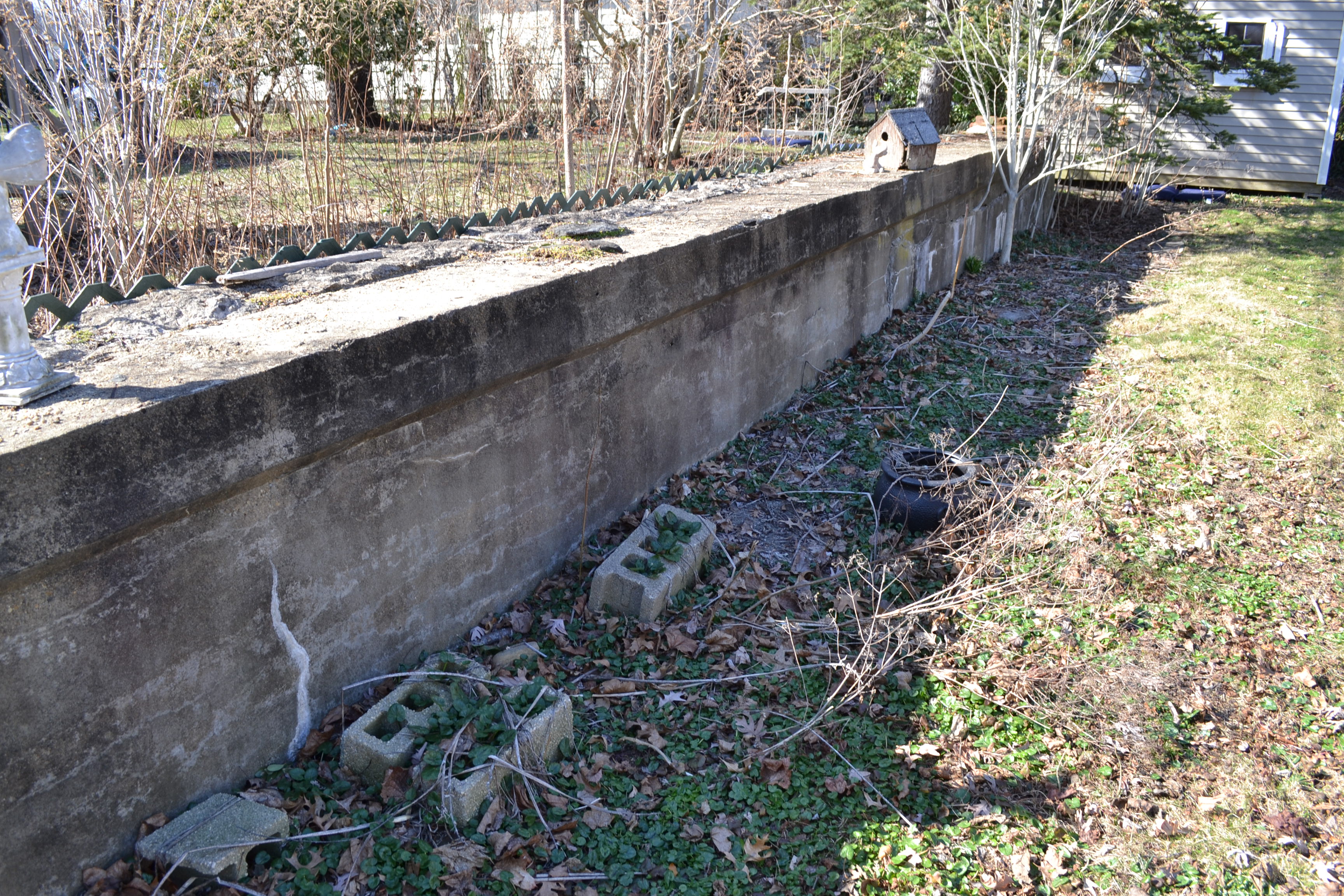
Dave Russo: The "Mayan Ruins" Motor Parkway Bridge in Garden City. I was unaware that BOTH sides of the bridge remain in tact. I thought only one of them existed, next to the swing set.
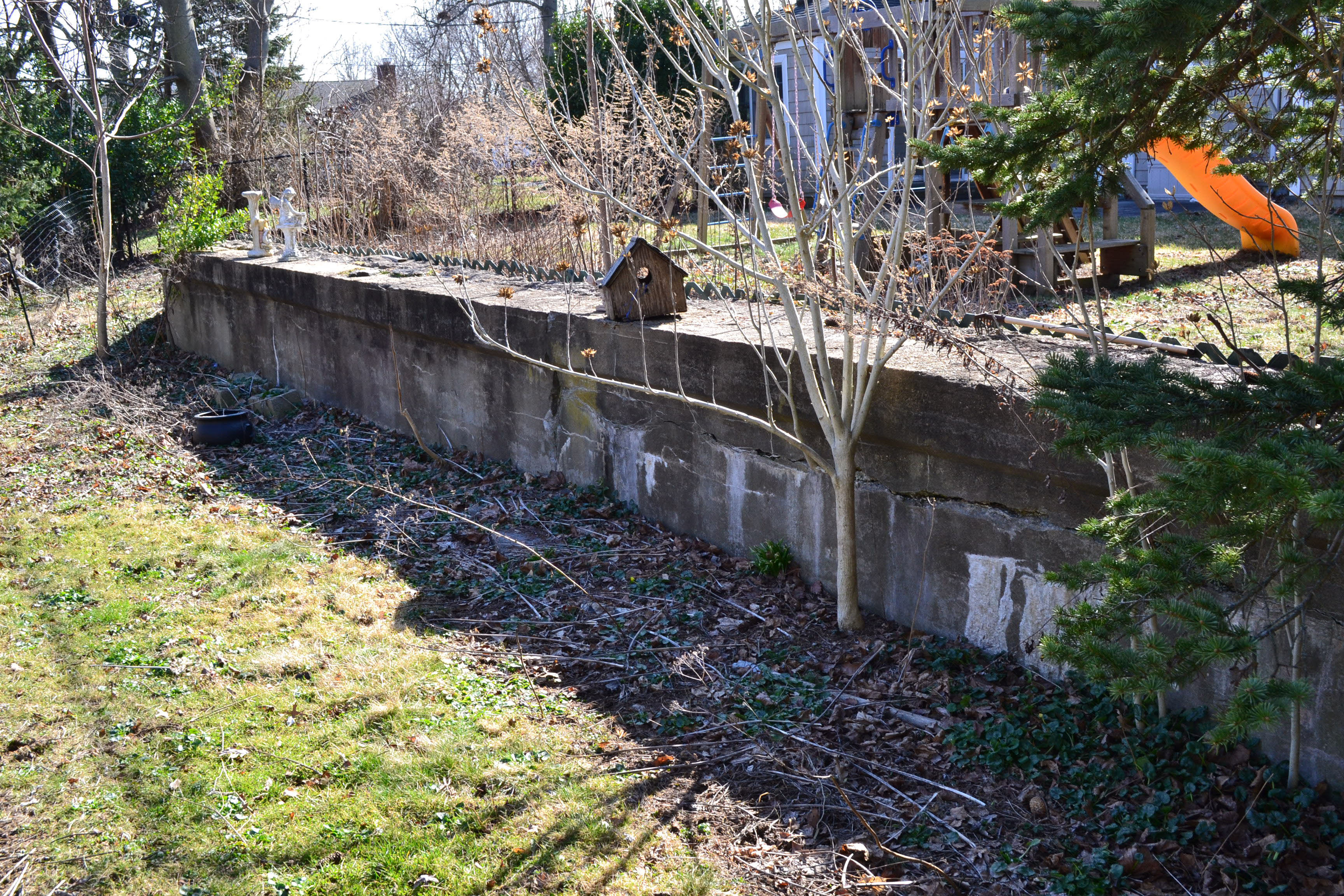
I've passed by that house on Transverse Road many times and only saw the one side - and that's all I really ever saw online and never thought to look the other way (which is more hidden for sure).
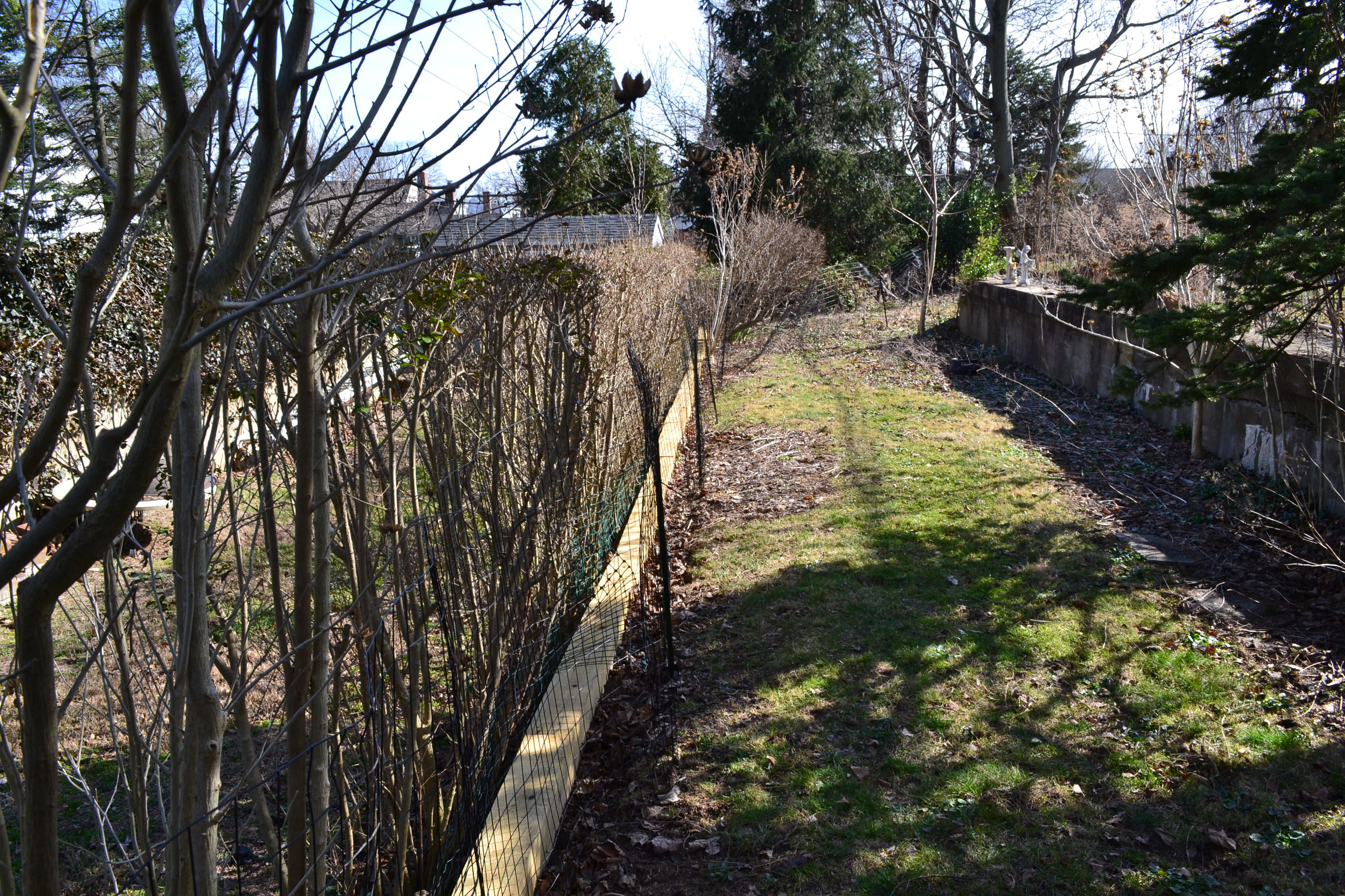
So our intent was to knock on the door of the house and ask if we could see the bridge remnants. Well there is a sign on the door that says the house is abandoned and it's empty. So naturally we helped ourselves to the backyard and took several pics/videos of both sides of the bridge - the eastern side is more or less covered in vines/greenery.
It's not great to see but I think it's very cool that both sides of this bridge still remain - how did the homeowners for over 100 years allow these to remain? It's great that it did.
April 19, 1928 Accident (Courtesy of the Suffolk County Vanderbilt Museum)
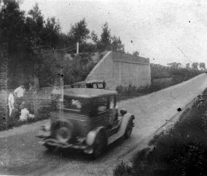
My favorite co-author Al Velocci found this accident report and photos in the archives of the Suffolk County Vanderbilt Museum. Looking north, the photo shows the road clearly below grade with concrete posts above the Motor Parkway. Also note the people on the left at the accident scene and the motorcycle on the right..
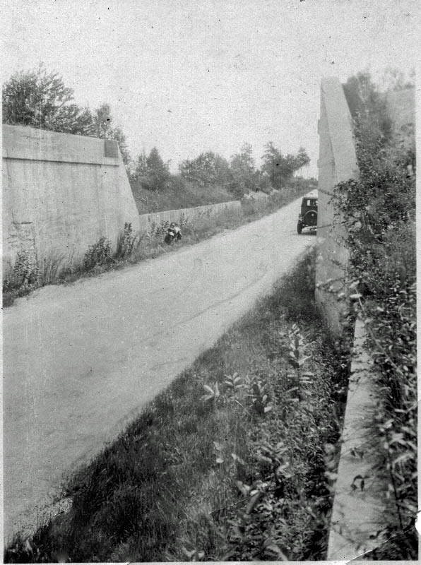
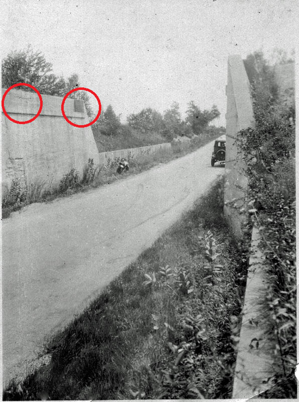
This second image shows the opposite view looking south on the Motor Parkway. Eureka: There are two abutments of an unfinished bridge. Note the motorcycle on the left which was owned by Motor Parkway patrolman Thomas Zinzi.
Submitted by Frank Femenias (see below comments)
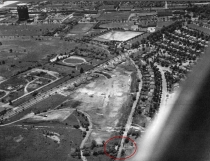
1950 Aerial of the Mayan Ruins


Comments
I have friends that live on Russel Rd. they have the Motor Parkway ROW in the back of their yard.
This was a very interesting find. Amazing that this is still here.
Maybe we can start a little discussion here: looking at the old photos, it is clear that you have the bridge abutments, but then north and south of the abutments you have a small wall. I’m wondering now if the remaining remnants shown in my pictures are of this small wall, and not the bridge abutments???
If it were the abutment it would be the upper portion of the abutment which means, why did they “bury” the lower portion of the abutment? And where did all of that fill come from and why?
And if it was filled, how is it that just south of this location at Arthur Jasper’s house, the original LIMP pavement is still visible - at the same elevation as the regular ground?
I’m thinking my pictures might be of the wall on either side of the former abutments. Let the discussion begin!
Great coverage of this area, Dave and Sam!
The original grade of the LIMP north and south of this unfinished bridge is peculiar. There’s definitely an uprise due north, and also an uprise due south. There had to be quite a low point in the road at this location. I guess this would’ve provided ample clearance for a finished bridge.
Comparing the original and your current photos, it’s clear to me that the flat walls and slopes are quite evident on the east and west sides.
After the LIMP was abandoned, this slope had to be buried/leveled for the future housing. I remember Jaspers LIMP section when inspecting the steel towers, etc. Nice and level, like a backyard patio. When I would walk/patrol thru these backyards, you can tell where the LIMP was buried. Either the ground level would be a bit high or low, right up to Old Country Rd.
Always look forward to your travels and findings, Dave and Sam!
I’m back. Now I see the “lower walls” that are on each side of both abutments, Dave. After watching your video clip, I’m convinced those lower walls are buried. On the older photos of the abutments, there’s a “crease” maybe 1 and 1/2 ft down from the top. And then on each side of the abutments, the concrete angles downwards. In the beginning of your video, I definitely see the “crease” and angled concrete. I don’t know if you measured the height of the exposed abutments, but guessing their 2 and 1/2 to 3 ft high? Knowing how high they are not terribly important.
I wonder if your next adventure is exploring the southside of the past Old Country Rd underpass. Probably need a shovel for that one. We’ll get the Oak Island Team over their!
Dave, glad you found it. Both sides of the unbuilt bridge are shown on my website link below. I’m fortunate to work with the daughter of the homeowner on whose property lies the east abutment and who has invited me to explore a few times. I always tell him that one day he’s going to wake up and find me with a backhoe digging up the parkway between the abutments. Its got to be there.
http://www.freewebs.com/limparkway/gardencityunbuiltbridge.htm
Art
Good job on that find and hope you explore more to find what might be their
Great find again Sam and Dave. Always fun reading about your LIMP adventures.
And good point Dave. I’m guessing today’s protruding walls in GC are most likely just the bridge abutment caps (highest point) as seen in the Suffolk County Vanderbilt Museum photos provided by Al Velocci. Also I agree with Brian McCarthy of the converging slopes being the lowest point under the bridge, as well as the creased caps on top of the abutments. Being just the caps in GC, one would not have to dig deep here before revealing the top of the indented wall below. I don’t see caps on the lower outer walls in Al’s photos, and their heights are much lower than the abutments allowing them to be entirely buried first. I’m estimating there’s 9-10 feet of dirt (at its deepest) before reaching the parkway down below, by subtracting how much wall is exposed today from its actual height in the photo. A lot of dirt was once delivered here!
One other thing; in the old photo there’s a sturdy bridge sign placed on the cap, on the north side of the inner west abutment just before it slopes down 45 degrees. I believe you were facing south while filming the video (guessing it was afternoon by the shadows). At the very beginning of the video (0:00), the inner cap just left of the 45 degree slope shows a smooth surface with no crease compared to the rest of the wall, indicating where the sign was once positioned. It’s been years since I’ve visited here and will have to go back for more fun soon.
That’s my two cents. Anyone, please chime in at will. Corrections gladly accepted here.
P.S.: The car accident in the old photo at Mayan Ruin bridge was the result of its right-rear rim/tire coming off the vehicle causing it to turn over. Two occupants of the vehicle, a man and woman, were rushed to Flushing Hospital by a passerby. The extent of injuries were unknown as written on a report by Motor Parkway Police Officer Thomas Zinzi on Aug 19, 1928. Zinzi’s motorcycle is seen in both photos.
http://www.vanderbiltcupraces.com/blog/article/vanderbiltcupraces.com_exclusive_thomas_j._zinzi_the_first_motor_parkway_po
Brian: Love you man but I completely disagree!!
Look at the old pictures. From the top of the abutment to the “crease” there has to be at least 3 feet before the crease. Now look at my pictures, there is only like 8-10” there. It’s not the same! And there are no other “creases” in the abutments pictures so it’s not like we can be confusing it with any other “creases”. I honestly don’t think these are the abutments.
Next—-if this were the abutment, you see in the old pictures those things are at least 12-14 feet tall. The remaining wall is only about 2 feet tall. It can’t be that 10-12 feet of that abutment are underground! No way!
And about a block away at the Jasper house the original road pavement is right there in his backyard at present elevation. From this “abutment” location to the Jasper backyard - if in fact the abutments were buried, there would ABSOLUTELY be a noticeable elevation drop from the abutments there to the original pavement in his backyard. I’m totally convinced now that these are NOT the abutments!!
A date stamp would settle everything, but looking at the old pics I don’t even see that there was a date stamp on the abutments.
Art—-great pics on your site. I recall you telling me you knew those people but I assumed you were talking about the ones who lived in the house that I went to. You know the other side with the vines on their wall.
And I will join you with the shovel when you want to go and dig! I also think the pavement is there, but it wouldn’t take long to find it. I think we would only have to go down 6-12” before we found it because I don’t believe those are the abutments. Cant be!!!
Amazing!! Thank you for sharing!! Can we do group trips?
Dave, hard to tell with these fuzzy photos but quite possibly could have been two creases (photo sent to Howard). In the old photo, the inner west abutment shows the first crease about ~10 inches from the top, then second crease (the bottom of the cap [crown]) about ~3 feet. The east abutment photo showed only smooth wall (fuzzy photo). In your video of the west abutment, the 10 inch crease can be seen early but then is interrupted with a lower crack produced over time, then returns 10 inches towards the south end of the west abutment. The location of the sturdy sign at the north end (very beginning of same video) is smooth without creases. This can be the most likely location of the sign. The video you and Sammy provided has opened more channels for solving the mystery behind the Mayan Ruins. Always love to see your adventures.
My guess the roadway is still buried under there, after some ~90 years, and it’ll take some ~10 feet of shoveling to reach the LIMP road surface. It’s that deep. That’s my best estimate.
Thanks Dave. Yes, I know the “vine” people. I’ll let you and the others haggle over if they are abutments or a wall or whatever, but one thing is for sure, they are something! Hope you and Sam are doing fine!
I’m open to the wall theory, Dave. Those walls look fairly long ( total of 4 walls). Maybe what’s exposed is the south walls? If this is the case, then the abutments would’ve been demolished and then a whole lot of ground leveling was done. Can’t tell from the older photos if the walls angle downwards at their ends.
Frank, your attention to detail is superb. I see what you’re saying about that bridge sign on the cap. That would be cool if this were the spot of that sign (would be really cool if that sign were still there!) but I don’t think so. Again on the old pics that space from the top of the abutment to the crease is MUCH larger then what is on that wall in the video. I can’t get beyond that. I wish we had more old pics of that space showing the walls in more detail. I’m sure there was a 45 degree slope the end of the wall.
Darn it! I wanted to watch your video clip again, Dave. It became some kind of word jumble somehow.
Testing this would be easy, a single shovel and another visit to the Ruins. If today’s walls are already nearly 3 feet in height, then just a few more inches down should reveal the second crease from the top (the larger one). Is the west wall on private property today? As per Hector, a group trip soon is in order!
Why can’t I stop obsessing over this?
Were you facing south when making the video clip, Dave? Reason I ask because if you were facing south, then the sign that’s placarded would be on the east wall ( going by the older photo facing south that highlights the sign ). You stated that the east side was more hidden with greenery, etc. Maybe the sign is still there, just blocked by the growth?
Frank, I don’t see two creases in the old photo. I only see the one big one - I would think if there was a first crease it would be more visible in the older pic as it is quite prevalent in my 2016 pics.
And how do you answer my other question: if in fact 10 feet of dirt was piled in here and the LIMP sits 10 feet below the ground, how on earth is the pavement visible at current grade in Jasper’s backyard about a block away with zero noticeable signs of grade changes?
And why would there be no date stamp on these abutments? I can’t see them on the old pics.
The west wall (abutment) is in a backyard that was abandoned as per a sign on the door when we did this last March. I’m sure by now someone has bought this house and moved in—- it is Garden City after all.
I concur with Hector this needs to be explored—- and Art you need to ask your friends on the other side of the road if we can come over with shovels and explore this thing further! We will promise to fill in any holes that we make!
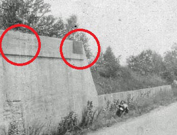
Finally, am I nuts or on the old pic that you marked up Frank—- in the lower left hand portion of the abutment - did someone carve in a whale that is blowing water out of it’s spout??? It really looks like one!
Jasper’s place may be at the top of the hill or just beyond where it’s level, even though he’s just a block away. Based on the photo, I’m estimating ~150 feet from the abutment to the top, another 150 feet going the other way. Other estimations gladly accepted, please feel free anyone. So if Jasper’s house is outside this range, the parkway was always leveled in his backyard when his house was built. I’m trying to locate his house so I can measure from the walls in Google Maps. I see two candidates that MAY have a roadway in their backyards; one house is to the north where the LIMP ran as a strait-a-way, and the other to the south where it curved towards the Clinton Rd bridge. Do you recall his house number on Russell Rd? Please send to the link below. The walls can be seen in Google Maps using Historic Imagery on 4/2004, and 5/2007.
The sign that was once fixed to the bridge may have had displayed the year and other information. With Howard’s zoom feature, I can almost swear the lettering was raised or embossed.
The left red mark on the photo may be the same large crack today that is horizontally centered on the abutment, and just below the 10 inch crease in the video.
The ROW posts are located high in the photo. Motor Pkwy Inc. purchased this land level, then carved out a trench to allow passing under a bridge. Though culverts appear in other locations, I see no drainage system here. Water most likely accumulated here causing a hazard. The carving on the embankment may have been the result of striking the wall after hydroplaning. After the parkway closed, Garden City joined the fun and refilled the trench eliminating the flood problem.
This is all speculation and fun at the same time. Let’s get there soon to settle the “Mayan Ruin Mystery.” I’ll dig a few inches but WILL NOT dig 10 feet down!! :D
.(JavaScript must be enabled to view this email address)
Brian, yes I was walking/facing south on the video. And you’re right. According to the old pics it says when facing south the sign was on the left (east). I highly doubt that sign is still there (I don’t even think it’s the abutment) but I say we pressure Art to call his “vine” friends over there and persuade them to let us explore!
Thanks, Dave. All those times I’ve been in those backyards during work, but never thought of having a camera.My photographic memory only takes me so far, lol. I agree, let’s form our own quicker version of a Oak Island Team! Comment #23, over and out.
1913!! The upper third on the bridge’s sign reads 1913 in larger numerals, only through Howard’s zoomed photo. I was able to observe this using the phone. The larger PC screen was actually more difficult to read.
Brian, you may be correct. P.O. Zinzi’s accident report indicates the car was travelling east (actually south) when it lost its tire causing it to overturn. This stretch of roadway runs north-south. It’s assumed the car is resting on the closest shoulder (west shoulder) if he was heading east. If this is true, that would make the abutment sign on the east abutment.
Brian, you have a good lead there! Check the east abutment at its south end under the brush for the sign. If it’s not there, it could be in Garden City Public Works buried deep.
Okay - I’ll take the challenge. Will contact the homeowner once the snow melts and will see if he’ll permit some of us to take a road trip to explore further (that is, to “dig” up some more clues to put an end to all this haggling! lol).
Oh my gosh, here I am again. Frank, besides being a expert mapper, you being able to make out the year on the sign amazes me.
Art, if you can work it out, I definitely want to be there when the time is right.
We may set a new record on the amount of comments for a blog!
Dave, you asked for a discussion about this location. And a discussion you received.
Dave - Strange carving on the wall indeed. The vertical lines don’t correspond to side swiping with a vehicle. It appears the image of an Indian boy with feather on his head facing north, arms extended forward and carrying a large knapsack. Is this where the Mayan name was derived from? A strange historic Indian burial ground site, casting spells to those who interfere. I’m ready to start digging :D
I’m not sure what kind of pixels you have on your phone Frank! I can’t make out any date at all! But clearly you are gifted with this stuff!
I clearly see a whale blowing water out of his blow hole on the old pic of the abutment. No doubt. Maybe they dug this so deep they struck water!
Art, this is all in your hands now. No pressure. Hurry up 😊
Unlike the Caroline St. posts location, we might actually be able to figure something out at this site!
Dave, thanks for the info. Jasper’s Motor Parkway house (located south of the Mayan Ruins walls) is situated ~520 feet to the south end of the walls. He is out of range of the slopes pertaining to the Mayan Ruins bridge. In fact, his house sits at the very beginning of the curve towards the Clinton Rd bridge. A very slight upgrade towards the south end of his yard is expected. Overall, he is on level ground.
Dave, I own an older version of Android, nothing special. But with any phone, if you go to the zoomed photo with the red circles that Howard posted (while zoomed OUT to the max, this is important), THEN click the zoomed photo for the zoom feature, and THEN zoom in even further with your fingers to the max. This will produce the clearest possible image of the sign and the year in its upper third of the sign. Take your time viewing. The ‘9’ and ‘3’ are clearly there, and the only digits that can possibly fit between them are ones ‘1’. Check it out!
Great job Sam and Dave.
I grew up at 32 Pell Terrace in G.C. The former LIMP was in our neighborhoods’ back yards.
We played army and ‘cowboys and Indians’ on these ‘walls’ which were next door behind 30 Pell Terrace and a house on Russell Road.
At that time in the mid ‘50’s, the top of the west wall was about 9 foot high and the east wall about 6 foot to the top. As I recall, the lower walkable portions of the walls were about 30 inches below the tops and about 12-16
inches wide.
We also road our bikes north to Old Country Road and further north to near E.J. Korvettes on long stretches of the former LIMP The bridge over the LIRR line running through Mineola was an interesting place to watch the trains from especially the last of the steam engines.
We also used to ride our bikes and sleds down the hills on the east and west sides of Clinton Road where a former bridge carrying the LIMP had been. Riding our bikes on the abandoned roadway east of Clinton Road was a great shortcut to our Little League ball fields behind Stewart Elementary School.
It was a great place to grow up as a kid in the 1950’s.
Hi Robert - Fantastic story about growing up near the Mayan Ruin walls in Garden City. Just today a group of LIMPPS members met this morning by the walls. With permission, we witnessed the entire Russell Rd wall has been reduced to approx 3 ft. In height. The Pell Terr wall now stands half at 8 ft., the other half at 3 ft. It must have been some fun back then with the huge structures standing tall out of the ground!
Hi again Robert - When playing by the walls in the fiftys, while they were still 8 ft. high, do you recall a dark sign/plaque affixed on the top edge of one of the walls? If so, do you remember what the plaque read?, year? The sign once fixed to the wall was missing today.
Robert——great stories! What is / was EJ Korvettes? Riding sleds down onto Clinton Road doesn’t sound very safe! But then again….young boys aren’t the smartest things out there!
You MUST have pictures of the abutments in the backyard! If you do have them please let us know! Or any other LIMP pictures would be cool too but the abutments especially would be great.
Hi Frank,
Thanks for your reply. The tops (about 24-30 inches) of these walls were removed. It is very evident by the current state of the concrete on the entire length of the tops of the walls. The Angelillo’s who lived at 30 Pell Terrace might have had the demolition done or the next owner. It did improve the view from the house to the east when looking west. The Russell Road property owners may have done the same thing for the same reason. I would guess what ever they knocked off was just dumped into the back sides of the wall, ending up as fill. Digging on the interior sides of the walls would probably verify this. I doubt they had it carted away. I do believe the original LIMP road surface is 8-12 ft. below the current dirt surface.
The bottom picture which shows the rear of the extensively remodeled home at 30 Pell from behind the east wall of the LIMP planned but never constructed bridge, shows the back NW corner of our former home at 32 Pell. My parents had the home built in 1953 and three windows shown are located in the dining room. There was a potato farm field all the way to Old Country Road to the north of this initial development. There were 12-15 nearly identical split-level homes built on Pell Terrace, Iris Lane and Avalon Rd. Most if not all of the homes in this development have been remodeled for obvious reasons. During the end of the last century, homes which sold new for $15K-$17K in the mid ‘50s started topping $1M, especially after extensive renovations and upgrades.
Never saw any evidence of signage on or around these walls but there could be some such things buried around the ‘walls’, but probably pretty far down.
Let me know what you find out.
Robert - Amazing information about Garden City, thank you! Quite possible the sign could be buried deep (removed early for aesthetics purposes). Thank you for responding and for the abundance of information about the area. The puzzle has become clearer!
Frank,
I believe I might have some deeply buried slides/photos and I will get the images to you when I can…Please don’t hold your breath.
Thanks for your comments on my posts.
Bob
Dave,
Man am I dating myself…EJ Korvette’s was our 1950’s version of
Walmart. The name supposedly came from the fact that [E] ight [J] ewish [Kor] ean War [Vet] eran[s] founded the retailer. They had stores across the NYC area.
Bob
__________________________________________________________
Howard Kroplick
Bob, this is an article from Haaretz.com on E.J. Korvette’s founder Eugene Ferkauf and the Korvette name:
Americans of a certain generation know the urban legend that “E.J. Korvette” is short for “Eight Jewish Korean War Veterans.” In fact, Ferkauf, who didn’t serve in the Korean War, took the E. from Eugene and the J. from his friend and partner Joe Zwillenberg, while Korvette was an alternate spelling for Corvette — the warship and sub-destroyer, not the car. Ferkauf thought it “had a euphonious ring,” he wrote in a memoir.
http://www.haaretz.com/jewish/this-day-in-jewish-history/.premium-1.659698?=&ts=_1492699266432
Mr. Stambaugh….Frank and many of us are quite glad you’ve been sharing your memories here. Frank and I became sort of a dynamic duo with the LIMP. Correct me if I’m wrong, but I think Korvettes was at the S/W corner of Glen Cove Rd/Voice Rd. Pretty much all the buildings are still there, but became new stores etc. I know that Voice Rd deadends to the former LIMP ROW. The steel tower lines run parallel with the LIMP thru out. A group of us were invited to view the abutments in the R/O #30 Pell Terrace. We’ll have to ask the current owner if we could poke around his garage LOL.
Roger—-very cool store back story for where that name came from. Now get searching for those old pictures / slides so maybe we can put this abutment mystery behind us!
Where is this Ralphie guy? Is he still around? Kids?
Thank you Robert. You are one of very few that may hold links to Long Island’s past. Past photography was expensive and likely not part of many leisure outings. It would be a treat for many, including myself, to learn Long Island’s history from a new perspective.
Frank,
I believe I might have some deeply buried slides/photos and I will get the images to you when I can…Please don’t hold your breath.
I will tell you this too, IF there was ever a visible sign on or near these walls, our neighbor Ralphie at 30 Pell would have found it and had it hanging in his garage but, I never saw one. Their house was built a few years before ours. Ralphie (GCHS Class of ‘59, Marine Vet) was a god to us neighbor kids, actually looked like ‘Adonis’.
Thanks for your comments on my posts.
Bob
Hi Guys,
Unfortuanately Ralphie passed away late in the last century from ALS. He was an only child, had been married, but had no children which I can recall. He owned a dive shop somewhere out in The Moriches. He was a loner and would dive solo with tanks all along the south shore of Long Island. He probably had quite a collection of found items.
Your recollection of the EJ Korvette’s location is correct. Near where Big Lots is today.
Best Regards,
Bob Stambaugh
Robert…. So sorry for the outcome of your past neighbor, Ralphie. I used to work along with someone quite a few years ago. He was a hard worker, and a gentleman. He also eventually succumbed to ALS. He reported to work until it was physically impossible, and you never heard a complaint out of him. He’ll never be forgotten by those who knew him.
Hi Bob - Sorry to hear about Ralphie. ALS is rare but still a nasty bug.
Another one I seem to have missed or to which I forgot to respond. As I just added to the later post on 19 Apr 2017, you can see 31 Jan 2008 pix at <http://sbiii.com/limpbrdg.html#gardcity>. Sam, III
Rather late in the game but I just noticed the E. J. Korvette location noted above and beg to differ. As I recall, and I’m pretty sure of my ground here, it was on the south side of Westbury Avenue, roughly opposite Park Avenue, where the Marriott and Hilton are today but more likely where that big, empty parking lot is now, just east of the LIMP RoW and west of the SpringHill Suites by Marriott Carle Place. Sam, III