Historic Views of Roosevelt Field, the Motor Parkway and Lindbergh’s Takeoff
As shown in this 1938 aerial, the Long Island Motor Parkway was located to the west and south of the historic Roosevelt Field airfield. Here are other historic photos of Roosevelt Field and the Motor Parkway

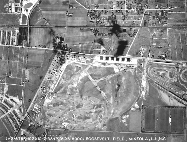
This is a 1926 aerial of Roosevelt Field looking north. The Long Island Motor Parkway was along the dotted yellow line surrounding the airfield. I believe this is the only aerial showing the temporary road that connected Ellison Road to the Motor Parkway for the 1908,1909 and 1910 Vanderbilt Cup Race courses.

In 1919, Long Island became part of aviation history when an airship crossed the Atlantic Ocean for the very first time and ended its voyage at Roosevelt Field. In this photo, the British Army's 643-foot dirigible R-34 can be seen after landing. The men on the left were standing on the Motor Parkway Bridge located on the spot where the current Zeckendorf Boulevard Bridge over Meadowbrook Parkway is today.

One of the busiest days on the Motor Parkway was June 16, 1927, when Charles Lindbergh returned to Roosevelt Field to celebrate his successful solo flight to Paris. Lindbergh had taken off from the Roosevelt Field eastern runway 27 days earlier. The cars on the bottom of the photo were lined up on the southern border of the Motor Parkway.

Here is a close-up of the Motor Parkway Bridge leading to Roosevelt Field on the day of Lindbergh's 1927 reception. According to Al Velocci's book The Toll Lodges of the Long Island Motor Parkway , and Their Gatekeeper's Lives, Charles Lindbergh was a frequent user of the Motor Parkway entering and exiting at the Garden City Lodge. The lodgekeeper's daughter Peggy Williams "vividly recalls meeting him, and her father and Lindbergh having nice chats".

Robert Richer has forwarded this website featuring four amazing videos of Lindbergh's flight from Roosevelt Field to Paris. Part 3 shows a spectacular film of the takeoff. Watch Lindbergh barely make it over the telephone wires on Merrick Avenue. Robert notes:
Win Perkins, a real estate appraiser who specializes in airport properties, has posted on his Web site a video he created of Charles Lindbergh's famous and risky takeoff in the Spirit of St. Louis. According to Perkins, this is unlike any other presentation of the takeoff footage. Perkins said he "painstakingly assembled news footage from five cameras that filmed Lindbergh's takeoff from Roosevelt Field, Long Island" and "mixed it with enhanced audio from the same newsreel sources."

This 1935 diagram of Roosevelt Field shows the location of Lindbergh's takeoff relative to the Long Island Motor Parkway.


Comments
Where is the web site for Lindbergh’s flight?
Hi Richard:
Here is the link again: http://www.airportappraisals.com/contact/
Lindbergh’s flight is discussed in all 4 parts. Part 3 shows the takeoff.
Howard
I notice the runway depicted for Lindbergh’s takeoff in the 1935 diagram is 3800 feet long and different from the longer runway (4700’) with the Byrd ramp. In some other books/publications, they refer to Lindbergh using a 5000 foot runway, the same one Byrd had built for the America. Do you know why there is a discrepancy?
Due to the comparing of metric vs hydroforce levels. Started in 1922 at the Hanz field down the road.