Tag: Mapping The Motor Parkway
-
Feb 04 2020
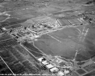
Kleiner’s Kolumn: Part 2- Mapping the Motor Parkway, Mitchel Field & Mitchel Gardens
This post continues with my examination of Mitchel Field documents provided by the Nassau County Dept. of Public Works and pertains to post-WWII development of the area.
-
Jan 21 2020
Kleiner’s Kolumn: The 1941 Suffolk County Map of The Motor Parkway
As a follow-up to my Jan. 11 post pertaining to the acquisition of the Motor Parkway by the County of Suffolk, I'm pleased to present the map prepared in 1941 detailing the 77 parcels included in the transaction.
-
Dec 18 2019

Kleiner’s Kolumn: Part I-Mapping the Motor Parkway, Mitchel Field & Mitchel Gardens
Recently received documents from the Nassau County Dept. of Public Works (NCDPW) highlight the Motor Parkway and Mitchel Field in Garden City.
-
Dec 14 2019
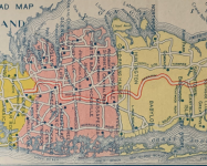
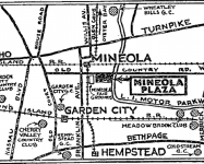
Kleiner’s Kolumn: The Long Island Motor Parkway in Maps (Part III)
Part III of the map series provides a further look at the Motor Parkway as depicted on various types of maps.
-
Dec 05 2019
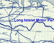
Kleiner’s Kolumn: The Long Island Motor Parkway in Maps (Part II)
Part II of my map series displays maps that were used for what I call specific purposes and generally not for touring.
-
Nov 26 2019
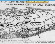
Kleiner’s Kolumn: The Long Island Motor Parkway in Maps (Part I)
As a follow up to the November 20, 2019 post showing the Motor Parkway on a 1927 map, here a number of other maps I've collected and/or saved from various newspapers including the The Brooklyn Daily Eagle, Brooklyn Life and The New York Times.


hi, how do you date the chassis of a car with the fedco plate? my fedco plate read
YYY EEE ZERO THRE ONE WWW, so the…