Tag: Maps
-
Sep 20 2023
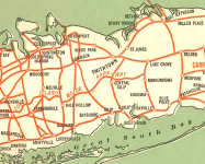
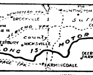
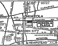
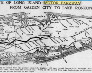
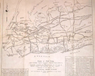
Kleiner’s Korner: Assorted Maps of the Motor Parkway
Following up on my previous post concerning maps showing the Motor Parkway produced by the NY Daily News here are numerous others by various publications.
-
Sep 16 2023
Kleiner’s Korner: “NY Daily News” Maps of the Motor Parkway (1929-1937)
As part of its coverage of the development of the metro-NY area in the early 20th century, the "NY Daily News" often included maps in its stories. Included in these were maps of our favorite roadway, the Long Island Motor Parkway.
-
Oct 06 2021
Greg O’s Garage: A 1906 Nassau County Map
An early, unique map of Nassau County
-
Jun 01 2020
Mystery Foto #22 Solved: South Street On the Motor Parkway Right-Of-Way in East Garden City
My favorite co-author Al Velocci challenged you to solve this weekend's Mystery Foto.
-
Dec 05 2019
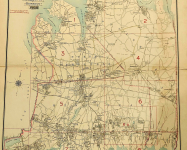
Kleiner’s Kolumn: The Long Island Motor Parkway in Maps (Part II)
Part II of my map series displays maps that were used for what I call specific purposes and generally not for touring.
-
Nov 26 2019
Kleiner’s Kolumn: The Long Island Motor Parkway in Maps (Part I)
As a follow up to the November 20, 2019 post showing the Motor Parkway on a 1927 map, here a number of other maps I've collected and/or saved from various newspapers including the The Brooklyn Daily Eagle, Brooklyn Life and The New York Times.
-
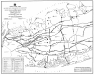
Nov 20 2019
1927 Map Showing the Long Island Motor Parkway and Proposed Highways & Parkways East of Queens
In August 1927, New York Governor Alfred E. Smith requested that his Cabinet's Committee on Public Improvements develop a map of the proposed highways and parkways in Nassau County and Western Suffolk County. The map also featured the Long Island Motor Parkway.
-
Apr 08 2017
Survey/Mapping Expert Examines the Recently Discovered Motor Parkway Treasure
Dan Jedlicka, Vice-President, Director of Survey and Mapping for L.K. McLean Associates, visited the Waterfront at Roslyn Garage today to examine the Motor Parkway surveys and maps recently discovered in Malverne by contractor Roy Knoernschild.
-
Oct 15 2016
1925 Long Island Map of Queens Traffic Arteries & Proposed Highways and Parkways in Nassau & Suffolk
In 1925, the New York State Department of Public Works and the Long Island State Parkway Commission prepared this map at the request of Governor Alfred E. Smith.
-
Jun 11 2016
The 1914 Goodrich Long Island Route Book & the Goodrich Road Markers Updated: 6/13/16
I recently came across a mint condition 1914 Goodrich Long Island Route Book. Research into this 5" x 9" brochure uncovered information on the first road signs and road maps used in the United States.


Rollin’s granddaughter Betty King had this medal. She said she gave it to the National Inventors Hall of Fame Museum…